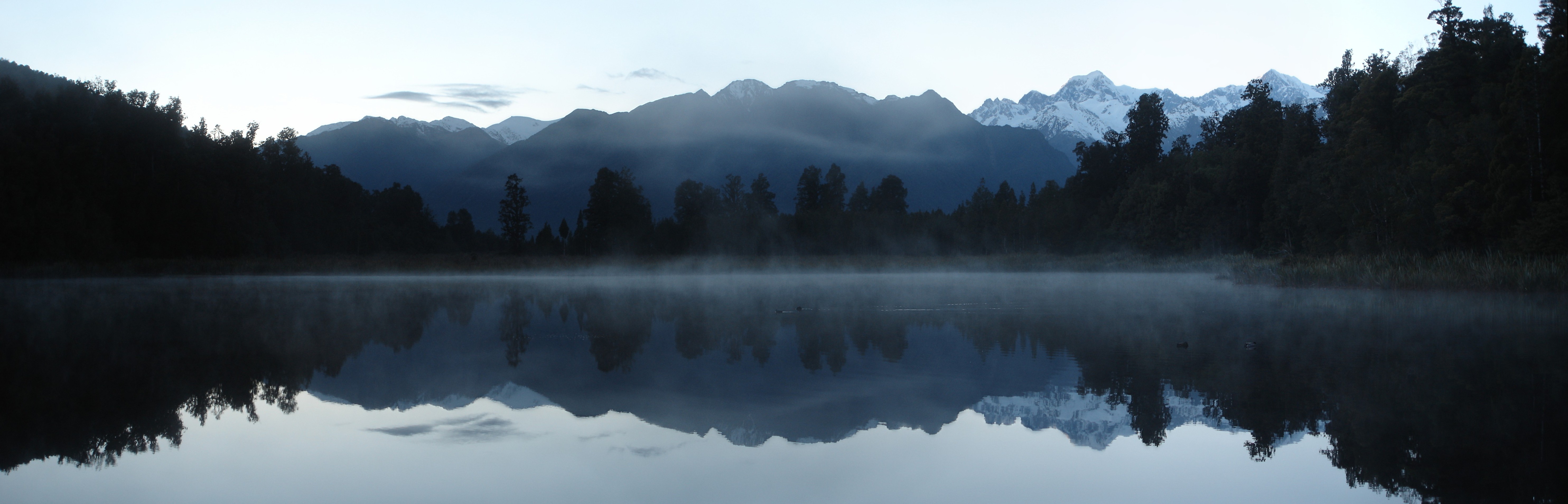
Lake Matheson
In the 1950s, a bus would collect guests from the Fox Glacier Hotel before dawn and drive them to a trailhead in the bush. A 15-minute walk led to a rowboat, which ferried them out to a tiny island called Reflection Island. There, in the dark, they would wait -- for the ripples to subside, for the light to arrive, for the moment when the surface of Lake Matheson became a perfect mirror of Aoraki / Mount Cook and Mount Tasman. That view has since appeared on at least five New Zealand postage stamp issues. The rowboat is long gone, but the reflection endures.
Born from Buried Ice
Lake Matheson exists because of a chunk of ice that refused to melt quickly. Fourteen thousand years ago, as Fox Glacier retreated at the end of the last glacial period, it left behind a massive slab of ice insulated beneath a thick layer of moraine gravel. The glacier pulled back, but this buried remnant lingered, slowly collapsing over centuries to form the depression that became the lake. Two moraine terraces hemmed the water in. No major river feeds it and none drains it -- the lake fills from small streams and seepage, dammed by moraines, outwash gravels, and river deposits. Today it sits about 12 kilometers from the current terminus of Fox Glacier, a quiet relic of an ice age that shaped every contour of this valley.
Dark Water, Slow Death
The stillness that makes Lake Matheson such a flawless mirror is also a sign of what scientists call a dystrophic lake -- one that is slowly accumulating organic matter and will, given enough time, fill in completely and become a peat bog. The water is brown, acidic (with a pH recorded as low as 5.5), low in nutrients, and sometimes nearly devoid of oxygen. Streams that feed the lake pass through dense native bush, and after heavy rains they carry in foam from decomposing vegetation. At 30 hectares with a shoreline of about 1.5 kilometers and an average depth of 12 meters, the lake is modest in scale. Its fame comes entirely from what it reflects, not what it contains. The dark, tannin-rich water acts like a natural darkroom, absorbing light rather than scattering it, which is precisely why the reflections are so sharp.
A Forest of Ancient Names
The walking track that circles Lake Matheson passes through native podocarp forest that reads like a botanical inventory of pre-European New Zealand. Hall's totara and southern rata form the canopy near the water's edge, joined by kamahi and rimu. Higher up, rimu becomes more dominant and Quintinia serrata appears. Miro, broadleaf, kahikatea, mountain horopito, and pate fill the understory. This forest is not just scenery -- it is an active conservation site. In 2018, a local ecotourism operation partnered with the Department of Conservation to launch Project Early Bird, setting 80 traps around the lake to catch introduced stoats and rats that threaten native bird populations. The effort has contributed to the return of bird calls that had been growing quieter for decades.
Stamped into the National Identity
Few lakes have been so thoroughly claimed by a country's self-image. The first stamp bearing Lake Matheson's reflection appeared in 1946, a half-penny engraving titled "Peace and Tranquility" commemorating the end of World War Two. The view returned on a 45-cent stamp in 1983's "Beautiful New Zealand" series, on self-adhesive definitives in 1996, on a miniature sheet for the 2001 Philanippon exhibition in Japan, and on a $3.50 scenic definitive in 2012. The lake was named in the 1870s after Murdoch Matheson, a cattle farmer on the Cook River flats -- a prosaic origin for a place that would become one of New Zealand's most iconic images. Managed as part of Westland Tai Poutini National Park, the lake's trails were upgraded with $3.9 million in government investment, including a cycling and walking path connecting it to Fox Glacier township.
From the Air
Located at 43.44S, 169.96E approximately 5 km southwest of Fox Glacier village. The lake is a small, dark oval visible amid dense green native forest, distinct from the lighter-colored rivers and glacial outwash nearby. Best viewed from 3,000-5,000 ft AGL. Aoraki/Mount Cook and Mount Tasman rise to the east-northeast, and on calm days the reflection that makes this lake famous may be visible from altitude. Nearest airport: Hokitika (NZHK). Fox Glacier helipad is nearby. Part of Westland Tai Poutini National Park.