Lake Nakuru National Park
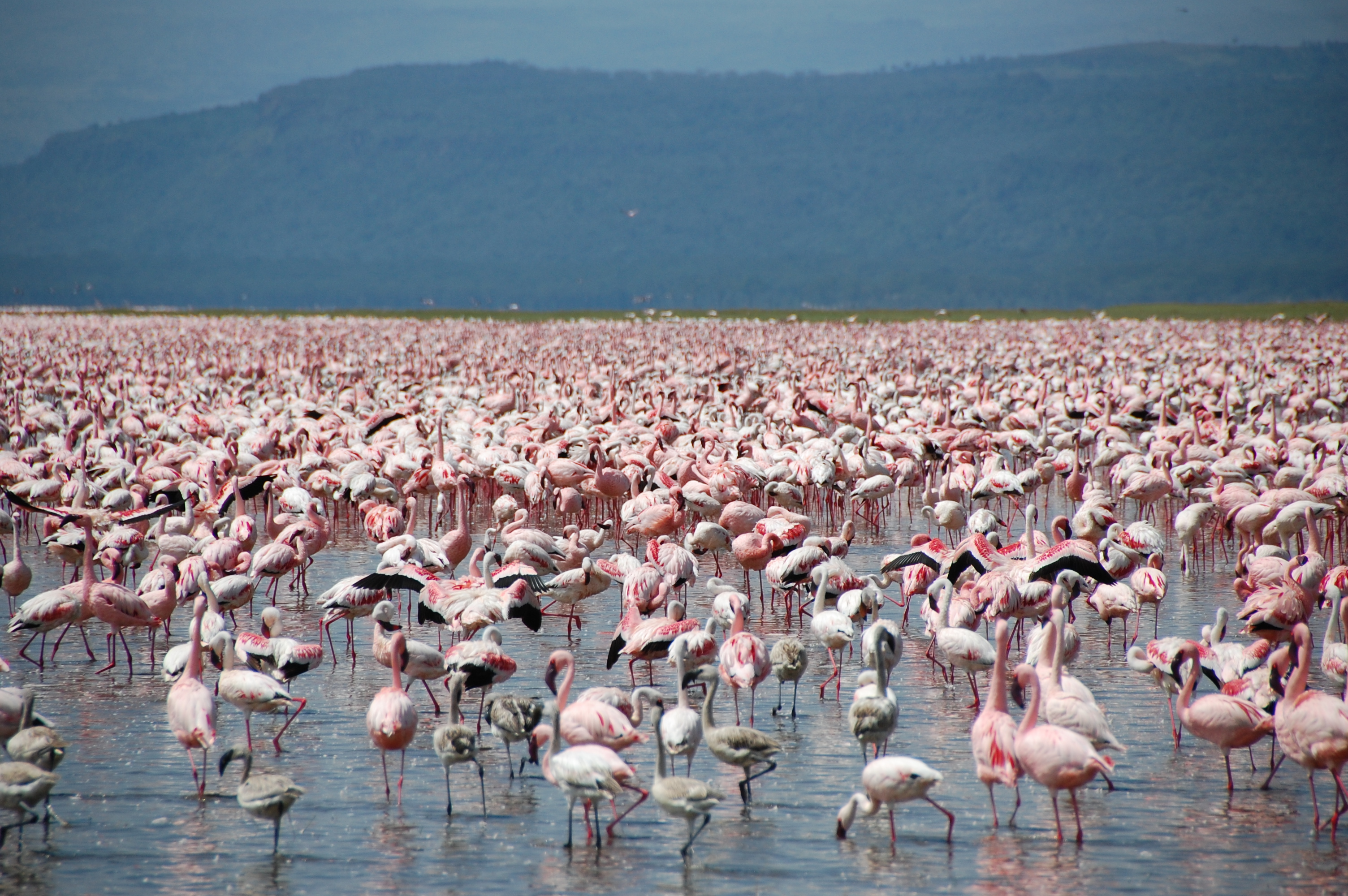
Two million flamingos do not arrive quietly. When the lesser and greater flamingos gather on Lake Nakuru, they form a pink mass so dense it reshapes the shoreline from the air, turning the shallow alkaline water into something that looks less like a lake and more like a living pigment spill across the Rift Valley floor. The birds stay for much of the year, migrating only between the chain of soda lakes that run along the Great Rift from Bogoria to Elementaita. Lake Nakuru National Park exists because of them, though what the park has become since its founding protects far more than birds.
From Bird Sanctuary to Fortress
The park's story begins in the 1950s as a bird viewing and sport shooting area for migratory species. In 1957 it was declared a conservation area, and by 1961 the southern two-thirds had been designated a bird sanctuary. The full lake and a narrow strip of surrounding land gained protection in 1964, and in 1968 the area was gazetted as a national park. Then the mission expanded. In 1977, a group of Rothschild's giraffes, one of the most endangered giraffe subspecies, were translocated from western Kenya to the safety of the park. By 1984, Nakuru had become Kenya's first government-managed rhino sanctuary, and two years later an electric fence encircled the entire 188 square kilometers. That fence changed everything. It meant elephants could not enter, but it also meant that the rhinos and giraffes inside could not leave. The park became a fortress, and the animals within it became residents rather than migrants.
The Alkaline World
Lake Nakuru is a soda lake, highly saline and ringed by alkaline-tolerant grasses that give the shoreline a pale, almost bleached quality before the green of the surrounding woodland takes over. Depending on the season, the lake covers up to 40 square kilometers, expanding and contracting with the rains. The park itself stretches to 188 square kilometers, encompassing not just the lake but rolling hills, dense forest, and the rare tarconanthus bushlands and euphorbia forests that grow nowhere else in quite this combination. From Baboon Cliff, one of the park's established viewpoints, the full sweep is visible: the pale lake, the dark woodlands, and often the slow movement of buffalo herds crossing the grasslands below. Lion Hill and the aptly named Out of Africa viewpoint offer similar panoramas. At the southern edge of the park, Makalia Falls provides one of the few places visitors can leave their vehicles and walk a short trail through the forest.
A Census of the Visible
Because the park is fenced, wildlife viewing here carries an unusual certainty. White rhinos, African buffalo, Rothschild's giraffes, zebras, impalas, olive baboons, vervet monkeys, and waterbucks are essentially guaranteed sightings. Yellow-billed pelicans glide across the lake surface. Marabou storks stand motionless at the water's edge. Fish eagles call from the treetops with their distinctive cry. More than 400 bird species have been recorded, including five globally threatened species, earning the park designation as both a Ramsar wetland site and an Important Bird Area. The elusive animals are here too: lions, leopards, black rhinos, wild dogs, colobus monkeys, and cheetahs all inhabit the park, though spotting them requires patience and luck. In 2011, UNESCO designated Lake Nakuru alongside Lakes Elementaita and Bogoria as part of the Kenya Lakes System World Heritage Site, recognizing the chain of Rift Valley soda lakes as one of the world's most important natural habitats.
The Rift Valley Corridor
Lake Nakuru sits roughly 140 kilometers northwest of Nairobi, accessible via a highway that climbs through the Rift Valley with views of the volcanoes Suswa and Mount Longonot. A scenic overlook at 2,200 meters above sea level offers a panorama of the valley's immense scale before the road descends to the town of Nakuru. The park has three gates, with the Main Gate and Lanet Gate connecting to the highway and the quieter Nderit Gate to the south. For those arriving by air, the Naishi airstrip inside the park is a 25-minute flight from Jomo Kenyatta International Airport. The climate here is more temperate than Kenya's famous lowland parks. Classified as dry sub-humid to semi-arid, Nakuru lacks the searing heat of Amboseli or Tsavo. Afternoon rain showers are common, and the wet months between April and June bring fewer tourists and greener landscapes. The fence ensures that even during the rains, when animals in other parks scatter across vast migration corridors, the wildlife at Nakuru stays put.
From the Air
Lake Nakuru sits at 0.37S, 36.08E in the Great Rift Valley of central Kenya, about 140 km northwest of Nairobi. From the air, the lake appears as a pale alkaline sheet rimmed by green woodland, often with a visible pink fringe of flamingos along the shore. Best viewed at 3,000-5,000 feet AGL. The Naishi airstrip (HKNK) is located inside the park. Jomo Kenyatta International Airport (HKJK) in Nairobi is the nearest major airport, about a 25-minute flight away. Wilson Airport (HKNW) in Nairobi also handles charter flights to the park.