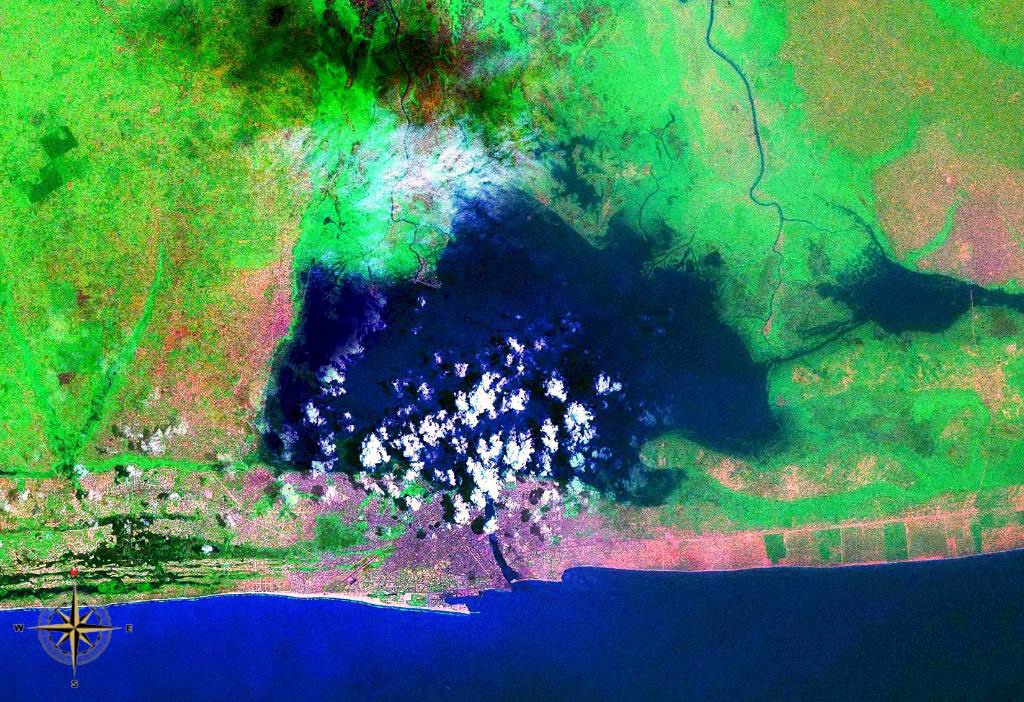
Lake Nokoue
Thirty thousand people live on the water here. Their houses stand on wooden stilts above a lake so shallow -- averaging just 1.5 meters deep -- that the pirogues gliding between them seem to float on mud as much as water. Lake Nokoue sits in southern Benin, twenty kilometers wide and eleven long, covering roughly 4,900 hectares between the city of Cotonou on its southern shore and the stilt town of Ganvie to the north. Fed by the Oueme River and the So River, the lake is not one ecosystem but several, alternating between freshwater and brackish conditions as seasons, tides, and river flows shift the salinity from one section to another.
Built on Water, Born from Resistance
Ganvie, the largest settlement on Lake Nokoue, exists because of the slave trade. The Tofinu people established their community on the water during the era of the Kingdom of Dahomey, exploiting a reported prohibition against Dahomey warriors attacking over water. What began as a survival strategy became a permanent way of life. Today, Ganvie is home to over 30,000 people who fish, trade, and raise children on a lake that serves as road, marketplace, and backyard. Dugout canoes function as the primary mode of transport, carrying everything from people to produce through channels between the stilted structures. The town draws tourists who come for the spectacle of a floating city, though the reality of life on Nokoue is more complicated than any postcard suggests -- sanitation infrastructure is minimal, and the lake absorbs the waste of every community along its shores.
Acadja: Farming the Shallows
Lake Nokoue's fishermen practice acadja, a traditional aquaculture technique unique to this region of West Africa. The method involves driving branches and brush into the shallow lake floor to create submerged structures that attract fish, essentially building artificial habitat in the open water. The technique exploits the lake's extraordinary shallowness -- at an average depth of 1.5 meters, the entire water column is accessible. At least 78 species of fish inhabit the lake, supporting an artisanal fishing economy that feeds both the lakeside communities and the markets of Cotonou. Bird species flock to the abundant fish, and otters hunt along the margins. The lake is a Ramsar wetland site, recognized for its ecological importance, though that designation exists in tension with the pressures that come from being surrounded by a rapidly growing urban population.
A Lake That Cannot Decide What It Is
Nokoue is neither fully freshwater nor fully saltwater. Different sections of the lake alternate between these states depending on the season, rainfall, and the volume of water flowing in from the Oueme and So rivers. The lake floor is a patchwork of sand, muddy-sand, and mud layers, each supporting different communities of organisms. This ecological ambiguity makes Nokoue both resilient and vulnerable -- the shifting conditions support diverse habitats, but any significant change in the balance could collapse entire sections of the ecosystem. Climate change projections suggest the lake could double in size as rising sea levels push saltwater further inland, a scenario that would increase salinization and potentially transform the lake's ecology beyond recognition. The communities that depend on freshwater fishing would face an existential shift.
Poisons in the Shallows
The rivers that feed Lake Nokoue carry more than water and sediment. Pesticides and heavy metals from upstream agriculture and industry accumulate in the lake's shallow waters and settle into its muddy floor. Studies have found that while pesticide concentrations in fish remain below toxic thresholds, heavy metal levels can reach quantities dangerous to both the fish themselves and the humans who eat them. The Lagune de Cotonou, which connects the lake to the city and eventually to the ocean, bears visible evidence of the problem -- garbage piles along its banks, and the water quality tells a story of a natural system absorbing far more than it was designed to handle. For the fishermen of Nokoue, the lake is simultaneously livelihood and liability, a source of food that may itself be slowly becoming unsafe to eat.
Between the City and the Sea
From the air, Lake Nokoue defines Cotonou's geography as clearly as any map. The city presses against the lake's southern edge, constrained on its other side by the Atlantic. This narrow strip of habitable land between saltwater and fresh gives Cotonou its precarious character -- a city that floods regularly from both directions. The lake itself is a mirror of everything happening around it: rapid urbanization, environmental stress, climate vulnerability, and the persistence of traditional ways of life that predate every modern pressure. Fishermen in pirogues still cross paths with missionaries in dugout canoes. The acadja brush piles still attract fish as they have for generations. And on the northern shore, Ganvie still stands on its stilts, a community that chose the water over the land three centuries ago and has not looked back.
From the Air
Located at 6.43N, 2.43E in southern Benin. The lake is 20 km wide and 11 km long, clearly visible from altitude as a large shallow water body immediately north of Cotonou. The stilt village of Ganvie is visible on the northern shore. Cadjehoun Airport (DBBB) in Cotonou is on the lake's southern edge. Best viewed at 5,000-10,000 ft to appreciate the full extent of the lake and the contrast between the urban waterfront and the stilt communities.