Lake Passaic
Somewhere beneath the suburbs of northern New Jersey lies the floor of an ancient lake. Fourteen thousand years ago, glacial Lake Passaic stretched across what is now commuter country -- its waters lapping against ridgelines that today carry hiking trails and power lines. The lake is gone, drained by millennia of erosion and shifting ice, but its ghost haunts every flood season. When the Passaic River backs up behind the Watchung Mountains and the lowlands fill with brown water, the old lake briefly returns, reminding a region of four million people that they live in a bowl carved by ice.
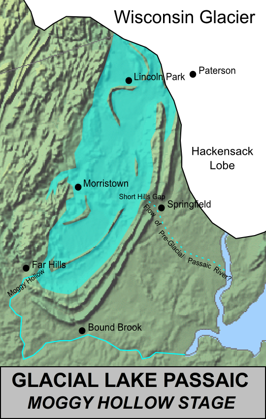
When the Ice Plugged the Gap
The story begins long before the glacier, in the late Triassic and early Jurassic periods, when North America pulled away from Africa and created the Newark Basin -- a rift valley that filled with layers of red sediment and hardened basalt. Over millions of years, erosion carved those basalt edges into the ridges now known as the Watchung Mountains. An ancestral Passaic River flowed through a gap in these ridges, draining the basin to the east. Then, roughly 20,000 years ago, the Wisconsin Glacier advanced and permanently plugged that gap with earth and rock. As the ice sheet melted back, water pooled behind the ridges with no way out. Glacial Lake Passaic was born.
Five Thousand Years of Shifting Shorelines
The lake was not a static body of water. Over approximately five millennia -- from about 19,000 to 14,000 years ago -- it existed in four major stages, each defined by a different shoreline elevation. Ice dams and earthen moraine barriers built up and broke down, sometimes over brief spans of time, sending the water level rising or falling. At its largest extent, during what geologists call the Moggy Hollow Stage, the lake was a formidable inland sea. As it shrank through subsequent stages, the water left behind wave-cut terraces and delta deposits that would puzzle scientists thousands of years later. The final drainage permanently rerouted the Passaic River, forcing it on the winding course it follows today through the northern Watchung Mountains before spilling out into the lower piedmont.
The Detectives Who Found a Missing Lake
Credit for the discovery goes to George Hammell Cook, the State Geologist of New Jersey and Vice President of Rutgers University, who noted the evidence in 1880: flat-topped hills and peculiar deposits in the upper Passaic Valley that looked like the work of standing water. Twelve years later, John C. Smock's field researchers uncovered wave-cut terraces along the basin's edges. But the lake's full dimensions remained unclear until 1893, when geologists Rollin D. Salisbury and Henry B. Kummel mapped the terraces, shoreline platforms, and delta deposits across the entire basin. Their report, Lake Passaic -- An Extinct Glacial Lake, finally put boundaries on a body of water that had vanished millennia before anyone thought to look for it.
The Great Swamp and Its Citizen Army
Today, the lake's former basin is called Passaic Meadows -- a patchwork of wetlands including the Great Swamp, Troy Meadows, Hatfield Swamp, and Great Piece Meadows. In 1959, a proposal to build a massive fourth regional airport on this land triggered what became the largest grassroots conservation effort in American history at that time. Over a year-long campaign, residents assembled property purchases totaling 7,600 acres. On November 3, 1960, they donated the land to the federal government, and the Great Swamp National Wildlife Refuge was established. Thirteen separate oversight organizations, drawn from the ten communities surrounding the swamp, continue to watch over the preserve. What the glacier left behind became not just a wetland but a cause.
The Lake That Keeps Coming Back
Chronic flooding in the central Passaic basin -- particularly around the confluence of the Passaic and Pompton rivers -- provides a vivid reminder that the old lakebed has not forgotten its origins. Upstream of the chokepoint created by Little Falls and the Great Falls, the basin occasionally fills with so much water that portions of the ancient Totowa Stage of Lake Passaic briefly reappear. The flooding has been severe enough to prompt government buyouts of private land. Engineers have proposed the Passaic River Flood Tunnel, a diversion system that would create a new escape route for water still trapped behind the Watchung Mountains -- solving, at last, the drainage problem the Wisconsin Glacier created 20,000 years ago.
From the Air
Centered at approximately 40.76N, 74.40W in northern New Jersey. The former lakebed is bounded by the Watchung Mountain ridges, visible as parallel wooded ridgelines running northeast-southwest. The Great Swamp National Wildlife Refuge (40.72N, 74.49W) is a prominent green area within the basin. Nearby airports include Morristown Municipal Airport (KMMU) to the west and Teterboro Airport (KTEB) to the northeast. Best viewed at 3,000-5,000 feet AGL to appreciate the full basin shape.