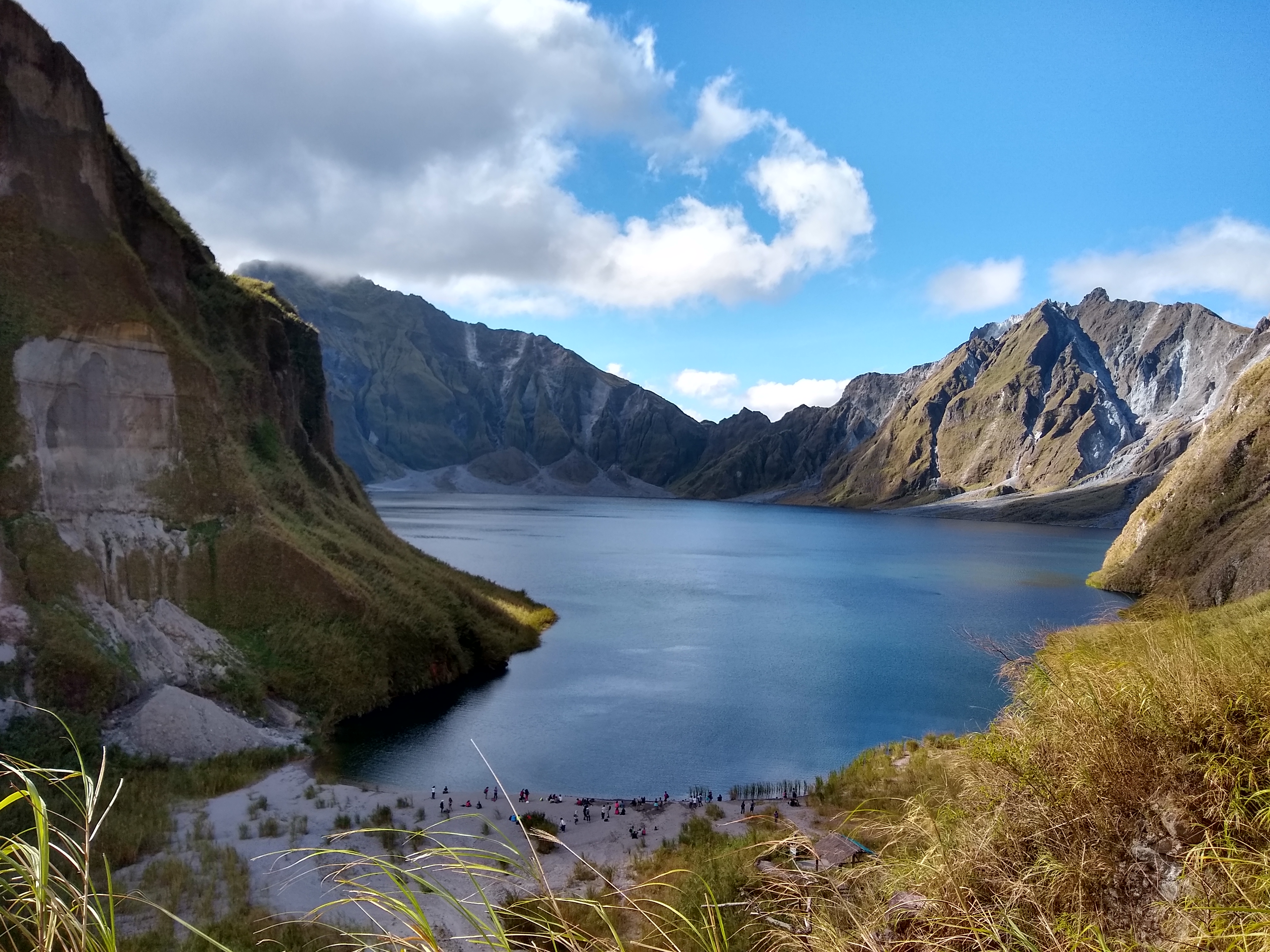
Lake Pinatubo
The Aeta people have a legend about a lake that once existed at the summit of the mountain. Then came a great explosion, and the lake was destroyed. On June 15, 1991, that legend repeated itself in reverse: Mount Pinatubo's climactic eruption blew away its own peak, and within months, rain began filling the 2.5-kilometer-wide caldera left behind. What started as a shallow, scalding pool of acidic water has since become one of the most striking crater lakes in Southeast Asia, its waters shifting between emerald and turquoise depending on the light and the season.
Born from Catastrophe
The 1991 eruption destroyed Mount Pinatubo's original summit and left a caldera whose center sits roughly one kilometer north of where the peak used to be. The collapse happened during a period of massive earthquakes as magma drained from the reservoir deep beneath the volcano. By early September 1991, just weeks after the eruption, a shallow lake had already begun to form. The high rainfall of central Luzon accelerated the transformation from a small, hot, acidic pool into a large body of water with near-ambient temperature and pH. Located in the Zambales Mountains about 90 kilometers northwest of Manila, the lake sits at the junction of Zambales, Pampanga, and Tarlac provinces. Geophysical surveys show that at least two ancient lakes existed in the Mapanuepe River valley on the volcano's southwestern slopes, evidence that Pinatubo has followed this cycle before: eruption, collapse, water, and long silence.
A Threat That Kept Growing
For years after the eruption, the lake's rising water level posed a serious danger to communities below. The water climbed roughly one meter per month, and experts feared its sheer weight could breach the crater walls and unleash a catastrophic flood on the coastal town of Botolan, 25 miles away, where up to 40,000 people lived in the danger zone. In September 2001, residents of Botolan and surrounding areas were evacuated as a precaution. The Philippine government ordered a controlled draining operation, carving a five-meter-wide channel from the crater's edge to release about a quarter of the lake's volume into local rivers. But the monsoons kept coming. In 2002, accumulated rainwater overwhelmed the drainage canal, triggering lahar flows through the network of canyons that scar the volcano's flanks, the largest draining into the Bucao River. The mountain was still very much alive, not through fire, but through water.
The Aeta and the Mountain
The Zambales Mountains have been home to the indigenous Aeta people for centuries. Their oral traditions include the legend of a lake that once existed at this very site, most likely one of the ancient crater lakes that formed during earlier eruptive cycles. The story describes a great explosion that destroyed that earlier lake. When modern Pinatubo erupted, it displaced thousands of Aeta families from their ancestral forests. In 2009 and 2010, the Philippine government began granting Certificates of Ancestral Domain Title to Aeta communities, formally recognizing their ownership of lands on both the Pampanga and Zambales sides of the volcano, including the summit and the lake itself. The Aeta call this their lutan tua, their ancestral land, a recognition that came only after the eruption had already scattered their communities across the lowlands.
A Jewel Worth the Trek
Visitors describe Lake Pinatubo as a wide jewel of blue and green, and reaching it requires effort. In the early years, the journey meant days of hiking or hours of rough four-wheel-drive travel followed by a two-hour climb. The construction of a route called the Skyway eventually shortened the approach, allowing vehicles to reach a drop-off point from which the final trek to the crater takes about an hour. The lake draws mountaineers and adventure-seekers who make the pilgrimage through lahar-carved terrain to stand on the rim and look down at the improbably vivid water below. The caldera's shape even inspired the design of the New Clark City Athletics Stadium in nearby Capas, Tarlac. What was once a zone of destruction has become a destination, proof that the earth can create beauty from its most violent acts.
From the Air
Lake Pinatubo sits at approximately 15.13N, 120.35E within the Zambales Mountains of Luzon, Philippines. The turquoise crater lake is clearly visible from altitude within the 2.5 km caldera. Nearest major airport is Clark International Airport (RPLC), about 40 km east. Subic Bay International Airport (RPLB) lies 37 km to the south. Maintain safe altitude above surrounding peaks reaching 1,745 m. Mountain weather can change rapidly with frequent cloud cover, especially during monsoon season.