Lake Superior Provincial Park
The autumn light hits Old Woman Bay at a low angle, and suddenly you understand why Lawren Harris stood here with a canvas. The southern maples blaze orange and crimson while the boreal spruce behind them hold their dark green, and the two forest types collide in a color riot that stretches along the Lake Superior shore for over a hundred kilometers. Lake Superior Provincial Park was created in 1944 after residents of Sault Ste. Marie demanded protection for this stretch of coast, and what they preserved is a landscape that feels more like the edge of the known world than a park with campgrounds and trail maps. The rock is ancient. The lake is enormous. The weather changes without warning. This is Northern Ontario at its most dramatic.
Billion-Year Bones
The park's geology reads like a compressed textbook of Earth's deep history. The high, rounded hills are the stumps of ancient mountain ranges, ground down by successive glaciers and blanketed with glacial sediment. Granite and gneisses form the bedrock -- some of the oldest exposed rock on the planet, part of the Canadian Shield that underpins much of Canada. Lava rock from Precambrian volcanic eruptions juts along the shoreline alongside diabase dykes, while relatively young Cambrian sandstone adds a final geological layer. Faulting shaped the most dramatic features: Agawa Canyon, Agawa Rock, and the sweeping amphitheater of Old Woman Bay. Rivers cascade from the highlands to the coast, dropping rapidly through rapids and waterfalls. The landscape is raw and sculptural, every cliff face and river channel a record of forces operating across unimaginable spans of time.
Painted by Masters
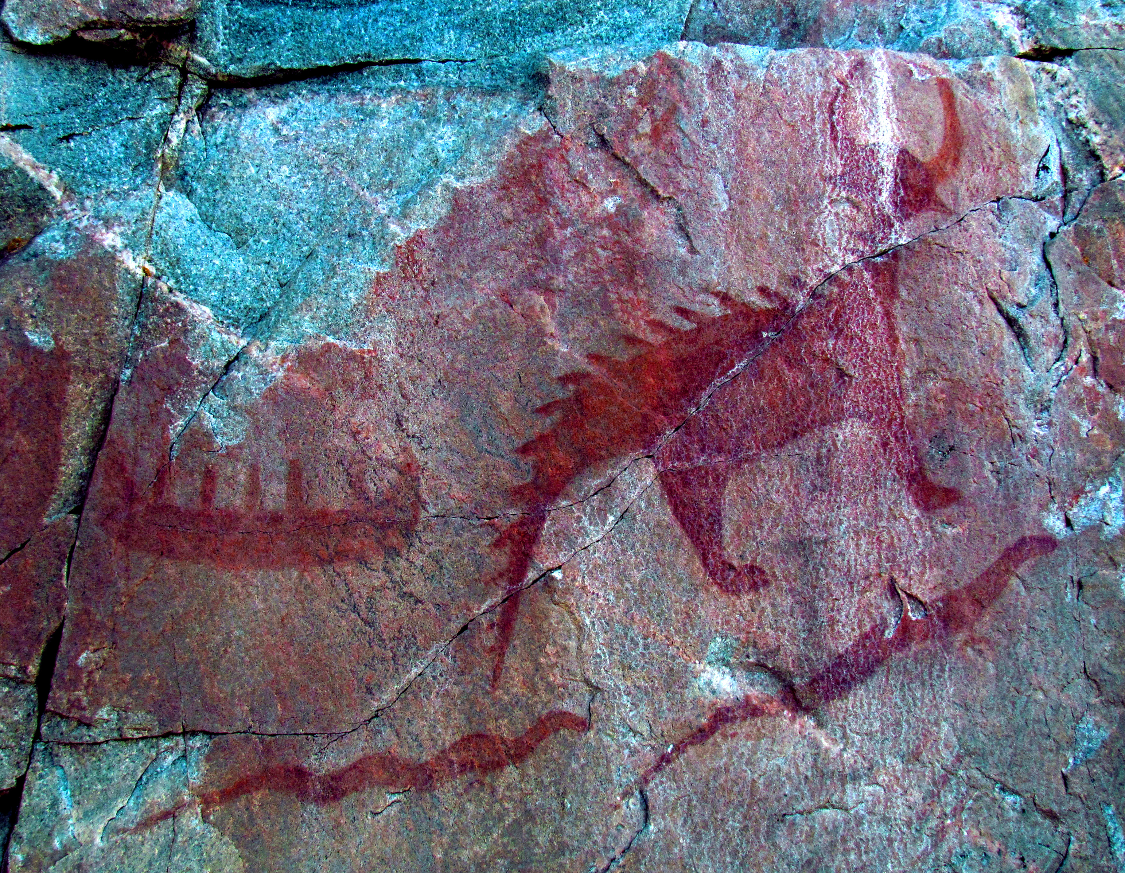
The Group of Seven artists who traveled into the Algoma backcountry in the early twentieth century found in this landscape a subject worthy of a national art movement. The mist-shrouded hills, the deep canyons, the autumn forest ablaze against Superior's steel-grey waters -- these became the raw material for some of Canada's most iconic paintings. But the park holds older art, too. At Agawa Rock, Indigenous pictographs painted in red ochre depict canoes, serpents, and spiritual figures on a sheer cliff face above the lake. Park interpreters guide visitors to the pictographs and discuss their natural and cultural context. The visitor centre at Agawa Bay documents both stories -- the ancient Indigenous presence and the later artistic heritage -- along with the region's fur trade history and the shipwrecks that litter Superior's eastern shore.
The Coastal Trail
The park's crown jewel is the Coastal Trail, widely considered some of the most spectacular hiking in Ontario. The route follows the Lake Superior shoreline through rugged terrain that takes five to seven days to complete. Backcountry campsites sit on secluded bays, and the stretch north of Katherine Cove -- away from the Trans-Canada Highway -- is the most peaceful and the most physically demanding. Eleven trails in total range from half-hour walks to multi-day expeditions. The Orphan Lake Trail offers a moderate eight-kilometer loop with varied terrain. Canoe routes wind through the park interior, ranging from easy flatwater to challenging whitewater stretches, and paddlers can access the eastern reaches by loading canoes onto the Algoma passenger trains. The park sits between Sault Ste. Marie and the small town of Wawa along Highway 17, the Trans-Canada, making it one of the most accessible true wilderness areas in the province.
Wild Residents
More than 250 bird species have been documented within the park boundaries, with 120 species nesting there. Great blue herons patrol the shoreline, loons call across the interior lakes, and warblers fill the boreal understory. The larger mammals are here too -- moose are commonly sighted, along with timber wolves, Canada lynx, black bears, and white-tailed deer, though the deer struggle with the deep snow and severe winters at this latitude. Smaller residents include red fox, beaver, marten, and red squirrels. The lake itself holds strong populations of lake and rainbow trout, whitefish, and three species of salmon. In winter, the park gates close to vehicles but remain open to skiers, snowshoers, and ice fishers willing to brave conditions that can be genuinely unforgiving. Cell service is spotty to nonexistent, help is far away, and the park's own website advises visitors to bring a companion.
From the Air
Lake Superior Provincial Park stretches along the eastern shore of Lake Superior at approximately 47.597N, 84.741W, between Sault Ste. Marie (120 km south) and Wawa (20 km north) along Highway 17. From the air, the park's most striking features are Old Woman Bay, a dramatic horseshoe-shaped inlet, and the Agawa River canyon cutting inland through boreal forest. The Coastal Trail traces the shoreline and is visible as a thin path along the cliff edges. The nearest airport is Sault Ste. Marie Airport (CYAM), approximately 120 km to the south. Fly at 2,000-3,000 feet AGL for the best views of the shoreline cliffs and autumn colors. The transition between deciduous and boreal forest creates a distinctive patchwork visible from altitude, particularly dramatic in late September and early October.