Glacially eroded outcrop of jaspilite banded iron formation in the Precambria of Minnesota.
The Soudan Iron-Formation is a Neoarchean-aged banded iron formation (BIF) unit in the Vermilion Greenstone Belt of northeastern Minnesota, USA.  Stratigraphically, the Soudan is considered to be the middle member of the Ely Greenstone.  Metamorphosed pillow basalt successions occur above and below the iron-rich interval:
- upper member of the Ely Greenstone
- Soudan Iron-Formation member
- lower member of the Ely Greenstone
Radiometric dating of Ely Greenstone rocks (see Jahn & Murthy, 1975) indicate that the Soudan Iron-Formation is about 2.69 billion years old.
The Soudan Iron-Formation was deposited in a deep-water environment and is closely associated with several types of volcanic rocks formed in an ancient island arc setting.  As such, the unit is classified as an Algoma-type iron-formation.  Superior-type iron-formations were deposited in relatively shallow water, continental shelf settings.
The Soudan Iron-Formation is exposed in & around the town of Soudan, Minnesota at roadcuts, glacially-eroded outcrop knobs, surface mines, and underground mines.  The best exposures are at Soudan Underground Mine State Park.  The Soudan Mine targeted high-grade iron ore (specularite) for many decades and closed in the early 1960s.  The site is now accessible to the public and underground tours are offered.
Observed iron-rich lithologies in the Soudan Iron-Formation include specularite, jaspilite BIF, and magnetite BIF.
The above photo is part of a glaciated knob of jaspilite BIF in Soudan Mine Park.  The outcrop is glacially smoothed and striated.  The rocks here are faulted and complexly folded.  Folding occurred in two phases - some of it occurred during soft-sediment deformation events and subsequent structural folding occurred after the rocks were lithified.  The light-colored layers are chert (= microcrystalline to cryptocrystalline quartzose sedimentary rock), the red layers are "jasper" (= hematite-rich chert), and the silvery-gray layers are magnetite-chert.  A detailed description of this outcrop occurs in Huda et al. (2008).
Stratigraphy: Soudan Iron-Formation member, Ely Greenstone, Vermilion Greenstone Belt, Neoarchean, ~2.69 Ga
Locality: glaciated outcrop now adjacent to Stuntz Bay Road in Soudan Underground State Park, Soudan, northern St. Louis County, northeastern Minnesota, USA (47° 49' 14.82" North, 92° 14' 11.84" West)


References cited:
Huda et al. (2008) - Field Guide to the Volcanology, Structure, Alteration, and Mineralization of Archean Greenstone Belts in the Vicinities of Sturgeon Lake and Rainy River, Ontario and Lake Vermilion, Minnesota, October 5-12, 2008, Field Trip Guidebook.  209 pp.

Jahn & Murthy (1975) - Rb-Sr ages of the Archean rocks from the Vermilion District, northeastern Minnesota.  Geochimica et Cosmochimica Acta 39: 1679-1689.
Glacially eroded outcrop of jaspilite banded iron formation in the Precambria of Minnesota. The Soudan Iron-Formation is a Neoarchean-aged banded iron formation (BIF) unit in the Vermilion Greenstone Belt of northeastern Minnesota, USA. Stratigraphically, the Soudan is considered to be the middle member of the Ely Greenstone. Metamorphosed pillow basalt successions occur above and below the iron-rich interval: - upper member of the Ely Greenstone - Soudan Iron-Formation member - lower member of the Ely Greenstone Radiometric dating of Ely Greenstone rocks (see Jahn & Murthy, 1975) indicate that the Soudan Iron-Formation is about 2.69 billion years old. The Soudan Iron-Formation was deposited in a deep-water environment and is closely associated with several types of volcanic rocks formed in an ancient island arc setting. As such, the unit is classified as an Algoma-type iron-formation. Superior-type iron-formations were deposited in relatively shallow water, continental shelf settings. The Soudan Iron-Formation is exposed in & around the town of Soudan, Minnesota at roadcuts, glacially-eroded outcrop knobs, surface mines, and underground mines. The best exposures are at Soudan Underground Mine State Park. The Soudan Mine targeted high-grade iron ore (specularite) for many decades and closed in the early 1960s. The site is now accessible to the public and underground tours are offered. Observed iron-rich lithologies in the Soudan Iron-Formation include specularite, jaspilite BIF, and magnetite BIF. The above photo is part of a glaciated knob of jaspilite BIF in Soudan Mine Park. The outcrop is glacially smoothed and striated. The rocks here are faulted and complexly folded. Folding occurred in two phases - some of it occurred during soft-sediment deformation events and subsequent structural folding occurred after the rocks were lithified. The light-colored layers are chert (= microcrystalline to cryptocrystalline quartzose sedimentary rock), the red layers are "jasper" (= hematite-rich chert), and the silvery-gray layers are magnetite-chert. A detailed description of this outcrop occurs in Huda et al. (2008). Stratigraphy: Soudan Iron-Formation member, Ely Greenstone, Vermilion Greenstone Belt, Neoarchean, ~2.69 Ga Locality: glaciated outcrop now adjacent to Stuntz Bay Road in Soudan Underground State Park, Soudan, northern St. Louis County, northeastern Minnesota, USA (47° 49' 14.82" North, 92° 14' 11.84" West) References cited: Huda et al. (2008) - Field Guide to the Volcanology, Structure, Alteration, and Mineralization of Archean Greenstone Belts in the Vicinities of Sturgeon Lake and Rainy River, Ontario and Lake Vermilion, Minnesota, October 5-12, 2008, Field Trip Guidebook. 209 pp. Jahn & Murthy (1975) - Rb-Sr ages of the Archean rocks from the Vermilion District, northeastern Minnesota. Geochimica et Cosmochimica Acta 39: 1679-1689.

Lake Vermilion-Soudan Underground Mine State Park

miningstate-parkminnesotairon-rangephysicsnational-historic-landmarkunderground
4 min read

Visitors step into a 1924 electric mine cage and drop nearly half a mile straight down. At level 27 -- 2,341 feet below the surface of northern Minnesota -- the air is cool and still, the rock walls are 2.69 billion years old, and cosmic rays barely penetrate. This is the Soudan Mine, the oldest and deepest iron mine in Minnesota, where prospectors once pulled hematite so pure it contained more than 65 percent iron, and where, decades after the last ore car rolled, University of Minnesota physicists built detectors to search for neutrinos and dark matter. The mine is now the centerpiece of Lake Vermilion-Soudan Underground Mine State Park, a National Historic Landmark on the south shore of Lake Vermilion in the Vermilion Range.

Gold Seekers, Iron Finders

The prospectors who arrived in the late 19th century were looking for gold. What they found was far more valuable to an industrializing nation: extremely rich veins of hematite, the iron ore that would feed the blast furnaces of Pittsburgh and Chicago. An open pit mine began operating in 1882. By 1900, safety concerns pushed operations underground. The Soudan Mine became part of United States Steel Corporation's Oliver Iron Mining division in 1901 and remained in production until 1962. During those six decades, miners drove more than fifty miles of drifts, adits, and raises through the Precambrian Shield. The mining method -- cut and fill -- was elegantly suited to the geology. Miners excavated the ceiling and used waste greenstone to raise the floor at the same rate, keeping the working space always between ten and twenty feet high. No waste rock needed to be hauled to the surface. When the mine finally closed, level 27 was still being developed at 2,341 feet below ground.

Deeper Than Daylight Reaches

In the 1980s, the University of Minnesota recognized something valuable about the Soudan Mine beyond its ore: depth. At 2,341 feet underground, the cosmic ray rate drops to a whisper. That silence made the mine ideal for physics experiments that require extreme shielding from background radiation. The Soudan 1 proton decay experiment moved in first, followed by Soudan 2, which ran from 1989 to 2001. Then came the heavy hitters: the MINOS neutrino detector, which received a beam of neutrinos fired from Fermilab in Illinois, 456 miles away; dark matter search experiments CDMS-II, SuperCDMS, and CoGeNT; and facilities for electroforming ultra-pure, radiation-free copper. The scientists could use the mine's still-operational 1924 hoist to reach their instruments -- the same cage that now carries tourists. The underground laboratory closed around 2016, and public tours of the physics facilities are no longer offered.

Fire in the Shaft

On the night of March 17, 2011, fire broke out in the main shaft at the 25th level. Responders smothered it by pumping 70,000 gallons of firefighting foam into the lowest levels, filling the 27th level from floor to ceiling. The underground physics laboratory lost power but remained structurally safe. Mine tours shut down for the entire summer of 2011, though above-ground exhibits and the interpretive center reopened. A major cleanup effort followed, and underground tours resumed on May 26, 2012. The fire demonstrated both the hazards of maintaining infrastructure half a mile underground and the determination to keep this unique site accessible. Underground tours have since been intermittently suspended as the park continues to manage the aging mine infrastructure.

Two Parks Become One

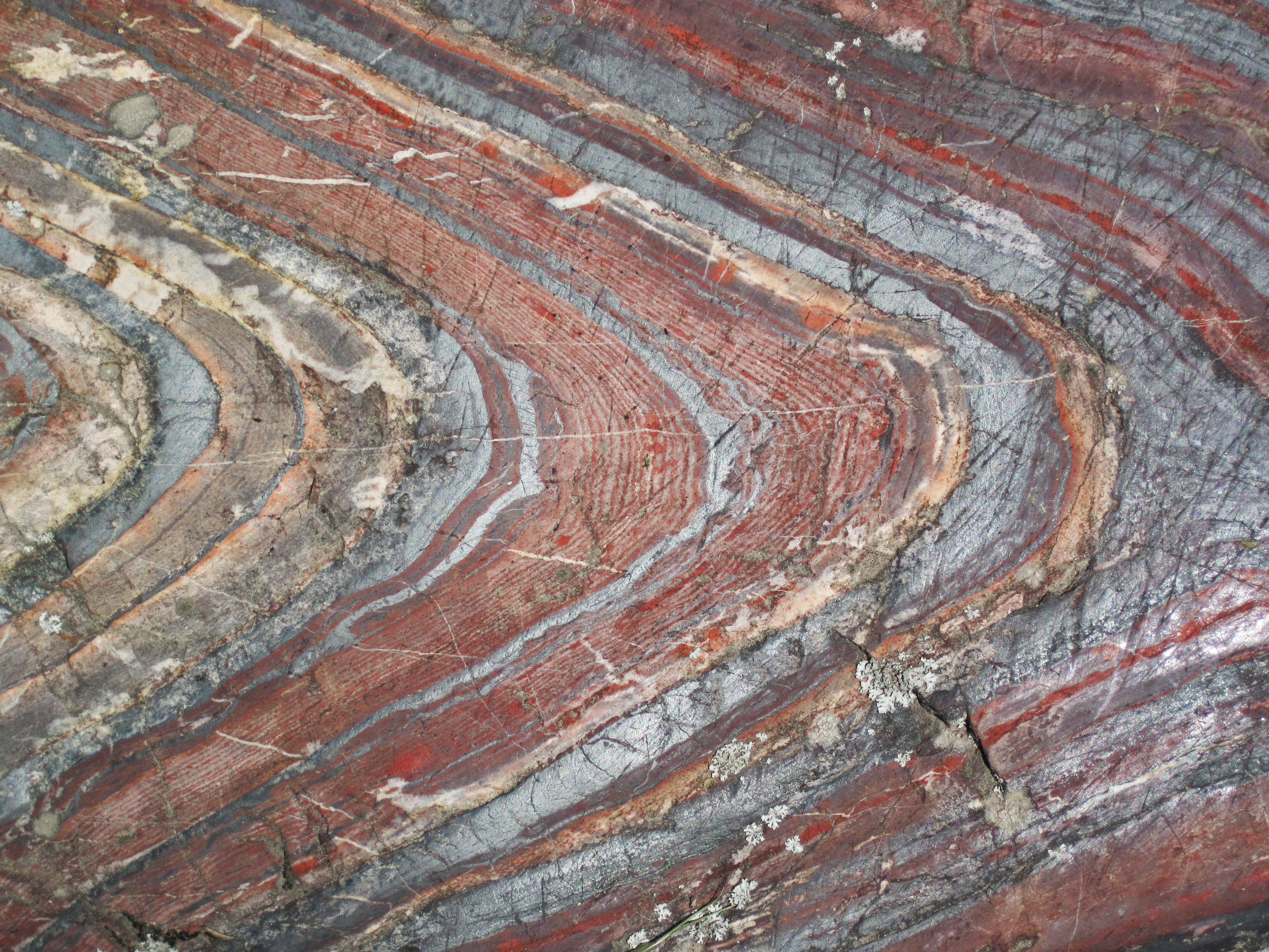
For years, Soudan Underground Mine State Park stood as its own entity. Then in 2010, the State of Minnesota purchased about 3,000 acres from U.S. Steel along the south shore of Lake Vermilion to create a separate Lake Vermilion State Park. The new parkland included the Stuntz Bay Boathouse Historic District, a collection of early 20th-century boathouses that offer their own window into the region's recreational past. In 2014, the two adjacent parks merged into the single Lake Vermilion-Soudan Underground Mine State Park. Today the combined park draws visitors heading to and from Ely and the Boundary Waters Canoe Area Wilderness. They come to ride the antique cage into the depths, to walk the shores of Lake Vermilion, and to stand before surface outcrops of folded Soudan Iron Formation -- rock 2.69 billion years old, scarred by glacial scratches -- that began this whole story of extraction, science, and preservation.

From the Air

Located at 47.82N, 92.24W on the south shore of Lake Vermilion in northern Minnesota's Vermilion Range. The mine headframe is visible from low altitude near the town of Soudan, adjacent to Tower. Lake Vermilion is a large, multi-armed lake stretching roughly 40 miles and easily recognizable from the air. The nearest airports include Tower Municipal Airport (unrestricted field) immediately adjacent, Range Regional Airport (KHIB) in Hibbing about 45 miles southwest, and Eveleth-Virginia Municipal Airport (KEVM) about 30 miles south. The Boundary Waters Canoe Area Wilderness lies to the north and east. Terrain is gently rolling boreal forest with no significant elevation hazards. Best viewed at 3,000-6,000 feet for mine site and lake detail.