Latourell Falls
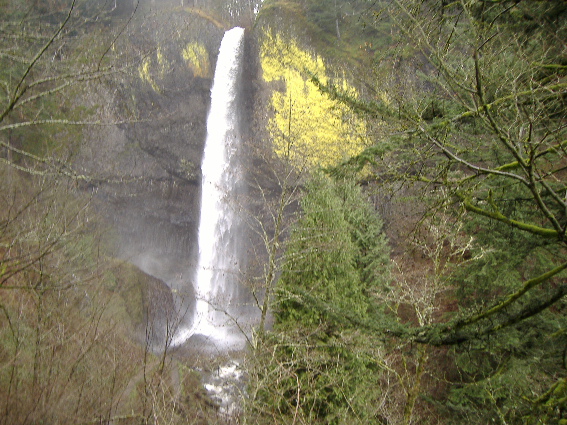
Most waterfalls tumble. Even the famous ones, even Multnomah Falls with its postcard-perfect tiers, involve water cascading down rock faces, bouncing, spreading, making contact along the way. Latourell Falls does something different. Here, the water launches itself from an overhanging basalt cliff and falls straight down, a clean vertical plunge through open air before striking the pool below. No tumbling, no cascading, no contact with rock until the very end. This is not how waterfalls typically behave, and it is precisely this geometric purity that sets Latourell apart in a gorge famous for its cascades. The falls sit within Guy W. Talbot State Park, visible from certain stretches of the Historic Columbia River Highway, accessible via a short path from a parking lot near the base.
Geometry of the Plunge
What makes Latourell Falls unique among the Columbia Gorge waterfalls is geometry. The basalt cliff from which the water falls does not slope or step; it overhangs. The water leaves the lip of the cliff already falling, already separated from the rock face, and continues that separation all the way down. This creates a visual effect quite different from the typical cascade, where water appears to cling to and flow down the rock surface. At Latourell, you see daylight between the falling water and the cliff behind it, a clean line of separation maintained through the entire drop. It is the difference between pouring and sliding.
Columns of Ancient Fire
The cliff face at Latourell Falls presents one of the finest examples of columnar basalt in the Columbia River Gorge. These distinctive hexagonal columns formed millions of years ago when vast flows of lava cooled slowly and cracked in patterns that geologists find endlessly fascinating. The columns create the vertical, geometric texture visible behind and beside the falling water, a backdrop of ancient volcanic rock that underscores just how long water has been carving through this landscape. The formations here are so well-defined, so clearly visible, that geology textbooks have used Latourell as an illustration of what columnar basalt looks like.
Upper and Lower
Latourell Creek actually produces two waterfalls. The lower falls, the famous one, sits near the highway and parking area, easily reached by a short walk. But visitors willing to hike the loop trail, roughly two and a half miles, can reach the upper falls as well. The contrast between the two rewards the effort: while the lower falls demonstrates that perfect vertical plunge, the upper falls takes a different character entirely. Together, they illustrate how the same creek, flowing through the same geological formations, can produce dramatically different cascades depending on the exact shape of the rock it encounters.
A Bridge Below the Falls
The Latourell Creek Bridge sits below the falls, carrying the Historic Columbia River Highway across the creek. This structure holds double historical distinction: it is both a contributing structure in the highway's listing on the National Register of Historic Places and part of the highway's designation as a National Historic Landmark. The bridge represents the early twentieth century's ambitious effort to open the Columbia River Gorge to automobile tourism, an engineering project that required building roads and bridges in terrain that seemed to resist human infrastructure at every turn. That the bridge survives, functional and largely unchanged, speaks to the quality of its original construction.
Easily Reached, Deeply Impressive
Unlike some of the Gorge's more remote waterfalls, Latourell Falls rewards visitors who may have limited time or mobility. The lower falls can be seen from portions of the Historic Columbia River Highway, and the path from the parking lot to the base viewpoint is brief. This accessibility has made Latourell a favorite stop for those driving the scenic highway, a place where you can stretch your legs, feel the mist on your face, and witness something genuinely remarkable without committing to a lengthy hike. Yet for those who want more, the loop trail to the upper falls awaits, proving that easy access does not preclude deeper exploration.
From the Air
Latourell Falls is located at coordinates 45.5371N, 122.2169W within Guy W. Talbot State Park in the Columbia River Gorge, at approximately 250 feet elevation. The falls are visible from the air as a thin white vertical line against the dark columnar basalt cliff face, distinctive for its straight plunge rather than cascading flow. The Historic Columbia River Highway passes nearby with a bridge crossing Latourell Creek below the falls. Nearest airports include Portland International (KPDX, 22nm west) and Troutdale Airport (KTTD, 12nm west). The falls mark the western end of the Gorge's concentrated waterfall corridor.