Lauwersmeer
On 25 May 1969, Dutch engineers dropped the last section of dike across the mouth of the Lauwers Sea, and a tidal bay that had existed since a great flood in 1280 stopped being part of the sea. The water still moved, but only because the wind pushed it. The salt stopped coming in. Within a few years the bottom of the bay was rinsed clean by the rivers feeding it, the salt-marsh grasses died, freshwater reeds came in, and the Lauwers Sea became the Lauwersmeer, a Dutch suffix change of one letter that marked a complete ecological identity swap. Local people had fought the closure. They collected 135,000 signatures asking the government to choose the more expensive option of reinforcing the existing 32 kilometers of dikes rather than building a new 13-kilometer dam. They lost. The dam was cheaper. The bay became a lake.
A Flood Made the Bay
The Lauwers Sea was itself an accident. Before 1280 it did not exist. There was a river called the Lauwers running through the wet northern country toward the Wadden Sea, and there was farmland along it. Then in 1280 a great storm flood came up the coast and tore the river's mouth open, drowning the land on either side and creating a two-forked tidal estuary that swallowed villages. Over the next six centuries, Dutch farmers slowly took pieces of it back, building dikes around the edges and pumping the new polders dry. By the 20th century the original drowned land had shrunk into a roughly square bay still open to the Wadden Sea at its northern end. A flood made it; centuries of patient embanking shrank it; an engineering decision in 1969 sealed it shut.
The Decision That Was Resented
The Christmas flood of 1954, following the catastrophic North Sea flood of 1953, pushed the Dutch government to act on the northern coast. The 1958 Delta Law required the dikes here to be reinforced to a much higher standard. Engineers presented two options: rebuild and raise 32 kilometers of existing perimeter dikes around the Lauwers Sea, or build a single 13-kilometer dam across its mouth and turn the bay into a lake. The dam was cheaper. Local fishermen and the small port towns ringing the bay knew what they would lose: the tidal channels that worked for their boats, the access to the Wadden Sea, the ecology they had built lives around. The actiecomite Lauwerszee gathered 135,000 signatures and held a major rally in Leeuwarden. On 10 June 1960, the De Quay cabinet voted to close the bay anyway. Construction took most of the decade. The closure took effect on 25 May 1969.
What Came After
The new lake did something nobody had quite predicted. As the salt drained out, the bare clay floor exposed by lower water levels turned out to be perfect habitat for pioneer plants, then for grasses, then for breeding waders and migrating geese in numbers that grew year over year. By the 1990s, conservationists were arguing that what had been built as flood infrastructure had accidentally become one of the most important bird sites in the western Netherlands. On 12 November 2003, the central and eastern parts of the lake were designated Lauwersmeer National Park. The Marnewaard on the eastern shore remained, perhaps incongruously, an active training area for the Royal Netherlands Army. The ferry to Schiermonnikoog, the eastern Wadden island, now leaves from Lauwersoog, the new harbor built into the dike itself.
Darkest Sky in the Netherlands
In a country as densely populated and brightly lit as the Netherlands, real darkness is rare. The Lauwersmeer has it. The lake and the surrounding salt marshes form one of the largest unlit areas in the country, and on clear nights without moon the Milky Way is visible here in a way that simply is not possible from almost anywhere else south of Friesland. The national park was certified as a Dark Sky Park in 2016. Volunteers run star-gazing nights from a small observatory near the dike, and amateur astronomers drive up from the Randstad to set up tripods on the polder roads at midnight. The bay that lost its salt and its tide picked up a sky in compensation. It is, on most nights, a quieter trade than the engineers building the dam in 1969 could have imagined defending.
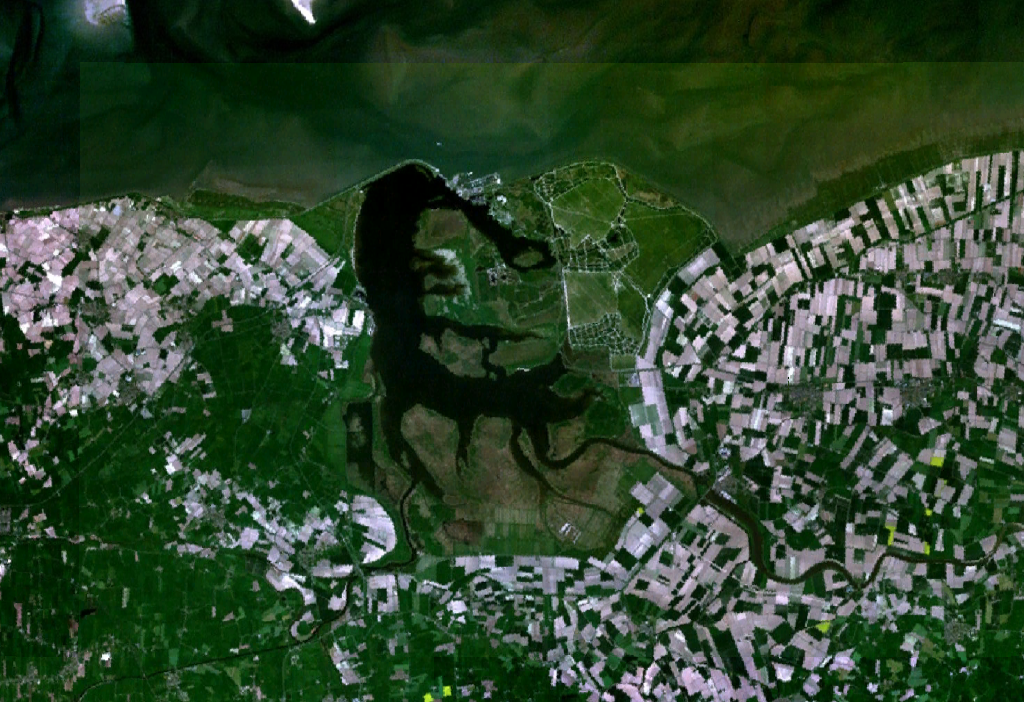
From the Air
Coordinates 53.377N, 6.173E. Lauwersmeer is best viewed from 3,000-5,000 ft AGL on the descent toward Groningen Eelde (EHGG), 35 km southeast. The dam itself, with Lauwersoog harbor punching through it, is unmistakable as the straight line dividing the lake from the Wadden Sea to the north. At low tide the wet mudflats north of the dam glisten silver. Birdlife is intense year-round; military activity at Marnewaard on the eastern shore can prompt temporary restricted airspace. After dark, the area shows up as the largest unlit patch on a satellite view of the western Netherlands.