Liaodong Peninsula
Every empire that wanted Northeast China had to take the Liaodong Peninsula first. This rugged finger of land, stretching south into the Yellow Sea between the Bohai and Korea Bay, has been a strategic prize since the Warring States period -- a corridor for armies, a haven for refugees, and a choke point where the fate of dynasties was decided. Its name means "east of the Liao," a deceptively simple label for a landscape whose history reads like a ledger of conquest.
Where Mountains Meet the Sea
The peninsula divides two bodies of water: Liaodong Bay, the largest inlet of the Bohai Sea, lies to the west, while Korea Bay opens eastward toward the Korean Peninsula. The Qianshan Mountains form the spine of the land, a southern extension of the Changbai range that includes Dahei Mountain near the port city of Dalian. Between the mouths of the Daliao River to the west and the Yalu River to the east, the peninsula encompasses coastline, mountain terrain, and the territories of Dalian, Yingkou, Anshan, and Dandong. From the air, the peninsula appears as a natural bridge -- and that is precisely how conquerors have always treated it.
A Revolving Door of Kingdoms
Neolithic peoples of the Xinle culture were the peninsula's earliest known inhabitants. The Gojoseon kingdom held the region until the State of Yan conquered it in the late 4th century BC, establishing the Liaodong Commandery. What followed was a succession of rulers that mirrors the turbulence of East Asian history itself: the Qin, the Han, the warlord Gongsun clan, Cao Wei, the Western Jin, then a cascade of kingdoms during the chaotic Sixteen Kingdoms period -- Former Yan, Former Qin, Later Yan. Goguryeo held it next, then the Tang dynasty took it back. The Khitan Liao dynasty, the Jurchen Jin, the Mongol Yuan, the Ming, the Qing -- each planted their flag on this same contested ground. The peninsula was less a homeland than a waystation between empires.
Refuge on the Water
In the 1870s, the peninsula's role shifted from military corridor to desperate refuge. The Northern Chinese Famine of 1876-1879 drove hundreds of thousands of starving people from Shandong and Hebei northward. The Qing government, which had long prohibited Han Chinese settlement in the Manchu heartlands, quietly relaxed its ban. In 1876, Chinese officials at Yingkou reported that 600,000 refugees had landed on the Liaodong Peninsula. This mass migration, known as Chuang Guandong -- "braving the pass to the east" -- transformed the demographics of Manchuria forever, concentrating a vast new population on a peninsula that had always been fought over but never quite settled.
The Prize That Changed Hands Twice
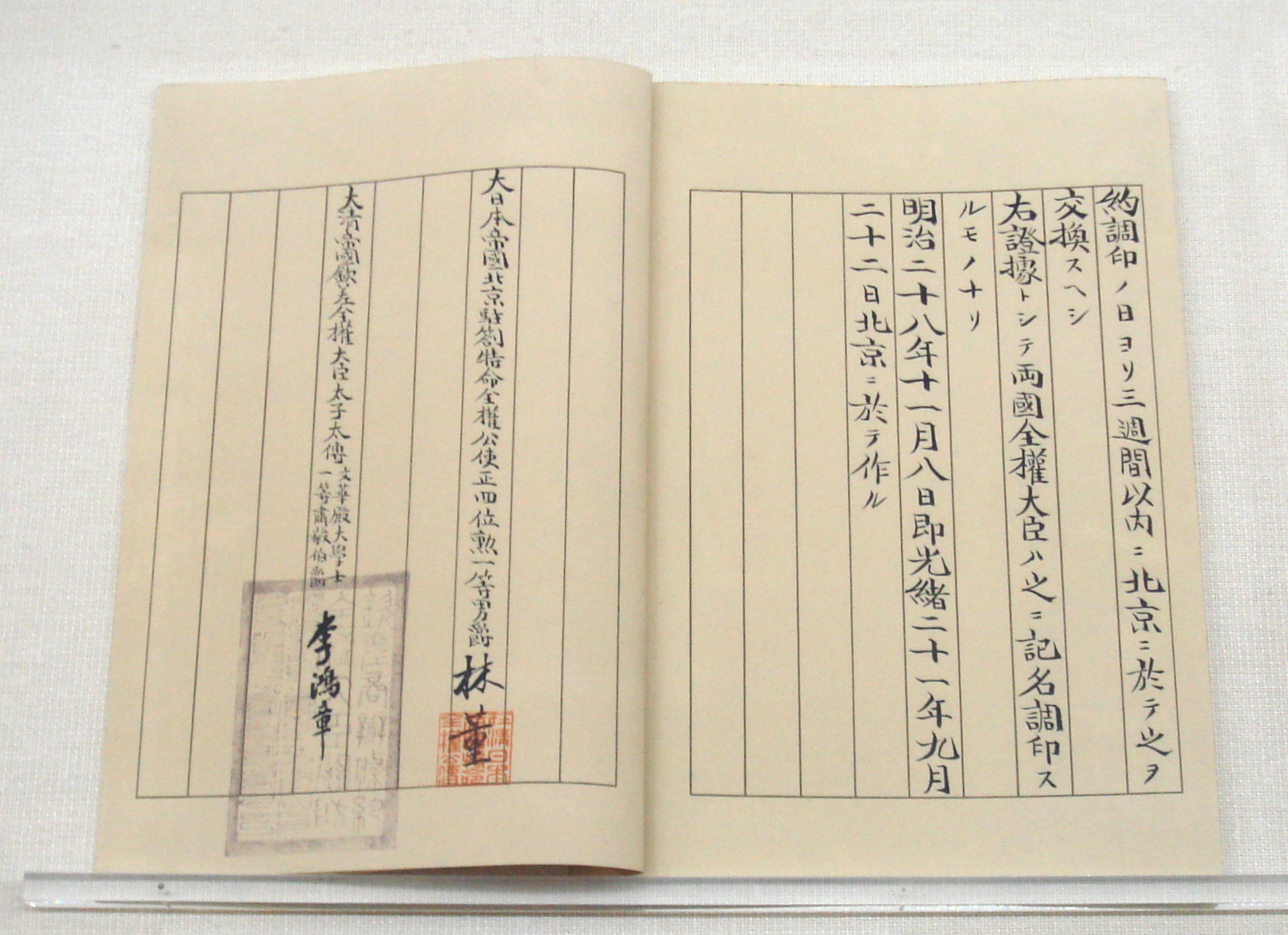
The First Sino-Japanese War of 1894-1895 brought Liaodong into the age of imperial competition. Japan seized the peninsula and extracted it through the Treaty of Shimonoseki in April 1895, along with Taiwan and Penghu. Six days later, Russia, France, and Germany intervened in the so-called Triple Intervention, forcing Japan to return Liaodong to China. Russia then pressured the weakened Qing into leasing the peninsula -- and its strategic port at Lushunkou, known to the West as Port Arthur -- for the Russian Navy. The irony was bitter: Japan had won Liaodong in war only to watch Russia claim it through diplomacy. A decade later, in the Russo-Japanese War of 1904-1905, Japan fought to take back what it felt had been stolen. The Siege of Port Arthur became one of the bloodiest engagements of the early 20th century. The Treaty of Portsmouth transferred the lease to Japan, which administered Liaodong as the Kwantung Leased Territory until the end of World War II.
The Peninsula Today
After Japan's defeat in 1945 and the establishment of the People's Republic of China in 1949, the Liaodong Peninsula returned to unified Chinese sovereignty. Today Dalian, at the peninsula's southern tip, is a major port and economic center, a city of skyscrapers and shipyards that bears little resemblance to the contested fortress it once was. Yet the geography that made Liaodong strategically vital remains unchanged: the narrow corridor between the Bohai Sea and the Korean border, the mountains that funnel movement, the harbors that invite navies. From above, the peninsula still looks like what it has always been -- a gate that swings between worlds.
From the Air
Centered at 40.00N, 122.50E. The peninsula is clearly visible from cruising altitude, extending southward between Liaodong Bay and Korea Bay. Dalian (ZYTL) sits at the southern tip; Shenyang Taoxian (ZYTX) lies to the northeast. Look for the Qianshan mountain ridge running along the peninsula's spine and the coastline curving between the Daliao and Yalu river mouths.