Licancabur
In the Kunza language, lican means "people" and cabur means "mountain." The name fits. Licancabur is not merely a geological feature straddling the Bolivia-Chile border at 5,916 meters; it is a place where human ambition and reverence have climbed alongside each other for centuries. The Inca built ceremonial platforms inside its summit crater. The Atacameno people worshipped it as a living being, married to another peak across the desert. And nestled in that same crater, at an altitude where the air holds barely half the oxygen of sea level, sits a freshwater lake that scientists study because its conditions resemble those believed to have existed on ancient Mars.
The Mountain That Married Another
Atacameno mythology tells of Licancabur and Quimal, a peak in the Cordillera Domeyko, as husband and wife. Together they protect the communities below and fertilize the ground. But Juriques, the volcano to the southeast, coveted Quimal for himself. Licancabur decapitated Juriques in a rage, and the enraged volcano Lascar separated Quimal from her children. Her tears dried into the vast salt flat of the Salar de Atacama. Another legend holds that the mountain entombs a legless Inca king who was carried across the region in a litter. A third says that when the Inca fled colonial invaders, they hid their treasures inside the crater lake, turning its waters bitter and green. Ascending the mountain was taboo. When climbers reached the summit in 1953, locals blamed them for the Calama earthquake that struck the same year.
A Shrine Above the Clouds
The archaeological remains on Licancabur rank among the most complex high-altitude ceremonial sites in the Andes. Inside the eastern part of the summit crater, builders constructed a ceremonial platform and multiple structures in semicircular and rectangular shapes, all assembled pirca-style, without mortar. A stone semicircle surrounding an upright stone resembles an Incan ushnu, or altar. Reports from 1887 and 1955 noted piles of wood hauled to nearly 6,000 meters. At 4,600 meters on the mountain's northeastern flank, Tambo de Licancabur spreads across a 70-meter public square surrounded by over a hundred structures. It served as a gathering place during festivals, a base camp for those who could not make the summit ascent, and likely a waystation on the Inca road linking San Pedro de Atacama to Bolivia. Both Inca and local Atacameno pottery styles have been found at the site.
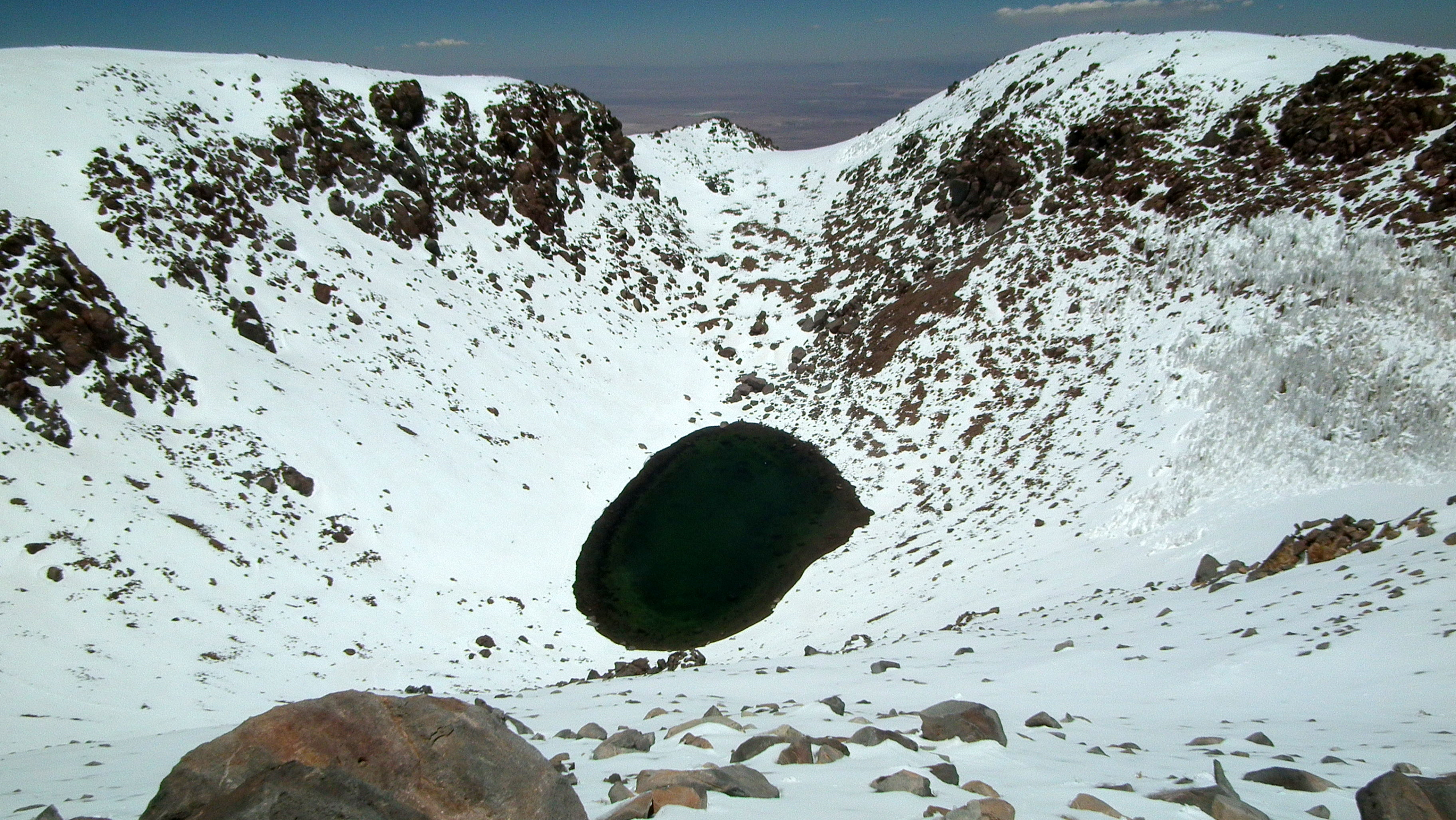
Earth's Stand-In for Mars
The environment around Licancabur may be the closest analog to Mars that exists on Earth. The Atacama Desert, one of the driest places on the planet, delivers punishing ultraviolet radiation, extreme temperature swings, and thin air. Snow cover on the volcano is ephemeral, and no glaciers cling to its slopes despite the altitude. Yet life persists. Cushion plants and tussocks grip the ground above 3,850 meters. Vicuna, guanaco, and Andean hairy armadillo roam below. In the summit crater, the freshwater lake holds conditions researchers believe mirror those of ancient Martian lakes, making Licancabur a testing ground for techniques that might one day search for life on another planet. The Bolivian side of the mountain falls within the Eduardo Avaroa Andean Fauna National Reserve, protecting a landscape where lizards, finches, and even chinchillas have adapted to an altitude that would stagger most mammals.
Fire Beneath the Symmetry
Licancabur's steep, uneroded cone rises in near-perfect symmetry, a shape owed to the highly viscous andesite lavas that built it during the late Pleistocene and Holocene. Three generations of lava flows are visible, the youngest of which spill black-grey tongues as far as 15 kilometers from the summit. No historical eruptions are recorded, and the preservation of Inca ruins on the summit implies the volcano has been quiet for at least 600 to 1,000 years. But elevated temperatures inside the crater suggest residual heat still churns below. Chile's geological survey ranks it 68th among the country's 87 most dangerous volcanoes, a low-hazard designation that owes less to the volcano's temperament than to its remoteness from any settlement. Beneath it all, the Altiplano-Puna Magma Body, a colossal magma chamber stretching under much of the southern Altiplano, connects Licancabur to forces operating on a continental scale.
The View from Six Thousand Meters
Climbers typically approach from the Bolivian side, following a route that takes about six hours up and three down. The first documented ascent belongs to Severo Titichoca in November 1884, though the Inca and Atacameno people reached the summit centuries earlier, as evidenced by the ruins they left behind. Poor weather can close in quickly, and the upper cone's slopes are notoriously unstable. From the top, the panorama takes in Laguna Verde shimmering at the volcano's northeastern foot, the white expanse of the Salar de Atacama to the southwest, and the chain of Andean volcanoes marching northward through Sairecabur and beyond. On clear days, the Llano de Chajnantor Observatory is visible to the southeast, positioned in a region that may receive the highest solar radiation on Earth. It is a view that connects deep geological time with the human impulse to climb, worship, and understand.
From the Air
Licancabur sits at 22.83°S, 67.88°W on the Bolivia-Chile border at 5,916 m (19,409 ft). The volcano's symmetrical cone is a striking visual landmark from any altitude. Laguna Verde lies at the northeastern base. Nearest airports include El Loa Airport (SCCF) at Calama, approximately 150 km to the west. Expect clear skies in the dry season but beware of mountain wave turbulence and rapidly changing conditions. The Salar de Atacama sprawls to the southwest, offering a massive visual reference.