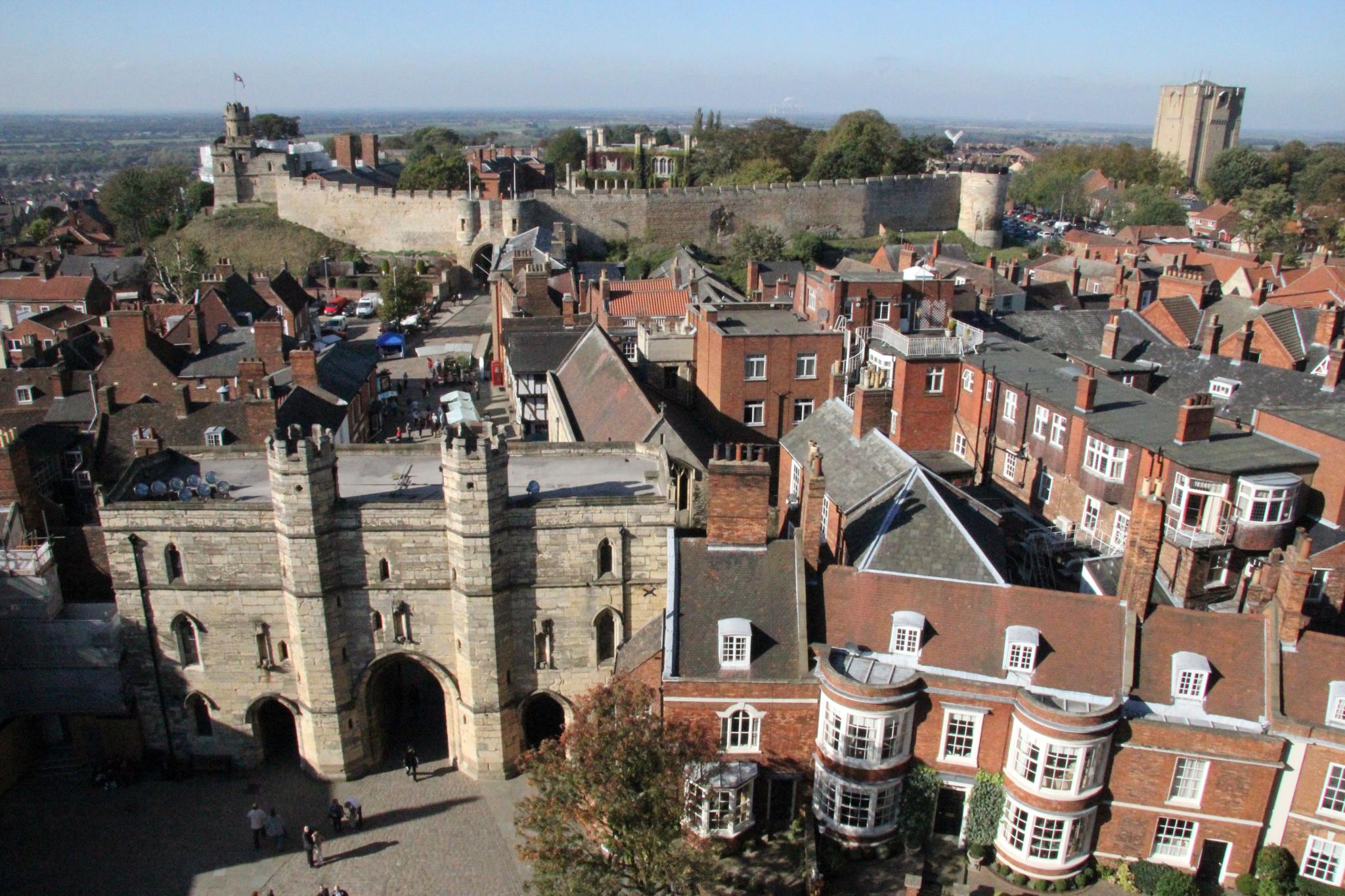
Lincoln Castle
To build his castle at Lincoln, William the Conqueror demolished 166 houses. The Domesday Book records the number precisely -- 'unoccupied residences,' it calls them, cleared to make room on the hilltop where the Roman fortress of Lindum Colonia had stood for a thousand years. William kept the Roman walls. He built his Norman fortification on top of them, incorporating the ancient stone into ramparts and curtain walls. Then he did something found at only one other castle in England: he built two mottes. Two great earthen mounds, each crowned with a tower, rising above the walls on the southern side. Nobody is entirely certain why. The result was a fortress that dominated not just a city but an entire strategic crossroads -- the point where Ermine Street crossed the Fosse Way, where the River Witham connected to the Trent, and where anyone wanting to control the route between London and York had to pass.
The Crossroads of England
William reached Lincoln in 1068, two years after Hastings, and found a Viking trading centre of six to eight thousand people. The old Roman fortress sat 60 metres above the surrounding countryside, commanding views in every direction. It was an ideal strategic position for a castle intended to project Norman power into the Danelaw -- the region of eastern England that had been under Scandinavian control. Lincoln sat at the intersection of England's most important routes: Ermine Street running north to York, the Fosse Way angling southwest to Leicester and Exeter, the River Trent valley opening westward, and the River Witham connecting to the sea via the Wash. William built his castle as part of a network of strongholds across the Midlands -- Cambridge, Huntingdon, Nottingham, Warwick, York -- each designed to hold down the newly conquered territory. The initial structure was probably a wooden keep, later replaced in stone.
Two Battles, One Document
Lincoln Castle was besieged twice. The First Battle of Lincoln, on 2 February 1141, was part of the struggle between King Stephen and Empress Matilda for the English crown. The second siege came on 20 May 1217, during the First Barons' War that followed the sealing of Magna Carta. After that battle, new barbicans were added to the east and west gates. The castle's connection to Magna Carta runs deeper than the fighting that followed it: Lincoln holds one of only four surviving copies of the original 1215 document, sealed by King John after his meeting with the barons at Runnymede. The Lucy Tower, built in the 12th century on the southwestern motte, is named after Lucy of Bolingbroke, Countess of Chester. The Observatory Tower, a square structure on the southeastern motte, stands above the outer walls, dominating the city skyline alongside the cathedral that rises just across the road.
Prison, Chapel, and the Long Drop
Like many English castles, Lincoln found a second life as a prison. A gaol was built within the walls in 1787 and extended in 1847. The prison chapel, still open to visitors, is claimed to be the only one in the world designed for the separate system -- a Victorian innovation in which each seat was enclosed by high wooden partitions, preventing prisoners from seeing or communicating with anyone except the chaplain. The system was intended to encourage moral reflection. Whether it achieved this is debatable. William Marwood, the 19th-century executioner who pioneered the 'long drop' method of hanging -- designed to break the neck rather than strangle -- carried out his first execution here in 1872, dispatching Fred Horry. Until 1868, hangings were conducted publicly from a mural tower at the northeast corner, overlooking the upper town. The Crown Court buildings on the western side of the castle grounds, built in 1823, remain in active use today. Lincoln Castle is one of the few places in England where you can walk medieval walls, view Magna Carta, and pass a functioning courtroom, all within the same perimeter.
From the Air
Lincoln Castle sits at 53.23°N, 0.54°W on the hilltop in the centre of Lincoln, immediately adjacent to Lincoln Cathedral. Both structures dominate the city skyline from altitude. The castle walls and twin mottes are visible from lower altitudes. RAF Waddington is approximately 4nm to the south and RAF Scampton approximately 5nm to the north.