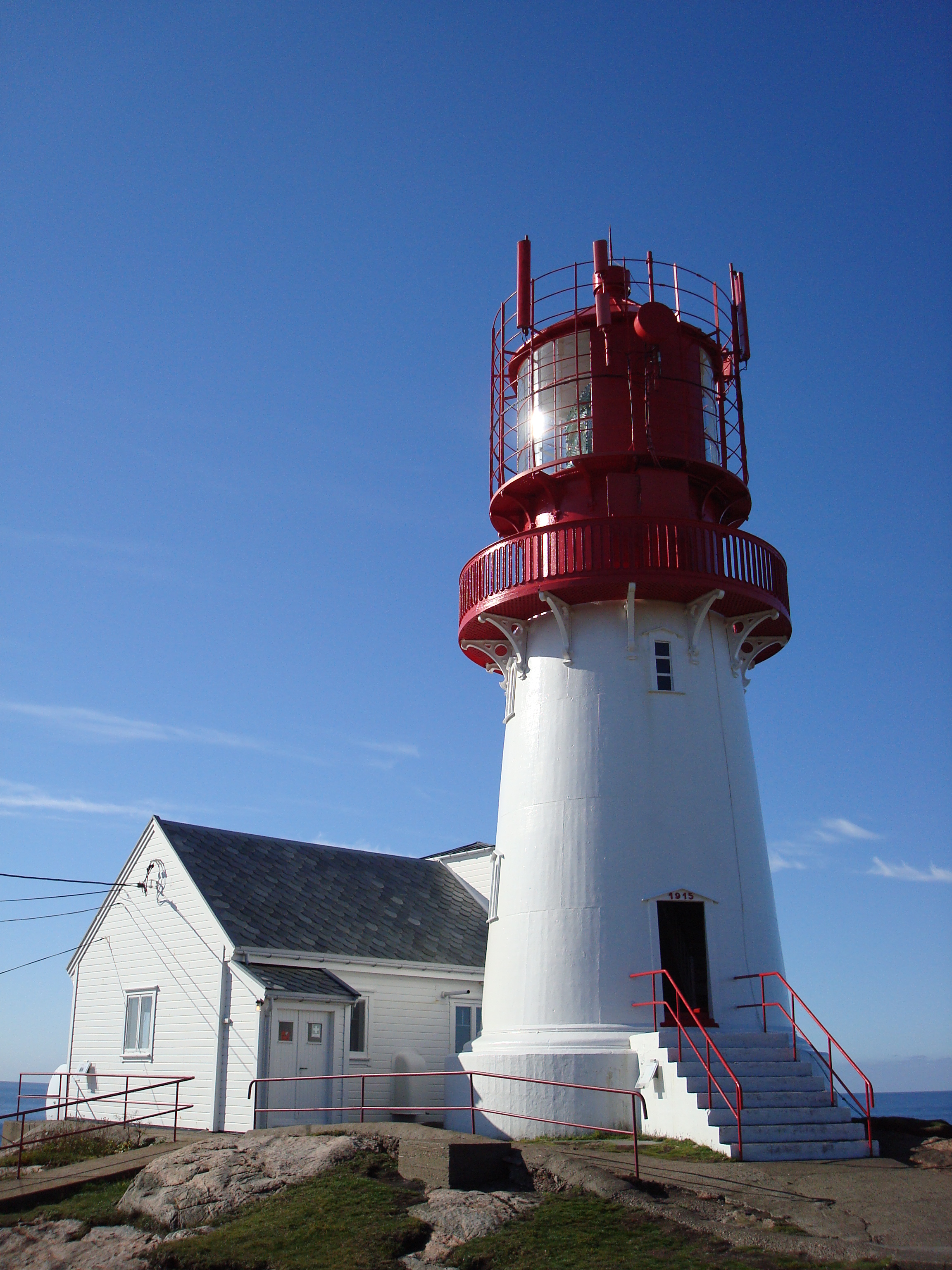
Lindesnes Lighthouse
Every ship sailing between the North Sea and the Baltic must round a particular headland on Norway's southern coast, a wind-battered point where two seas collide. Since 1656, a light has burned at Lindesnes to mark the passage -- making this the oldest lighthouse station in Norway. The current tower, a white cast-iron cylinder with a red cap set on a granite foundation, dates to 1915. But the light itself carries a longer memory, one that stretches back to the age of tallow candles and coal fires, when the alternative to a lighthouse was the rocks beneath the waterline.
Where Two Seas Meet
Lindesnes occupies the southernmost tip of the Norwegian mainland, a geographic fact that gives it significance beyond maritime navigation. To the west lies the North Sea, open and deep. To the east stretches the Skagerrak, the strait connecting to the Baltic. Currents converge here, and the weather shifts without warning -- conditions that made this headland notorious among sailors for centuries. The lighthouse sits at an elevation of 50.1 meters above sea level, and its first-order Fresnel lens throws a white light visible for up to 17.7 nautical miles. The beam alternates between low and high intensity every 20 seconds, a steady pulse against the darkness that has guided countless vessels around the point.
Three and a Half Centuries of Light
The first lighthouse was built here in 1656, making Lindesnes one of the earliest navigational aids in Scandinavian waters. Over the following centuries, the station was rebuilt multiple times as technology evolved. In 1822, the light source was upgraded to a coal lamp. By 1854, a new lamp was installed along with the Fresnel lens that remains in use today -- a piece of 19th-century optical engineering still bending light over the waves more than 170 years later. The current cast-iron tower went up in 1915, fitted with that same veteran lens. Five years later, in 1920, the station received its first fog signal, a siren whose machinery sits in a building beside the tower.
Keeper's Cottages and Mountain Galleries
Lindesnes is still an active lighthouse, owned by the Norwegian Coastal Administration and monitored as part of Norway's navigational infrastructure. But it has also become a museum, operated by the Lindesnes Lighthouse Museum Foundation. The compound includes the original keeper's cottages, sheds, and boathouses -- the domestic architecture of isolation, where families lived for months surrounded by sea and wind. A visitor center has been carved into the mountain behind the station, housing exhibitions, a cinema hall, and a cafeteria. The lighthouse was selected as the millennium site for Vest-Agder county, an acknowledgment that few structures in the region carry as much historical weight. Walking the grounds, you can trace the full arc of Norwegian coastal life: the working machinery of the light, the modest dwellings of those who tended it, and the rocky headland that made all of it necessary.
The Edge of Norway
Standing at Lindesnes, you are as far south as it is possible to go on the Norwegian mainland. The North Cape, at the country's northern tip, lies roughly 2,518 kilometers away as the crow flies. Between those two points stretches one of the longest countries in Europe, a narrow band of mountains, fjords, and coastline. Lindesnes distills that geography into a single vantage point. On clear days, the sea stretches to the horizon in nearly every direction, and the wind carries the salt of two different bodies of water. It is a place that feels like a boundary -- between ocean and strait, between open water and sheltered passage, between the vast maritime world and the land at its edge.
From the Air
Lindesnes Lighthouse is located at 57.98N, 7.05E at the southernmost point of mainland Norway. The white tower with red cap is visible against the rocky headland. Best viewed below 3,000 feet for detail. Kristiansand Airport Kjevik (ENCN) is approximately 70 km to the east-northeast. Lista Airport (ENLI) is closer, roughly 40 km to the west. The headland juts prominently into the sea and is identifiable by the lighthouse compound and visitor center.