Litchfield National Park
About 100 kilometres south-southwest of Darwin, a sandstone plateau called the Tabletop Range breaks the flat savanna and sends water over its edges in waterfalls that run all year. This is Litchfield National Park, where the Top End's wet season — dramatic, torrential, transformative — charges underground springs that keep Florence Falls, Wangi Falls, and Tolmer Falls flowing through the dry months when the rest of the landscape turns brown and dusty. The waterfalls are the reason most people come. They stay for the termite mounds.
The Wagait Country
The Wagait Aboriginal people are the traditional owners of this land, and many still live in the area today. The landscape carries their history in every creek and escarpment. The park was proclaimed a national park in 1986, named after Frederick Henry Litchfield, a Territory pioneer who explored the region in 1864 — walking from Escape Cliffs on Van Diemen Gulf to the Daly River. Before his expedition, before European settlement, this country had supported human life for thousands of years. The ruins of Blyth Homestead, built by pioneers in 1929 and abandoned by the 1960s, are accessible by four-wheel drive and serve as a reminder of how difficult it was to make the land work on European terms.
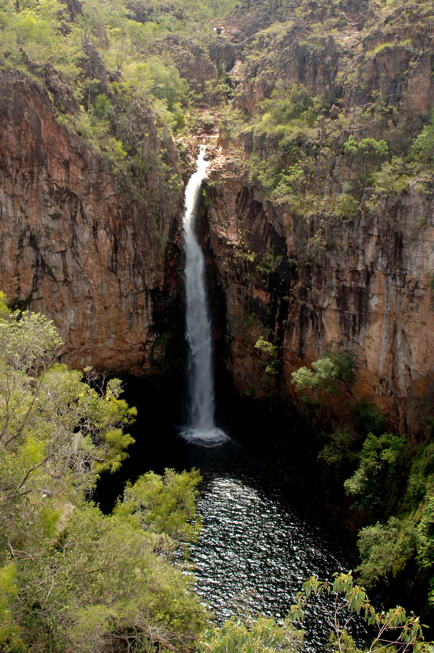
Water Over Stone
Florence Falls is the park's most photogenic moment: a double waterfall dropping through monsoon forest into a pool deep and clear enough to swim in, reached by 160 steps cut into the escarpment. Wangi Falls, the most accessible of the park's swimming spots, runs year-round and has an open picnic area — though heavy wet-season rains can temporarily close the pool. Tolmer Falls is different in character: the plunge pool at its base is home to several colonies of rare ghost bats and orange horseshoe bats, which makes swimming there impossible but watching worthwhile. Buley Rockhole is a series of cascading pools strung together like beads along a creek, just 80 metres from the car park — intimate and easy to reach, popular with families.
For those willing to go further, Tjaynera Falls (Sandy Creek) rewards the effort of a 4WD track and a two-kilometre walk with some of the best swimming in the park.
Sentinels of the Savanna
The magnetic termite mounds are one of Litchfield's stranger sights. These flat, blade-shaped structures, sometimes two metres tall, are oriented almost perfectly north-south — the insects build them this way to regulate internal temperature, minimising exposure to the midday sun. They look like a cemetery of grey tombstones rising from the grass, and the effect is genuinely eerie on a still morning. Elsewhere in the park, the "Lost City" offers sandstone pillars and blocks sculpted by millennia of wind and rain into something that looks, from certain angles, like ruins. It requires a 4WD to reach, and the track is the most challenging in the park — but the formations reward the trip.
The Seasons Shape Everything
The dry season, from May to October, is when most people visit. Days are warm and clear, the waterfalls are accessible, and the 4WD tracks to the more remote attractions are open. During the wet season — December through March — the park transforms. Rain comes in biblical quantities, rivers flood across roads, and access to the southern end of the park closes entirely. What looks like a day trip in July can become impossible in January. The park covers approximately 1,500 square kilometres and is linked at its northern access point to the town of Batchelor via a sealed road — the only paved way in. Two dirt roads serve the southern end: one toward Darwin via Berry Springs, the other toward Daly River.
From the Air
Litchfield National Park is located at approximately 13.05°S, 130.91°E, about 69 km south of Darwin. From the air, the Tabletop Range sandstone plateau is the park's defining feature — a raised, flat-topped escarpment visible against the surrounding savanna. The waterfalls can sometimes be spotted as white lines on the escarpment face in good visibility. Darwin Airport (YPDN) is the nearest major airport. Batchelor Airfield (YBCR) is the closest strip, about 15 km from the park entrance. Best approached from the north in dry season conditions.