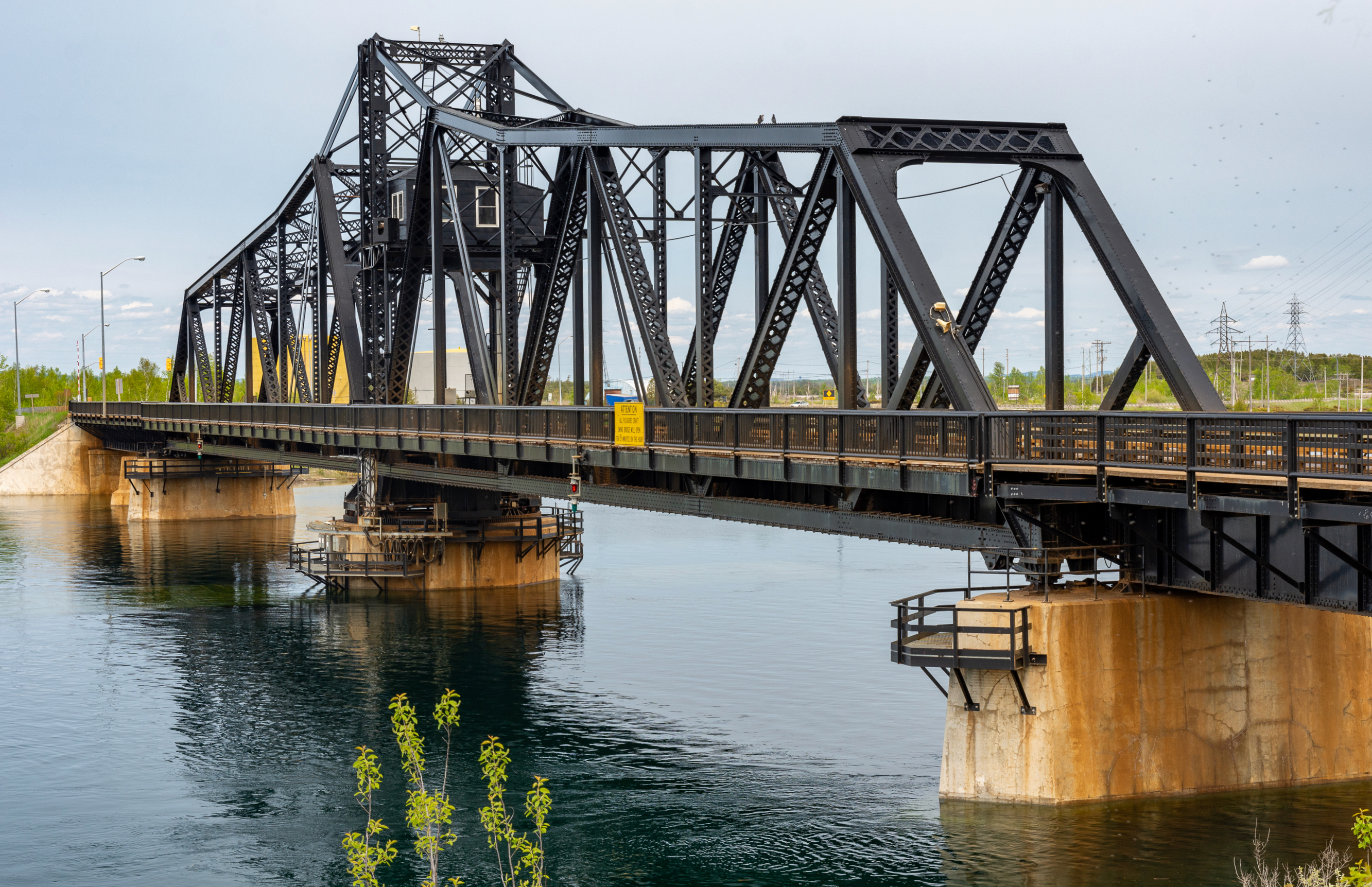
Little Current Swing Bridge
Every hour, on the hour, traffic stops. Cars line up on both sides of the narrow channel between Goat Island and Manitoulin Island, engines idling, while an electric motor groans to life and a 112-meter steel span slowly pivots on its central pier. For fifteen minutes, sailboats and cruisers glide through the 48-meter opening, their masts clearing the gap that connects the North Channel of Lake Huron to the waters beyond. Then the bridge swings shut, the traffic lights cycle, and a single lane of vehicles begins creeping across -- one direction at a time. This is the Little Current Swing Bridge, and for more than a century it has been the bottleneck, the lifeline, and the defining landmark of Ontario's largest freshwater island.
A Railway's Reach to the Island
The bridge exists because of a railroad that no longer does. In 1912, the Algoma Eastern Railway began driving piers into the narrow channel at Little Current, determined to extend its tracks onto Manitoulin Island. The abutments went in that year, and by 1913 the bridge structure was erected and trains were rolling across to the community of Little Current. The Algoma Eastern was a regional line serving the mining and logging industries of northern Ontario, and Manitoulin -- the world's largest freshwater island -- represented both a destination and an opportunity. The bridge they built was a swing type, chosen because the channel carried significant marine traffic and federal navigable waters legislation demanded that vessels have priority passage. The railway's policy reflected this: the swing span stayed open for boats at all times, closing only when a train needed to cross.
From Rails to Roads
In March 1930, the Canadian Pacific Railway leased the Algoma Eastern, and the bridge changed hands. For sixteen years, it remained exclusively a railway crossing. But in 1946, the CPR and Ontario's Department of Highways struck a deal that would reshape the bridge's identity: it was modified to carry road vehicles alongside rail traffic. The operating philosophy flipped. Instead of staying open for boats and closing for trains, the span now stayed closed for road and rail traffic, with a CPR employee stationed at the bridge to open it when a vessel needed to pass. By the 1980s, the CPR had abandoned rail service to Little Current altogether. The tracks ended at a ship-loading facility at Turner, on the Goat Island side, and the bridge passed to Ontario's Ministry of Transportation. The rails were pulled up in the 1990s, and the old railway bed became a quiet reminder of an era when Manitoulin's connection to the mainland ran on steel wheels.
Fifteen Minutes on the Hour
Today, the bridge operates on a schedule that locals know by heart and visitors learn quickly. During spring, summer, and fall, the swing span opens for marine traffic during the first fifteen minutes of each daylight hour. The rest of the time it stays closed for Highway 6 traffic. At night, and throughout the winter when the shipping channel is frozen, the span does not open at all. Originally powered by a gasoline engine, the swing mechanism was upgraded to an electric motor in 2003. Because the bridge carries only a single lane, traffic signals control the flow -- seven lights on the northbound approach, two on the southbound side. These signals hold a distinction of their own: they are the only traffic lights on all of Manitoulin Island.
Manitoulin's Only Lifeline
The bridge's importance magnifies with the seasons. From May through mid-October, the MS Chi-Cheemaun ferry operates between Tobermory on the Bruce Peninsula and South Baymouth on Manitoulin's southern shore, giving the island a second road connection to the mainland. But when the ferry shuts down for winter, the Little Current Swing Bridge becomes the island's sole road link to the outside world. Every grocery delivery, every ambulance call, every resident heading to Sudbury for supplies crosses this single lane of steel and concrete. The bridge was designated an Ontario Heritage site, recognizing not just its engineering but its role in island life. Studies for a replacement structure began in 2018, with the preferred option being a new two-lane bridge -- though any replacement would mean saying goodbye to one of the most distinctive crossings in Canada.
A Bridge Worth Circling
From the air, the swing bridge is unmistakable: a dark steel truss sitting at an angle across the pale blue channel, flanked by the two deck plate girder approaches on the Goat Island side and one on the Manitoulin side. The town of Little Current clusters along the southern shore, its waterfront docks and marinas a reminder that this community grew up around the passage of boats, not cars. The bridge sits just 5.3 meters above the water, low enough that its relationship to the channel feels intimate rather than imposing. Catch it at the top of the hour in summer and you might see the span in motion -- a slow, deliberate rotation that has been part of the rhythm of this place since the days when steam locomotives crossed it on their way to the island.
From the Air
Located at 45.98°N, 81.91°W at the narrows between Goat Island and Manitoulin Island, Ontario. The swing bridge is clearly visible from altitude as a steel truss spanning a narrow channel connecting the North Channel of Lake Huron. The town of Little Current sits on the Manitoulin (south) side. Best viewed from 1,500-3,000 ft AGL to see the bridge structure and its relationship to the channel and surrounding islands. Nearest airports: Manitoulin East Municipal Airport (CYEM) approximately 10nm southeast; Sudbury Airport (CYSB) approximately 55nm northeast. During summer daylight hours, the bridge opens for marine traffic at the top of each hour -- an unusual sight from the air.