Livingstone Falls
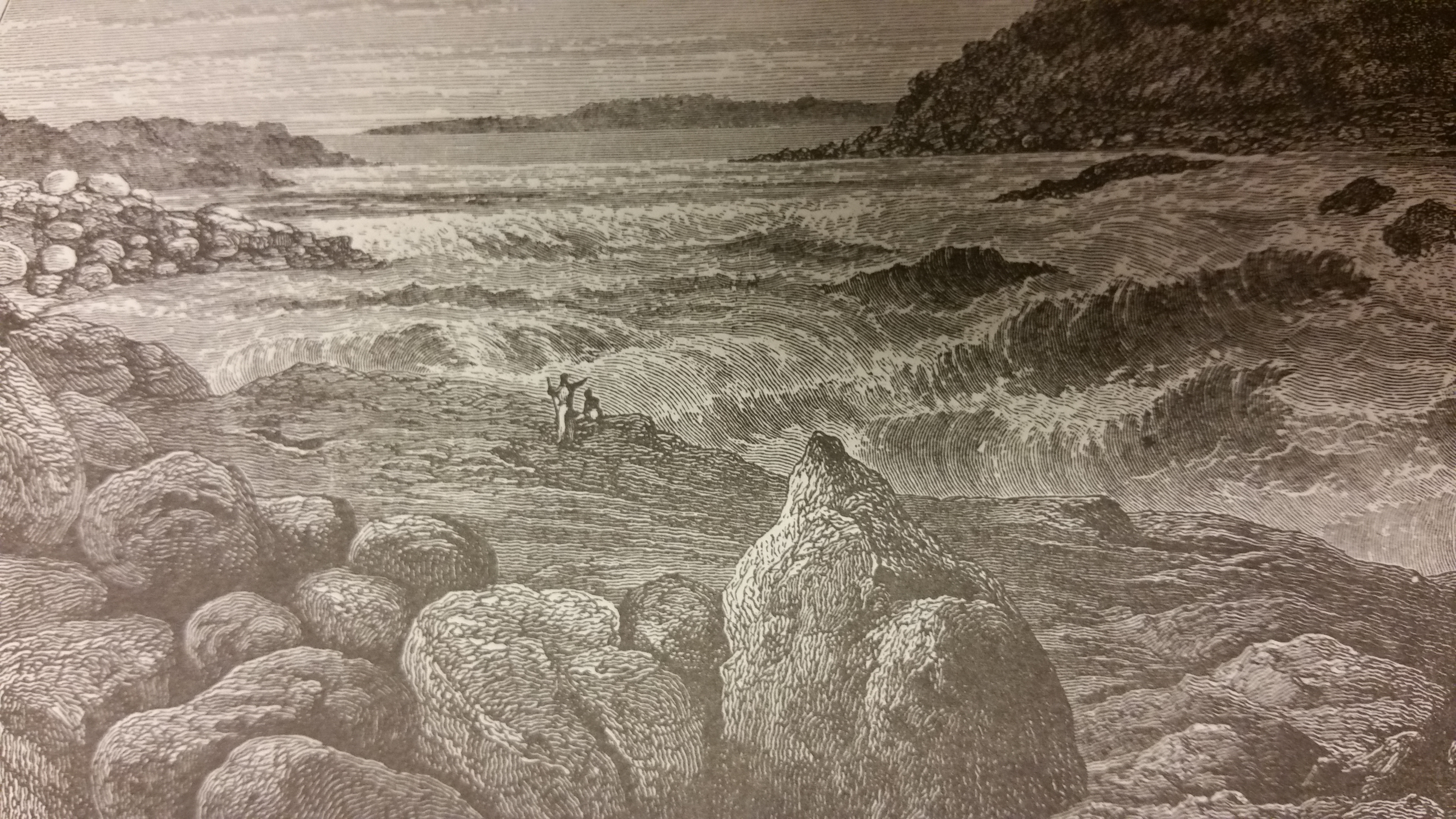
Henry Morton Stanley had seen rivers on four continents by the time he reached the lower Congo in the 1870s. Nothing had prepared him for this. He described it as a strip of hurricane-blown sea, four miles long and half a mile wide, where the river plunged into immense troughs and hurled itself 20 or 30 feet straight upward before crashing down again. The roar, he wrote, was like an express train through a rock tunnel. He named this 220-mile gauntlet of rapids after David Livingstone -- the Scottish explorer who mapped much of the upper Congo but never traveled to this stretch of water. It is one of geography's quiet ironies: the most violent rapids in Africa bear the name of a man who never witnessed them.
The River That Refuses to Be Tamed
Livingstone Falls are not a single waterfall but a succession of rapids dropping 900 feet over 220 miles, beginning downstream of Malebo Pool and ending at the port city of Matadi in Bas-Congo. The Congo River carries the second-largest flow rate of any river on Earth, exceeded only by the Amazon. But the Amazon has no major falls or rapids along its course. The lowest rapids of Livingstone Falls therefore constitute the largest waterfall in the world by volume of water, if one accepts rapids as a form of waterfall. The channel through which this immense volume passes is astonishingly narrow -- less than 300 meters wide in several stretches, and under 800 meters for most of the length. Forcing over 42,000 cubic meters of water per second through such a constriction creates hydraulic forces that are difficult to comprehend.
Two Hundred Meters Down
Scientific investigations in 2008 and 2009 revealed something unexpected: the sections of river between the rapids plunge to depths of up to 200 meters, making portions of the lower Congo among the deepest river channels ever measured. These extreme depths are a direct consequence of the enormous flow rate being squeezed through the narrow gorge. The depths also create isolated environments. The powerful rapids act as barriers separating fish populations from one another, and new species have evolved in close proximity -- a phenomenon that makes the lower Congo one of the most remarkable hotspots of freshwater biodiversity on the planet. Fish pulled from the deep sections have been found with symptoms resembling decompression sickness, their swim bladders distended from the rapid pressure changes.
The Railway Around the Impossible
The rapids made the lower Congo impassable to navigation, cutting off the vast interior of the Congo Basin from the Atlantic coast. This geographical fact shaped the entire colonial and economic history of the region. To bypass the barrier, the Matadi-Kinshasa Railway was constructed, linking the port at Matadi to the navigable waters above the falls at what was then Leopoldville. The railway was built with enormous human cost, but it unlocked the interior for commerce and became the logistical spine of the Belgian Congo. Even today, a weekly passenger train makes the journey from Matadi to Kinshasa in about seven and a half hours, one of the faster rail services in central Africa -- though tickets can only be purchased the day of travel, and getting one is never guaranteed.
Power Beyond Measure
Inga Falls, a group of rapids in the latter portion of the Livingstone Falls system about 177 miles downstream from Malebo Pool, drops 96 meters with a mean annual flow rate of around 42,000 cubic meters per second. The raw power potential is approximately 40 gigawatts. Two large hydroelectric plants already operate at the site. The proposed Grand Inga project would harness this potential on a scale never attempted: a generating capacity of roughly 39 gigawatts, which would make it nearly double the output of China's Three Gorges Dam at 22.5 gigawatts. If completed, Grand Inga would be the largest hydroelectric facility on Earth. The Congo's rapids, which blocked navigation and isolated communities for centuries, may yet become the engine that electrifies a continent.
From the Air
Located at 4.32S, 15.21E on the lower Congo River in the western DRC. The rapids stretch approximately 220 miles from Malebo Pool (near Kinshasa) downstream to Matadi. From altitude, the dramatic narrowing of the Congo River channel is visible, with white water and turbulence evident at lower altitudes. N'Djili International Airport (ICAO: FZAA) in Kinshasa is the nearest major airport. The Inga Dam complex is visible along the river further downstream. Best viewed from 3,000-8,000 feet AGL following the river corridor.