Llullaillaco National Park
In 1999, near the summit of Llullaillaco volcano, archaeologists discovered the frozen bodies of three Inca children sacrificed more than 500 years ago — preserved so perfectly by the cold, dry air at 6,739 meters that they appeared to be sleeping. The mountain that held them is the second-highest active volcano in the world, after Ojos del Salado on the Argentine border, and the national park that surrounds it protects one of the most extreme and least-visited landscapes in all of South America. This is not a place for casual sightseeing. It is a place where the earth pushes toward the sky with such insistence that simply breathing becomes an act of will.
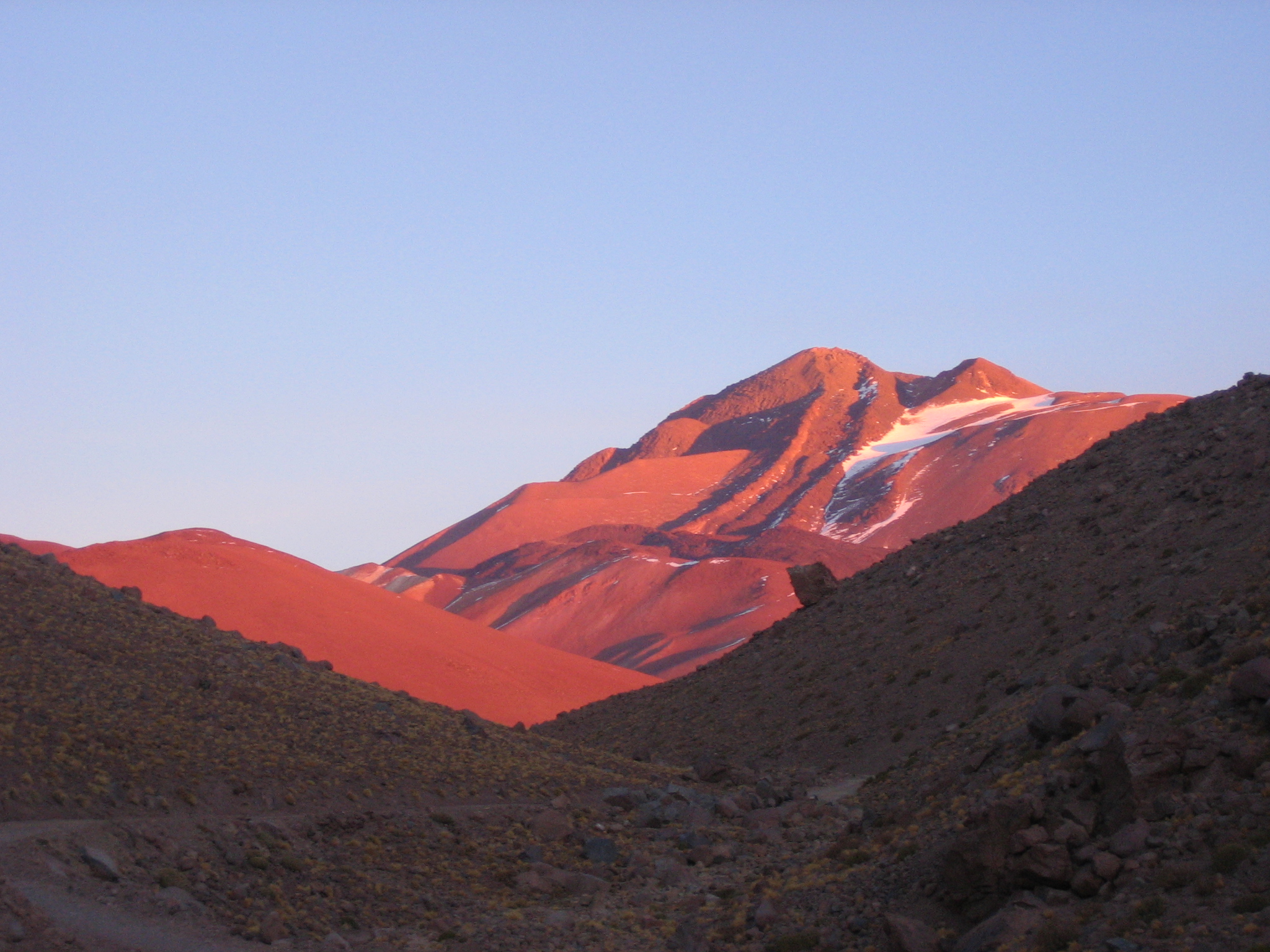
A Landscape Above the Clouds
Even the lowest reaches of Llullaillaco National Park sit at 3,500 meters — roughly the altitude of Lhasa, Tibet. From there, the terrain only climbs. The salt plain of Aguas Calientes stretches across 5,060 meters, a white expanse so high that it approaches the limits of permanent human habitation. Above it all, Llullaillaco itself rises to 6,739 meters, its summit cone visible for vast distances across the Atacama's clear, thin air. Between these extremes, the park holds unexpected variety: vegetated plains at lower altitudes, patches of woodland, and the canyon carved by Rio Frio. Groups of vicunas — wild relatives of the llama, with tawny coats and wary eyes — graze the Pampa Llullaillaco, part of a flora and fauna community with a high percentage of species found nowhere else on Earth.
The Inca Road and Older Ghosts
Five archaeological sites lie within the park's boundaries, including a section of the Inca Trail system that threads through the Rio Frio area. The Inca empire's reach extended this far south, building roads and ritual sites across terrain that challenges modern mountaineers equipped with Gore-Tex and GPS. The children found on Llullaillaco's summit were part of a ceremony called capacocha, in which the Inca offered their most valued sacrifices — children — to the mountain gods. The volcano's extreme altitude and aridity preserved their bodies, clothing, and offerings in extraordinary detail, making them among the best-preserved mummies ever found. Today, these remains are housed in the Museum of High Altitude Archaeology in Salta, Argentina, a reminder that this seemingly empty landscape was once woven into one of the largest empires in the Americas.
Getting There Is the Challenge
Llullaillaco National Park is remote by any standard. The northern entrance requires taking Route B-55 from Antofagasta toward the Socompa border crossing. Pavement ends at the Escondida copper mine, giving way to dirt roads and a 57-kilometer journey to the park gate. The southern approach follows Ruta 5, then branches onto the entirely unpaved B-885 toward Aguas Calientes. No food is available inside the park — everything must be carried in and all waste carried out. A single mountaineering camp provides the only accommodation. For those attempting Llullaillaco itself, a climbing permit and liability disclaimer must be filed with CONAF, Chile's national forestry corporation. The round trip to the summit requires at least a week and a half, including time for the altitude acclimatization that the mountain demands of everyone who approaches it.
Where Altitude Teaches Patience
Altitude sickness is not a risk here — it is a certainty that must be managed. At 3,500 meters, headaches and fatigue announce the thinning air. At 5,060 meters, where the salt plains of Aguas Calientes shimmer in the cold sunlight, the body approaches its physiological limits for sustained habitation. Climbing higher means entering territory where even acclimatized mountaineers move slowly, resting between steps, gauging their bodies for the signs of pulmonary or cerebral edema. The park is open only between September and May, closing for the southern hemisphere winter when conditions become too harsh even by Atacama standards. Mountaineering skills may be required depending on the route, and the park office requires all visitors to sign in at the entrance — a practical measure in a place where help, if needed, is very far away.
The View from Six Thousand Meters
From the air, Llullaillaco National Park presents a study in extremes. The volcano's symmetrical cone dominates the landscape, flanked by the white sweep of the Aguas Calientes salt plain and the brown, treeless expanse of the Pampa Llullaillaco. Rio Frio's canyon cuts a dark line through the plateau. At this latitude and altitude, the sky is a deeper blue than most pilots will see anywhere else on Earth, and the clarity of the air makes distances deceptive — mountains that appear ten kilometers away may be fifty. The park sits close to the Chilean-Argentine border, and on clear days the Andean peaks stretch in every direction, a seemingly endless procession of summits that the Inca once considered sacred and that modern mountaineers still approach with something close to reverence.
From the Air
Llullaillaco National Park is centered at 24.72°S, 68.62°W, with the volcano summit at 6,739 meters (22,110 feet) near the Chilean-Argentine border. The park's terrain ranges from 3,500 meters to the summit. From cruising altitude, Llullaillaco's symmetrical cone is a prominent landmark, with the white Aguas Calientes salt plain visible to its south. The nearest major airport is Cerro Moreno (SCFA) at Antofagasta, roughly 300 km to the northwest. The extreme altitude and dry conditions provide extraordinary visibility but also present density altitude challenges for general aviation. No airports exist near the park.