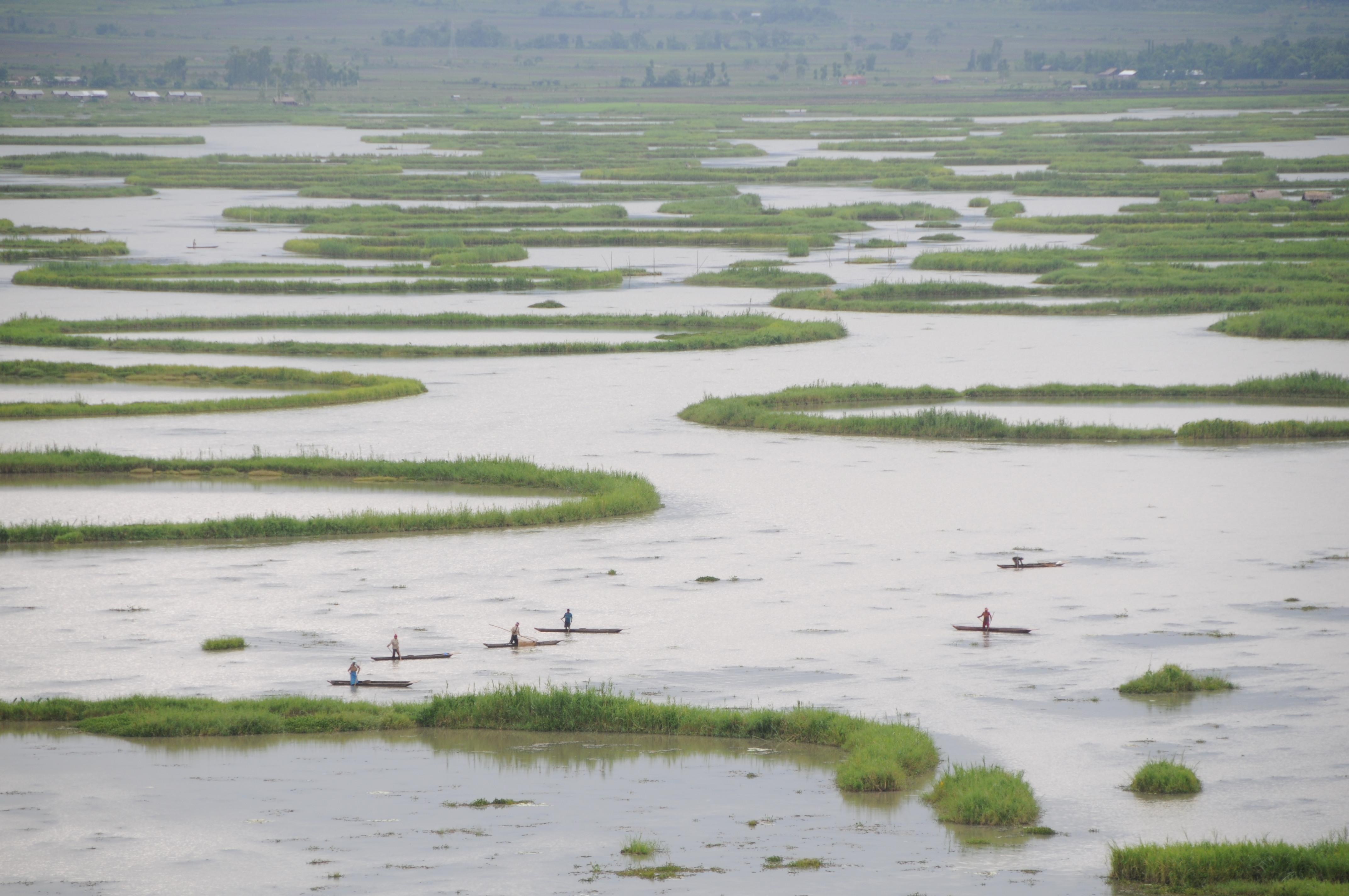
Loktak Lake
From the air, Loktak Lake looks wrong -- as if someone scattered green puzzle pieces across a sheet of water. Those floating patches are phumdis, tangled masses of vegetation, soil, and organic debris that drift across the lake's surface like living rafts. Some are thick enough to support houses. Fishermen have built entire settlements on them, called phumshangs, and the residents harvest fish through holes cut in the vegetative mat beneath their floors. In the Meitei language, "Lok" means stream and "tak" means the end. Loktak is where the streams gather and stop. It is the largest freshwater lake in northeast India, and it breathes -- swelling from 250 square kilometers in the dry season to 500 during monsoon rains.
A Lake That Floats
The phumdis are what make Loktak unlike any other body of water. These heterogeneous masses of vegetation and organic matter form naturally when decaying plant material accumulates and compacts into buoyant mats. Some phumdis are thin seasonal formations; others are dense enough to walk on. The largest concentration covers the southern portion of the lake, where Keibul Lamjao National Park occupies a 40-square-kilometer section -- the only floating national park on Earth. The park exists for a single animal: the sangai, or Manipur brow-antlered deer, a subspecies of Eld's deer once thought to be extinct. Fewer than a hundred survived when the species was rediscovered in the 1950s, living exclusively on the phumdis of Loktak. The deer have adapted to walk on the floating vegetation, their splayed hooves distributing weight across the unstable surface. Their entire world is a mat of decaying plants drifting on a lake in a valley surrounded by hills.
The Economy on the Water
Roughly 100,000 people live in the 55 hamlets ringing the lake and on its floating islands. For the rural fishing communities, Loktak is not scenery -- it is livelihood. The lake yields approximately 1,500 tonnes of fish every year. Fishermen use a traditional technique called athapum: circular phumdis cultivated artificially as fish traps. The state government has introduced millions of fingerlings of Indian and exotic carp species, and nine mini-hatcheries can produce a million fingerlings in a single day. Local fish like ngamu, ukabi, and ngaril -- each known by its Meitei name -- once dominated the catch but are now in serious decline, replaced by introduced species. The lake also feeds the Loktak Hydroelectric Project, generating power through the Ithai Barrage that controls the water level year-round at 786.5 meters above sea level.
Drowning in Slow Motion
The same barrage that generates electricity is strangling the lake. By fixing the water level for power generation, the Ithai Barrage disrupted Loktak's natural pulsation -- the seasonal rise and fall that flushed sediment, renewed nutrients, and allowed phumdis to settle and regenerate. Deforestation and shifting cultivation in the surrounding catchment send an estimated 336,350 tonnes of silt into the lake annually. Sewage from Imphal city flows in through the Nambul River, feeding explosive growth of water hyacinth and accelerating phumdi expansion in places where it chokes navigation. The phumdis in Keibul Lamjao have thinned, threatening the sangai's survival. Fish migration from Myanmar's Chindwin-Irrawaddy river system has been blocked, altering the lake's species composition. The lake that supports 100,000 people and shelters the world's rarest deer is shrinking, silting up, and losing the biological rhythms that kept it alive.
Ramsar, Recognition, and Reality
On 23 March 1990, Loktak was designated a wetland of international importance under the Ramsar Convention, recognizing its extraordinary biodiversity: 233 species of aquatic plants, 425 animal species including Indian pythons, hoolock gibbons, sambar deer, and marbled cats. The designation brought attention but not solutions. The lake's problems are tangled -- 50,400 fishermen encroaching for extensive fishing, undefined ownership split between three districts, and competing demands for hydropower, irrigation, and drinking water. In 2006, the Manipur government created the Loktak Development Authority under a dedicated protection act, but the recommended mitigation measures -- treating urban sewage, reducing sedimentation, resettling phumdi dwellers -- remain largely aspirational.
Islands in the Stream
Within the lake and along its edges, 14 hills rise like anchors, and in the southern waters sit the islands of Sendra, Ithing, and Thanga. The Manipur River feeds Loktak from the north, rising near Karong and flowing south past Imphal before meandering into the lake basin. Every October 15, Loktak Day is observed along the lakeshore -- a reminder that this body of water is not a static feature of geography but a living system on which an entire regional economy depends. From the air during monsoon, the lake dominates the Imphal Valley, a vast mirror reflecting clouds and green islands in equal measure. In the dry months, it contracts, revealing mudflats and the skeletal outlines of phumdis compressed against each other. The lake breathes, but each year the breath comes a little harder.
From the Air
Located at 24.55°N, 93.78°E in the southern Imphal Valley, Manipur. Loktak Lake is an enormous and unmistakable water feature -- the largest freshwater lake in northeast India -- clearly visible from cruising altitude as a dark expanse dotted with green phumdi patches. Nearest airport is Imphal Airport (VEIM/IMF), approximately 30 km to the north. The lake sits at roughly 786 meters elevation. The floating national park (Keibul Lamjao) occupies the southern portion. Best viewed at 8,000-15,000 feet to see the phumdi patterns and surrounding hill ring.