London
Queen Boudicca burned London to the ground in AD 60. The layer of oxidized ash from her rampage is still visible in archaeological excavations - a red-brown stain marking where Rome's British outpost was reduced to cinders. Yet Londinium rose again within years. This pattern would repeat: the Hadrianic Fire around AD 120, the Great Fire of 1666, the Blitz of 1940-41. Each time London burned, each time London rebuilt. The city approaching ten million people today sits on two millennia of destruction and renewal, layer upon layer of ruins beneath the Underground tunnels and Victorian sewers and Roman walls. Something about this bend in the Thames, where the river narrows enough to bridge and deep enough for ships, has refused to let civilization move elsewhere.
The City That Burned
The Great Fire of 1666 started in a baker's shop on Pudding Lane and burned for four days. The conditions were perfect for catastrophe: a months-long drought had left 500,000 inhabitants surrounded by timber-frame buildings sealed with pitch and tar, stables packed with hay, warehouses full of lamp oil and turpentine. When the fire finally died, it had destroyed 80% of the city within the old Roman walls - 13,200 houses, 87 churches, 436 acres of medieval London reduced to smoking rubble.
Remarkably, only six deaths were verified. Most residents simply fled to fields beyond the walls and watched their city burn. What rose from the ashes was different: Christopher Wren rebuilt 51 churches including St. Paul's Cathedral, and new building codes required brick and stone where wood had stood. The medieval city that had grown organically since Roman times was replaced by something planned, something designed to prevent the next fire. It took the Great Fire to make London fireproof.
The Blitz Defiance
On September 7, 1940, German bombers began what would become known as the Blitz - 76 consecutive nights of bombing followed by sporadic attacks until May 1941. Over 43,000 Londoners died. More than 70,000 buildings were destroyed. The intention was to break British morale, to make London ungovernable and force surrender. It failed.
The photograph of St. Paul's Cathedral dome rising above the smoke and flame of December 29, 1940 - what the press called the Second Great Fire of London - became a symbol of defiance. Wren's masterpiece survived, though the buildings around it burned. The Underground stations that served as bomb shelters, the Londoners who emerged each morning from basements to clear rubble and carry on, the absolute refusal to surrender - these became part of how London understood itself. The city had burned before. The city would endure.
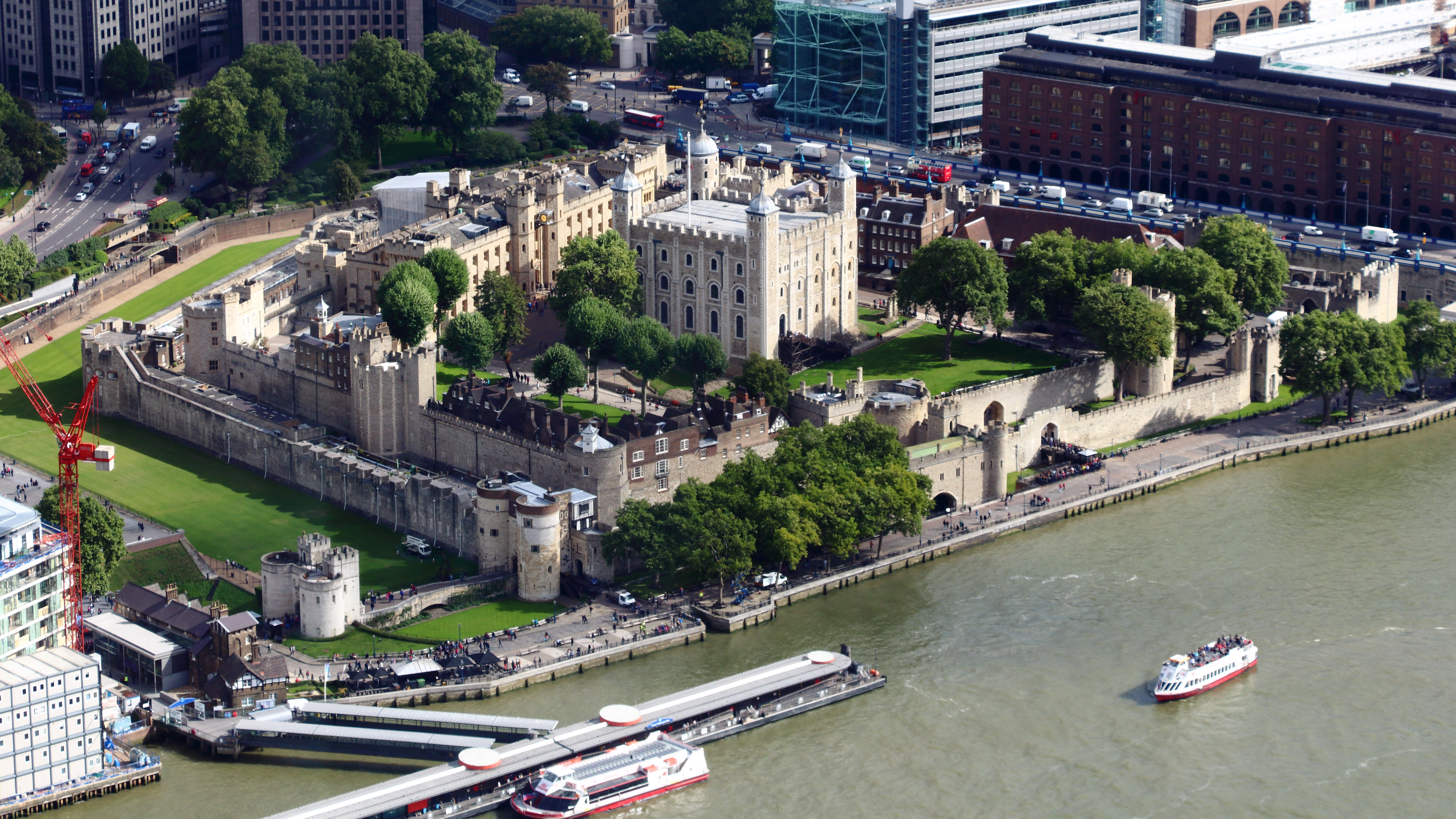
The River That Made Everything
The Thames is why London exists. The Romans recognized what the Celts before them knew: this is where Britain's great river narrows enough to bridge while remaining deep enough for seagoing ships. Londinium was founded at that crossing point in AD 43, and for two thousand years London has been inseparable from its river.
The docks that once made London the world's busiest port are gone now - containerization moved shipping to Tilbury and Felixstowe. But the river remains the spine the city coils around. Westminster and the Houses of Parliament on the north bank. The Tower of London where the river bends east. The bridges that give neighborhoods their character - Westminster Bridge for parliament, Tower Bridge for tourists, Waterloo Bridge for views that never get old. At low tide you can walk the foreshore and find clay pipes from the 1700s, Roman pottery, bones and coins and bottle fragments - the city's discarded history emerging from the mud.
The Underground City
Below London lies another London. The Tube - the world's first underground railway, opened in 1863 - now carries nearly five million passengers daily through 272 stations. But the Underground is only the beginning. Victorian sewers run beneath streets that run above Roman foundations. Disused stations ghost through the network - Aldwych, British Museum, Down Street where Churchill sheltered during the Blitz. Beneath the Bank of England lie gold vaults; beneath Westminster lie tunnels connecting Parliament to the Intelligence services; beneath Whitehall runs a secret bunker that served as government headquarters during World War II.
The layers go down and keep going. A construction project for a new office building might excavate through Victorian basements, Georgian cellars, medieval foundations, and Roman roads before hitting bedrock. London doesn't tear down its past; it builds on top of it. Every step you take walks on centuries.
The City of Villages
Greater London absorbed neighboring towns for centuries until the metropolis sprawled across 607 square miles. But London never became homogeneous. The villages it swallowed kept their names and, to a surprising degree, their characters. Hampstead on its hill feels like a country town that happens to have a Tube station. Brixton pulses with Caribbean influence dating from the Windrush generation. Shoreditch reinvented itself from working-class slum to creative industry hub. Southall's street signs appear in Punjabi.
The city's size means no Londoner knows all of London. A resident of Hackney might cross the river to Peckham once a year; someone in Richmond might visit Stratford only for the Olympics. Each area has its high street, its parks, its feuds with neighboring boroughs, its absolute conviction that it represents the real London. This fragmentation is the city's genius. London works not because ten million people share an identity but because they share a thousand overlapping identities, each rooted in a place that was once its own village and, in some essential way, still is.
From the Air
London (51.51°N, 0.13°W) spreads across the Thames basin in southeastern England, 80km inland from the North Sea. The city covers 1,572 sq km of mostly flat terrain, making the distinctive bend of the Thames and the green spaces - Hyde Park, Regent's Park, the vast Royal Parks - the primary visual references from altitude. Five major airports serve London: Heathrow (EGLL/LHR) 24km west is the UK's busiest with two runways; Gatwick (EGKK/LGW) 45km south; Stansted (EGSS/STN) 50km northeast; Luton (EGGW/LTN) 45km north; and London City (EGLC/LCY) 11km east of central London with a steep 5.5-degree approach over the Docklands. From the air, locate the Houses of Parliament by the Thames bend at Westminster, the Shard's distinctive spike south of the river, the Gherkin and Cheesegrater in the financial district, and the Tower of London where the river curves east. The M25 orbital motorway defines Greater London's approximate boundary. Airspace is extremely complex with multiple controlled zones; expect radar vectors and strict altitude restrictions. Weather is changeable - Atlantic systems bring frequent cloud and rain; fog occasionally closes airports in autumn and winter.