Long Biên Bridge
Half the bridge is original. The other half is improvisation - mismatched steel sections welded and bolted into the gaps where American bombs tore through the spans. Long Bien Bridge crosses the Red River in Hanoi with the visible scars of its history still exposed, rusted iron lattice from 1903 alternating with crude postwar repairs in a kind of architectural confession: this structure has been broken and mended, broken and mended, and it has never stopped carrying traffic. Trains still rumble across it. Mopeds and bicycles thread between the rails. Pedestrians walk the narrow pathways flanked by the bridge's iron ribs, glancing down at the muddy Red River where, below the spans, families from Vietnam's rural provinces live in houseboats.
A Governor-General's Monument
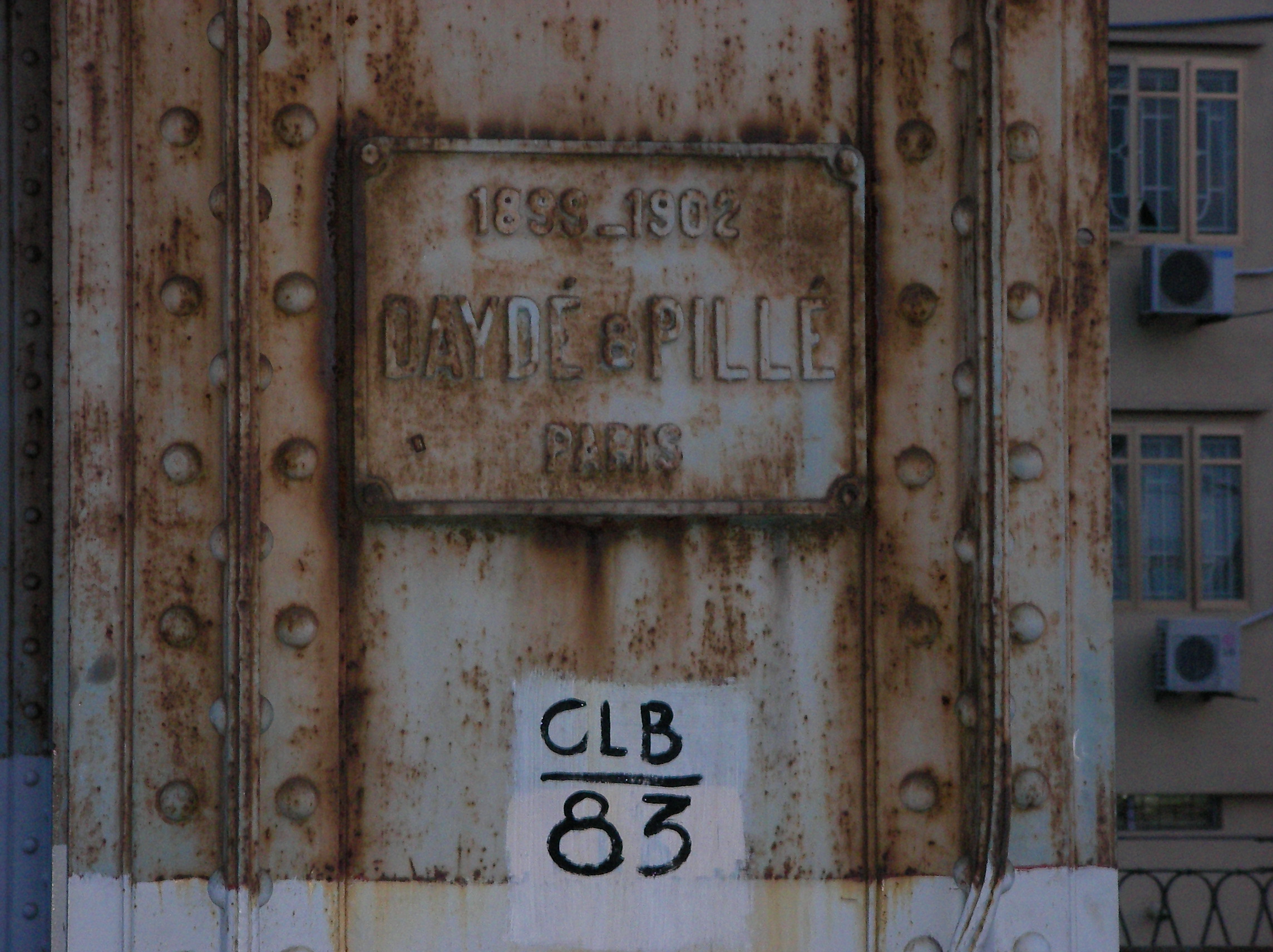
The bridge was built between 1899 and 1902 by Dayde and Pille, a Parisian engineering firm, and opened in 1903. At 2.4 kilometers, it was one of the longest bridges in Asia at the time and a showpiece of French colonial infrastructure in Indochina. Its original name honored Paul Doumer, the governor-general who commissioned it and who later became president of France. The cantilever design was state-of-the-art for the era, its iron trusses spanning the Red River to connect the colonial quarter of Hoan Kiem with the district that would eventually take the bridge's Vietnamese name: Long Bien. For half a century, the bridge served as the primary artery linking Hanoi to the port of Haiphong, carrying the rail traffic that sustained French commercial and military interests in Tonkin.
Target on the Red River
When the Americans began bombing North Vietnam in earnest, Long Bien Bridge became an obvious target - and a frustratingly resilient one. CIA intelligence reports from 1967 noted that severing the bridge caused less disruption than expected; the North Vietnamese simply adapted, rerouting supplies and repairing damage with remarkable speed. Anti-aircraft artillery batteries were mounted directly on the bridge's superstructure to defend it. On May 10, 1972, the bridge took its heaviest blow during the opening strikes of Operation Linebacker, launched in response to the North Vietnamese Easter Offensive. Three days later, the USAF confirmed that laser-guided bombs had destroyed several spans. By August 9, another precision strike disabled the bridge again just as repairs were finishing. On September 11, the Americans hit it a third time. Each time, Vietnamese engineers rebuilt. The bridge became a symbol not of vulnerability but of persistence under bombardment.
The Patchwork That Endures
Walk across Long Bien Bridge today and the history is legible in the steel. Original French ironwork - elegant, riveted, symmetrical - gives way abruptly to cruder replacement sections where bomb damage was patched in the years after 1975. Only about half the bridge retains its original form. The mismatched character has become part of its identity, a physical record of destruction and repair that no restoration could improve upon. A French government-supported project aims to restore the bridge to its original appearance, though progress has been slow. Meanwhile, the bridge carries on in its diminished role. Cars and trucks have long since been diverted to newer crossings - Chuong Duong Bridge, Thang Long Bridge, Vinh Tuy Bridge, Nhat Tan Bridge - leaving Long Bien to trains, two-wheeled vehicles, and foot traffic.
Life Between the Spans
Beneath the bridge, a different Hanoi reveals itself. Families from rural provinces live on houseboats moored along the Red River's banks, occupying the marginal space that the bridge creates between the city's two sides. On the Long Bien side, a sprawling market spills out near the bridge's eastern approach, and the narrow streets of the old district press close to the abutments. The bridge is not a museum piece; it is infrastructure in active, daily use - creaking, vibrating as the trains pass, its metal warming in the tropical heat. For Hanoians, Long Bien Bridge is less a monument than a neighbor, something you cross or pass under or glance at from the riverbank without necessarily thinking about the century of history it carries on its back. That unselfconsciousness may be the truest measure of the bridge's survival.
From the Air
Located at 21.04N, 105.86E, crossing the Red River in central Hanoi. The 2.4 km cantilever bridge is a prominent visual landmark from the air, easily identifiable by its distinctive iron truss structure spanning the wide, brown Red River. Nearest airport is Noi Bai International (VVNB), approximately 20 km northwest. Several newer bridges cross the Red River nearby - Chuong Duong Bridge runs parallel just to the south. The bridge connects the Hoan Kiem District on the west bank to Long Bien District on the east. Best viewed at lower altitudes where the contrast between original and repaired sections is visible.