Longju
In 1959, Indian Prime Minister Nehru told parliament that Longju was a five-day march from Limeking, which itself was a twelve-day march from the nearest road at Daporijo. Three weeks of dense forest, indigenous ladder-climbs, and rope bridges separated this tiny settlement from anything resembling a government office. Yet it was here, in a place most officials had never visited, that a line drawn in a conference room in 1914 collided with the reality of mountains, rivers, and the people who actually lived among them. The Longju incident of August 1959 killed at least one Indian soldier, took others prisoner, and marked what scholars have called the transition in China-India relations from verbal to physical violence.
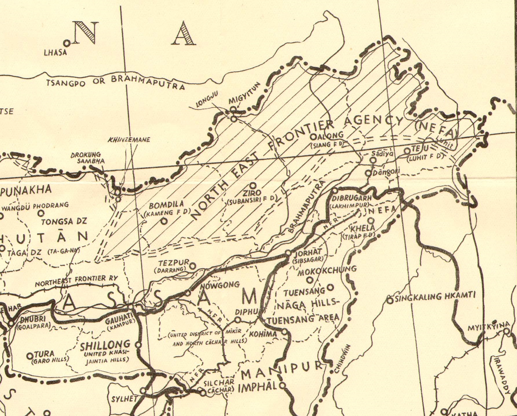
The Line That Nobody Walked
During the 1914 Simla Conference, British negotiator Henry McMahon drew the boundary between India and Tibet along the high Himalayan ridgeline. In most places, the McMahon Line followed natural watershed features. But near Longju, complications arose. The Tibetan frontier town of Migyitun sat just to the north, and the sacred mountain Dakpa Sheri lay nearby, with an annual Tibetan pilgrimage route circling it. McMahon promised to accommodate both, drawing the line along a rough diagonal that avoided the main ridges. The result was a boundary that left Longju in an ambiguous position. The US Office of the Geographer's database places the treaty line with Longju on the Tibetan side. But when the Surveyor General of India revised maps in the 1930s using better topographical data, the boundary shifted southward near Migyitun, putting Longju within Indian territory. Two different versions of the same border, both claiming legitimacy.
Three Weeks from the Nearest Road
The Mara clan of the Tagin tribe had populated this area long before any government claimed it. When British explorers Bailey and Morshead visited in 1905, they found the river crossing near Longju broken. The bridge had been built with tribal materials and techniques that the Tibetans could not replicate. Tibetan authority effectively stopped at Migyitun. The area's remoteness was not just a geographic fact but a political one: for decades, the McMahon Line remained unimplemented because neither side could effectively administer the territory it claimed. It was not until the 1930s, when Deputy Foreign Secretary Olaf Caroe revived the McMahon Line and published it in revised treaties, that the boundary began to appear on official maps as the limit of Assam.
August 1959
The trigger was the 1959 Tibetan uprising. As Chinese troops moved to suppress the revolt, the PLA deployed along the McMahon Line, with four regiments in the Shannan region bordering Subansiri and Kameng Divisions. India responded by establishing advance posts manned by the Assam Rifles. On 25 August, a Chinese force of two to three hundred men surrounded an Indian forward picket of twelve personnel near Longju and opened fire, killing one soldier and wounding another. The survivors were taken prisoner, though some escaped. The next day, the Longju post itself was attacked with overwhelming force, and the entire contingent withdrew south to Daporijo. Chinese troops entrenched themselves at the Indian post, digging mines and building fortifications. When India protested, China claimed the Indian troops had fired first and withdrawn of their own accord. Zhou Enlai used the occasion to assert that existing maps were "substantially correct," a statement that effectively laid claim to all of Arunachal Pradesh.
A Superpower Asks Why
On 2 October 1959, barely a month after the incident, Soviet leader Nikita Khrushchev confronted Mao Zedong directly: "Why did you have to kill people on the border with India?" Mao replied that India had attacked first. Zhou Enlai, present at the meeting, challenged Khrushchev: "What data do you trust more, Indian or ours?" Khrushchev's response was blunt: there were no deaths among the Chinese, only among the Indians. Nehru and Zhou exchanged proposals for maintaining the status quo. India withdrew from Tamaden, another contested post, and invited China to reciprocate at Longju. Chinese forces withdrew from the Indian post but remained in strength at Migyitun. The Assam Rifles set up a new post at the village of Maja, three miles south of Longju. The incident resolved nothing. Instead, it established the pattern of claim and counterclaim, advance and withdrawal, that would define the Sino-Indian border for decades to come and culminate in the 1962 war three years later.
From the Air
Located at 28.64N, 93.38E in the Tsari Chu river valley along the disputed India-China border in Arunachal Pradesh / Shannan Prefecture, Tibet. Extremely remote and mountainous terrain with dense forest cover. The valley runs roughly north-south between high Himalayan ridges. No nearby commercial airports; the nearest airfield is at Along (Arunachal Pradesh). From altitude, the area appears as unbroken forest canopy broken by river valleys. Expect severe turbulence and rapidly changing weather conditions in this eastern Himalayan region.