Los Angeles Basin
Before Los Angeles was a city, before it was a mission, before it was inhabited by anyone, the land that would become one of the world's great metropolises was at the bottom of the ocean. The Los Angeles Basin is a sedimentary depression — a geologically young, tectonically active structure formed where the Pacific Plate meets the North American Plate. Everything that has been built on top of it sits on ground that is still, slowly, in motion.
How the Basin Formed
The Los Angeles Basin formed in a submarine environment — underwater, under pressure, accumulating sediment over millions of years as the Pacific Plate rotated and compressed against the continent. The result is a bowl-shaped depression of deep sedimentary rock, rimmed by the Transverse Ranges to the north (the San Gabriel and Santa Monica Mountains), the Peninsular Ranges to the east and south (the San Jacinto and Santa Ana Mountains), and open to the Pacific to the southwest.
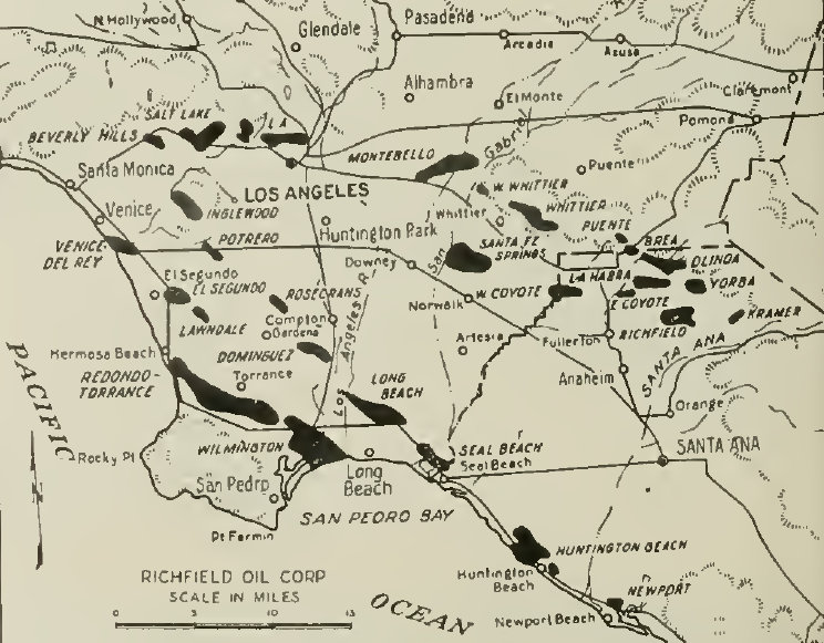
The sedimentary layers that fill the basin are thick — in some places several miles deep — and they contain the oil and gas deposits that made Southern California attractive to the petroleum industry in the late nineteenth and early twentieth centuries. The Inglewood, Wilmington, Long Beach, and Signal Hill oil fields all draw from these same subsurface formations.
The Fault Systems
The basin is not simply a passive container. It is criss-crossed by fault systems that reflect the ongoing collision of tectonic plates. The Newport-Inglewood Fault runs diagonally across the basin from northwest to southeast, passing beneath the oil fields of the Baldwin Hills and continuing offshore. It was the source of the 1933 Long Beach earthquake, which killed 115 people and triggered the creation of California's Field Act — the first law in the country requiring earthquake-resistant construction in schools.
The Whittier Fault runs along the basin's eastern edge. The Palos Verdes Fault lies offshore to the southwest. The Puente Hills Fault runs beneath the basin's eastern portion and, according to seismologists, poses a serious threat to downtown Los Angeles because a rupture there could generate strong shaking across the most densely developed part of the region.
The San Andreas Fault — the primary boundary between the two plates — runs north of the basin through the San Gabriel Mountains, but it influences the stress field across the entire region.
A Basin That Breathes
The basin is a ground-level inversion trap. Mountains on three sides and the cooling marine layer from the Pacific create weather patterns that historically concentrated air pollution in the basin floor, particularly during summer months when temperature inversions trap exhaust and industrial emissions beneath a warm air layer. The smog that defined Los Angeles's reputation in the mid-twentieth century was not an accident of moral failure but a structural consequence of the basin's topography.
The same topography that traps pollution also creates the mild temperatures that have drawn population for over a century. The mountains block cold continental air masses, the ocean moderates summer heat, and the basin floor stays warmer in winter than comparable latitudes inland. The climate is, structurally, a product of the bowl.
The Ground Beneath the City
More than 13 million people live in the greater Los Angeles Basin today. The infrastructure they depend on — water systems, pipelines, highways, rail lines — rests on a geological structure that planners and engineers must account for in everything they build.
Liquefaction, the process by which saturated sedimentary soils lose cohesion during an earthquake and temporarily behave like liquid, is a significant hazard in low-lying parts of the basin near rivers and the coast. Subsidence — the gradual sinking of the ground surface — has been documented in areas where groundwater has been extracted, and where oil and gas production has occurred.
The Los Angeles Basin is, from one perspective, one of the great engineering challenges in human history: a seismically active, geologically complex structure holding one of the largest urban populations on the planet. From another perspective, it is simply home.
From the Air
The Los Angeles Basin is best understood from altitude — a roughly triangular lowland clearly framed by mountain ranges. The San Gabriel Mountains form the northern wall, the Santa Monica Mountains close the northwest corner, and the lower Puente and Santa Ana hills bound the south and east. The basin floor is entirely covered by urban development, with the Los Angeles River drainage visible as a concrete channel running through the eastern and southern portions.