Los Estoraques Unique Natural Area
Colombia calls it an Area Natural Unica -- a Unique Natural Area -- and the designation is not bureaucratic modesty. Los Estoraques defies the templates that national parks usually follow. There are no glacial lakes, no volcanic peaks, no towering canopy forests. Instead, on six square kilometers of dry hillside in the Cordillera Oriental, sandstone has been carved by wind and water into formations that look like nothing so much as a ruined city built by giants. Columns rise 30 meters from the canyon floor. Pedestals balance improbable boulders on narrow stems. Cones and caves punctuate a landscape that has been four million years in the making, and the only trail through it takes barely two hours to walk.
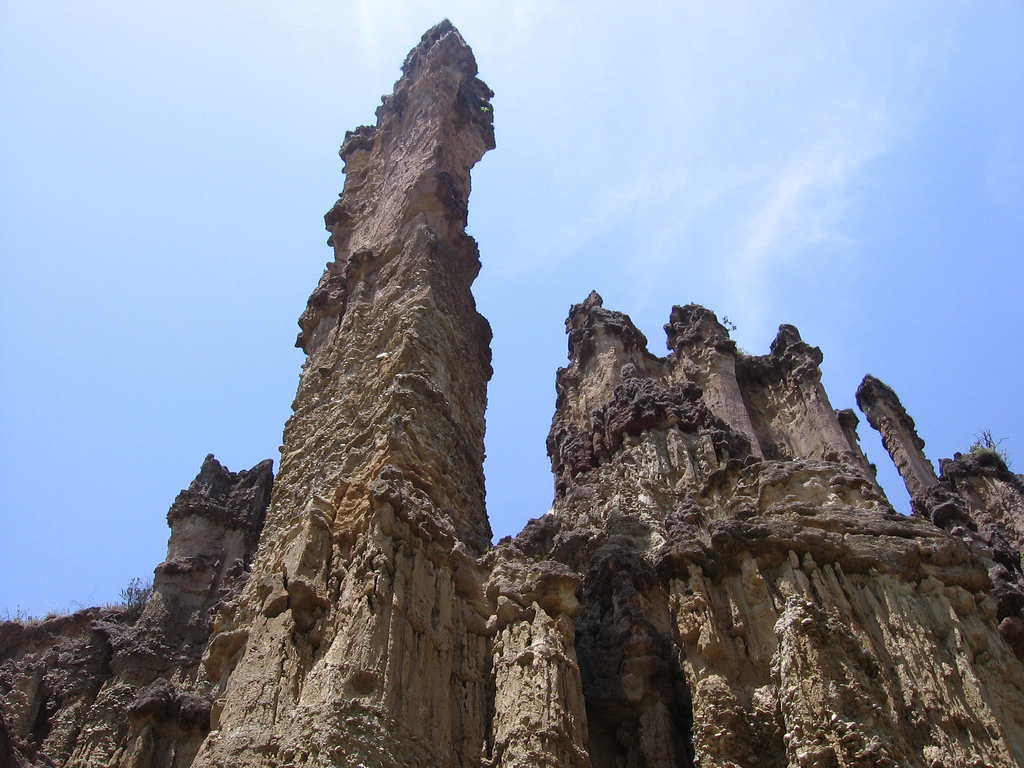
A Stone Forest in the Dry Hills
The formations that give Los Estoraques its name are brownstone pedestals and columns shaped by erosion over millennia. The process is straightforward -- wind, rain, and the relentless cycle of wet and dry seasons have carved softer sedimentary layers from beneath harder capstones, leaving pillars that taper toward their bases like sandcastles built upside down. The results, however, are anything but ordinary. Visitors walking the park's single three-kilometer trail pass through narrow canyons where the walls close overhead, past towers that cast long shadows across the ravine floor, and up to viewpoints where the full scale of the erosion becomes clear. The landscape has been compared to a stone forest, and the comparison holds: there is the same sense of walking through something ancient and vertical, something that belongs to a different geological vocabulary than the green Andean slopes surrounding it.
Where Dry Forest Meets Cloud
Los Estoraques sits at an elevation between 1,450 and 1,900 meters, straddling two distinct ecosystems. The lower sections support dry tropical forest, where species like Dodonaea viscosa and wild guava cling to rocky soil that receives only 870 millimeters of annual rainfall -- roughly half of what most tropical landscapes need. Evapotranspiration here runs double the precipitation rate, creating a persistent water deficit that shapes everything from root structure to animal behavior. Climb higher, and the landscape shifts. Sub-Andean cloud forest wraps the upper slopes in fog for much of the year, sheltering Andean oak and horse-chestnut trees beneath a canopy that traps moisture from the clouds. The transition between these two worlds happens over just a few hundred meters of elevation -- a compressed gradient that makes the park's six square kilometers remarkably biodiverse for their size.
Creatures of the Canyon
The park's wildlife reflects its transitional position between dry lowlands and cloud forest. Jaguarundis -- small, sleek wild cats with unmarked coats -- patrol the rocky terrain alongside crab-eating foxes, opportunistic canids that hunt invertebrates and small mammals along stream courses. Tapetis, the forest rabbits of the neotropics, shelter in the undergrowth. Common opossums forage through both forest types after dark. Overhead, more than 50 bird species have been recorded, including the laughing falcon, whose distinctive call -- a rising series of notes that ends in what sounds like laughter -- carries across the canyon walls. The park's small size makes it vulnerable: six square kilometers offers limited territory for predators and limited genetic diversity for all species. But its protected status, maintained since 1988 under Colombia's National Natural Parks system, has kept the habitat intact.
La Playa de Belen and the Edge of Discovery
The gateway to Los Estoraques is La Playa de Belen, a colonial village of fewer than 2,000 inhabitants that sits just outside the park boundary. Whitewashed houses with clay-tile roofs line cobblestone streets decorated with flower-filled balconies -- architecture so well preserved that the town has been designated one of Colombia's Pueblos Patrimonio. It is a village that feels centuries removed from the nearest city, and in practical terms it nearly is: reaching La Playa de Belen requires hours of driving on winding mountain roads through Norte de Santander. This remoteness is both the park's challenge and its gift. Los Estoraques receives a fraction of the visitors that flock to Colombia's better-known parks, leaving its trails quiet and its formations undisturbed. The dry season from January through March offers the best conditions for hiking, when the sandstone glows warm in the sun and the canyons are passable without mud. For those who make the journey, the reward is a landscape that exists nowhere else in Colombia -- and a reminder that six square kilometers can hold four million years of wonder.
From the Air
Located at 8.23N, 73.18W in the Cordillera Oriental of Colombia's Norte de Santander Department. The park sits between 1,450 and 1,900 meters elevation in a dry mountain valley within the Catatumbo River basin. The nearest significant airport is Camilo Daza International Airport (SKCC) in Cucuta, roughly 120 km to the northeast. The sandstone formations are small-scale and not individually visible from altitude, but the dry, pale terrain contrasts with the surrounding green mountain slopes. The colonial town of La Playa de Belen is visible adjacent to the park. Best appreciated at 5,000-8,000 feet AGL for terrain context. The area is characterized by winding mountain roads and limited infrastructure.