Los Katíos National Park
A tree called the cativo grows in the floodplains of northwestern Colombia. It can reach fifty meters -- taller than a twelve-story building -- and it forms dense, cathedral-like stands known as cativales that exist nowhere else on Earth except Colombia, southern Central America, and Jamaica. These trees anchor one of the most biologically significant landscapes in the Western Hemisphere: Los Katíos National Park, 72,000 hectares of mountains, swamps, and river plains wedged between the Darién wilderness of Panama and the mighty Atrato River of Colombia.
Where Two Continents Collide
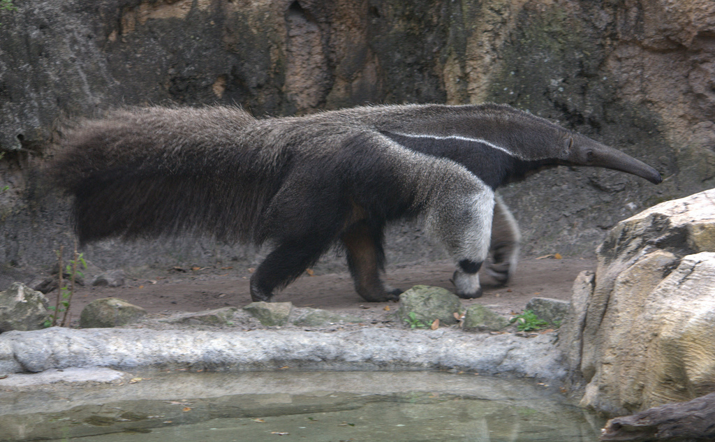
Los Katíos sits on the isthmus that stitches North and South America together, and that position makes it a biological crossroads unlike anywhere else. Species that evolved on separate continents for millions of years meet here. The Central American tapir and the giant anteater, the spectacled caiman and the American manatee -- animals whose ranges barely overlap elsewhere -- share this narrow strip of land. Around 450 bird species have been recorded within the park, representing roughly a quarter of Colombia's total avifauna and half of Panama's. The Atrato River basin, which the park drains into, harbors 116 freshwater fish species, the highest richness of any river system in the Chocó-Darién ecoregion. It is the only place in South America where a large number of Central American species occur, a fact that earned it UNESCO World Heritage status in 1994.
Mountains, Marshes, and Falling Water
The park's terrain divides roughly into two zones. To the west, the Serranía del Darién mountains rise through low hills of 250 meters to ridgelines above 600 meters, their slopes covered in dense tropical forest. To the east, the Atrato River floodplains spread across the lowlands in two distinct layers: low terraces that flood regularly with each rainy season, and higher terraces that stay dry most of the year. Swampy marshes cover nearly half the park's total area. Two waterfalls punctuate this landscape with particular drama. The Tendal waterfall drops 25 meters through the forest in a single curtain of white water, while the Tilupo waterfall plunges 100 meters down a cliff face surrounded by mist and ferns. The Ciénagas de Tumaradó, a complex of swamp lakes fed by the Atrato's overflow, shelter manatees and caimans in waters stained dark by tannins leaching from the forest floor.
A Park in Peril and Recovery
In 2009, the Colombian government took the unusual step of asking UNESCO to place Los Katíos on the List of World Heritage in Danger. Illegal logging was stripping the cativales. Unauthorized settlements had pushed into the park's buffer zones. Overfishing was depleting the Atrato's once-abundant stocks, and armed groups operating in the region made enforcement nearly impossible. For six years the park carried the danger designation, a formal acknowledgment that one of the world's most important natural areas was slipping away. Then, gradually, conditions improved. Colombian authorities cracked down on timber extraction and illegal fishing. Park management was restructured and better funded. By 2015, UNESCO's World Heritage Committee voted to remove Los Katíos from the danger list, recognizing the significant progress Colombia had made. The park is not out of the woods -- the Darién remains a corridor for migration, smuggling, and territorial disputes -- but the cativales still stand, the manatees still surface in the Tumaradó swamps, and the giant anteaters still patrol the forest floor.
The Road That Never Came
Los Katíos shares its western boundary with Panama's Darién National Park, and together the two reserves form a contiguous wilderness spanning the border. This is where the Pan-American Highway would pass if it were ever completed as originally proposed. The road's absence has preserved the park's isolation, but that isolation cuts both ways. It protects biodiversity from the encroachment that highways inevitably bring, yet it also limits the park's accessibility to researchers, tourists, and the rangers tasked with protecting it. Reaching Los Katíos typically means traveling by boat up the Atrato or hiking in from small towns on the park's periphery. The journey itself is part of the experience: hours on the river watching kingfishers and herons work the banks, the forest canopy closing overhead until the world narrows to water, green, and sky.
From the Air
Located at 7.80°N, 77.15°W in the Chocó and Antioquia departments of northwestern Colombia, adjacent to Panama's Darién National Park along the border. From the air, the park is distinguished by the contrast between the dark green mountain forests of the Serranía del Darién to the west and the silvery, flooded plains of the Atrato River to the east. The Ciénagas de Tumaradó swamp lakes are visible as dark patches within the floodplain. Nearest airport: Turbo (SKTU) to the northeast. Best viewed at 5,000-8,000 ft altitude. The park is part of the Darién Gap, visible as the great break in cleared land where Panama and Colombia meet.