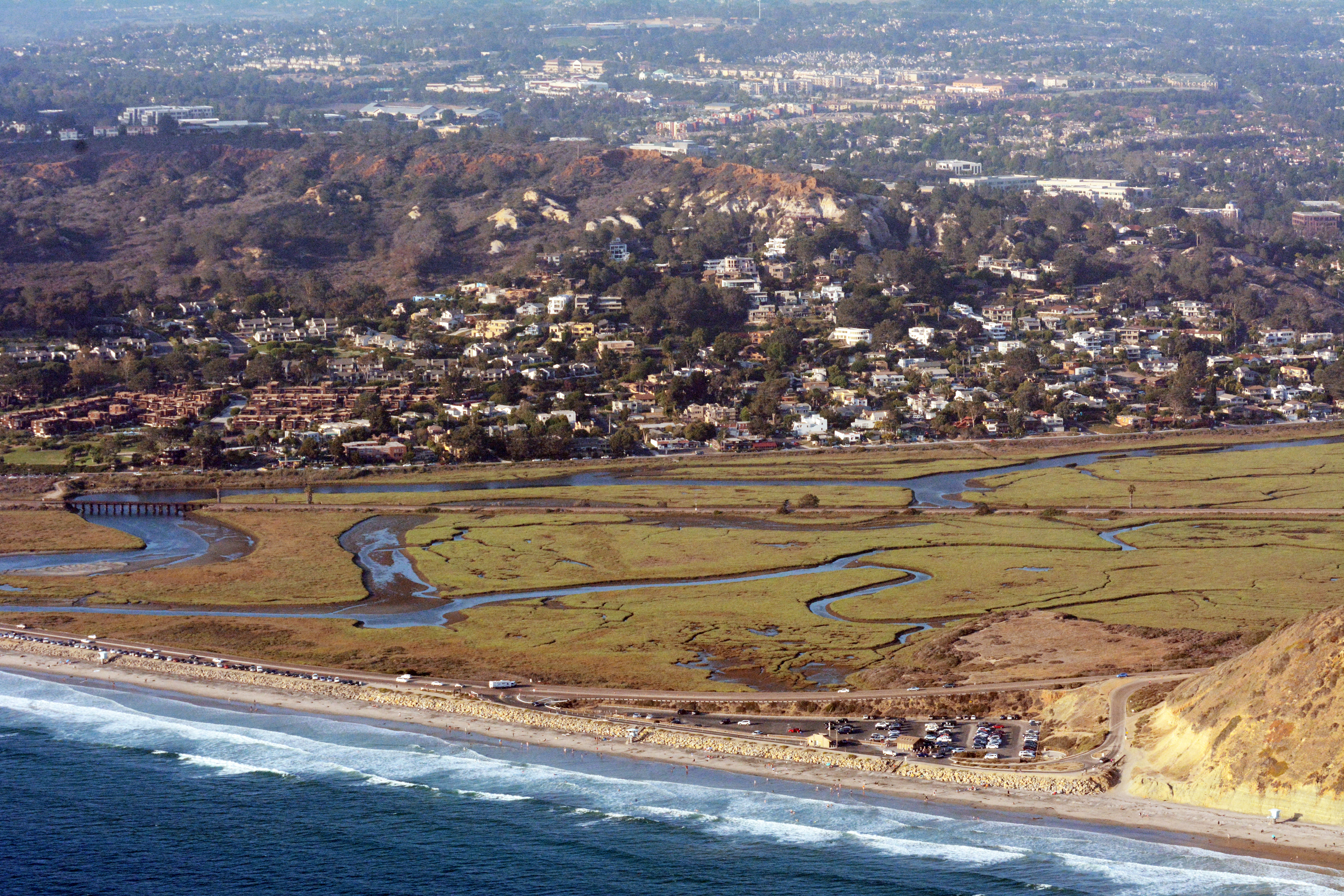
Los Peñasquitos Lagoon
The name means 'the little cliffs,' a reference to the sandstone bluffs that frame the lagoon where the Peñasquitos Creek meets the Pacific. Los Peñasquitos Lagoon covers 500 acres of coastal marsh between Del Mar and Torrey Pines, and its history begins approximately 6,000 to 5,000 years ago, when Kumeyaay people established a shellfish-harvesting economy along its shores. What those people built over the following millennia — a sophisticated relationship with one of the most productive ecosystems on the California coast — is now maintained by biologists conducting managed breaches of the lagoon mouth, a modern form of the same ecological attention that sustained the lagoon for thousands of years before European settlement changed everything.
Six Thousand Years of Human Presence
The Kumeyaay village of Ystagua stood near the lagoon from approximately 1,300 years ago until the Spanish mission period disrupted the region's indigenous settlement patterns. But evidence of Kumeyaay use of the lagoon and its resources goes back much further — the shellfish middens along the shore date to 6,000 or 5,000 years before the present, suggesting a continuous human relationship with this ecosystem spanning most of recorded history.
The lagoon was productive because it is an estuary — a place where freshwater from Peñasquitos Creek mixes with ocean saltwater, creating conditions of intermediate salinity that support high concentrations of invertebrates, fish, and the birds that feed on them. Coastal marshes like Los Peñasquitos are among the most biologically productive ecosystems on earth, and the Kumeyaay, who understood the seasonal rhythms of the lagoon's productivity across generations, used it accordingly.
The first Mexican land grant within what is now San Diego County was issued in 1823 for the land surrounding this lagoon — the Rancho Santa María de los Peñasquitos, granted to Francisco María Ruiz. The grant acknowledged the lagoon's centrality to the local landscape, and the name it attached to the place has persisted through every subsequent change in ownership and political jurisdiction.
Three Corridors Across the Marsh
By the twentieth century, three major transportation corridors had crossed Los Peñasquitos Lagoon in rapid succession. The Pacific Coast Highway (now Coast Boulevard/U.S. 101) crossed in 1891. The Santa Fe Railroad's Surf Line had already cut across the lagoon in 1887. Interstate 5 was built through it in 1965. Each crossing constricted the tidal flow that feeds the lagoon's ecology, reducing the exchange of ocean water that maintains salinity gradients and flushes accumulated sediment.
This pattern — coastal wetlands severed and restricted by infrastructure built with no consideration for ecological function — played out across California throughout the nineteenth and twentieth centuries. Los Peñasquitos Lagoon survived as a functioning estuary where many others did not, partly because it was given California State Preserve status, which imposed legal protections on further development, and partly because advocates recognized what was at stake early enough to prevent the most damaging interventions.
The consequences of restricted circulation are real and ongoing. The lagoon now functions as a breeding ground for West Nile virus-carrying mosquitoes in ways that a more freely circulating estuary would not. Sediment accumulates in the tidal channels. The mouth of the lagoon tends to close as sand deposition exceeds tidal scouring, cutting off the ocean exchange that the entire ecosystem depends on.
Managing What Remains
The managed breach has become the primary tool for maintaining the lagoon's ecological function. One to three times per year, managers mechanically open the lagoon mouth when it has closed or restricted enough to threaten water quality and habitat. The controlled opening allows tidal exchange to resume, salinity to normalize, and the biological community to persist.
This is not a perfect solution — it is a substitute for the natural tidal dynamics that the infrastructure corridors disrupted. But it is an honest acknowledgment that the lagoon cannot maintain itself in its current constrained condition without human intervention, and that the intervention is worth doing. The three hundred plant species and three hundred bird species that use the lagoon — representing roughly forty percent of all North American bird species ever recorded — depend on the estuary functioning well enough to support the food web that sustains them.
Los Peñasquitos Lagoon is what remains when a coastal wetland survives the development pressure of a major metropolitan area. It is smaller than it was, more constrained, more carefully managed, and more fragile than it would have been without three transportation corridors crossing its waters. But it is still there — the little cliffs still frame it, the tides still move through it, and the birds still come, as they have for six thousand years.
From the Air
Los Peñasquitos Lagoon sits at 32.93°N, 117.25°W at the coast between Del Mar and Torrey Pines State Reserve. From altitude heading south along the coast, the lagoon is visible as a distinct wetland feature — a pale, shallow expanse of water and marsh immediately north of Torrey Pines State Beach, just south of where the Del Mar bluffs end. The I-5 bridge crossing the lagoon is a prominent landmark. Nearest airports: KMYF (Montgomery-Gibbs Executive, 10 miles east) and KCRQ (McClellan-Palomar, Carlsbad, 12 miles north). Best seen at 2,000–4,000 feet MSL on a clear day.