Low Countries
When the Dukes of Burgundy referred to their northern possessions, they used a phrase so casual it sounds offhand: les pays de par deca, the lands over here. The other lands - the actual Duchy of Burgundy in eastern France - were de par dela, over there. The Low Countries got their name from a 15th-century court clerk drawing a distinction with his hand. The name should have died with the duchy. Instead it survived the Habsburgs, the Eighty Years' War, the partition into Belgium and Holland, the German occupations, and the rise of the European Union, which still calls the region Benelux. Some names refuse to be retired.
What The Land Is
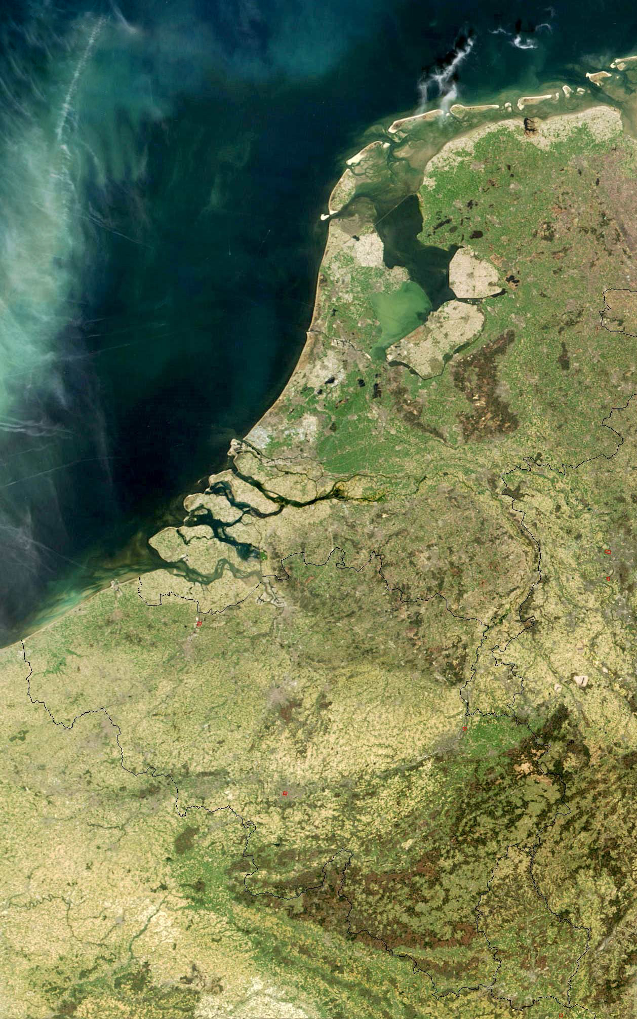
Geography wrote the name first. The Low Countries are the downstream basin of three great rivers - Rhine, Meuse, and Scheldt - emptying together into the North Sea. The region sits low enough that without dykes and pumps roughly a quarter of the present-day Netherlands would be under water. The Romans called the southern half of it Germania Inferior, which means exactly the same thing as Nederland. The pattern of settlement has always followed the water: cities founded where rivers braided, where boats could load and unload, where mills could be turned. Today the cluster of Belgian, Dutch, and Luxembourgish cities packs around 30 million people into a footprint smaller than Indiana, making this one of the densest places on Earth - a density medieval merchants would recognize, since the Low Countries rivaled northern Italy as Western Europe's most crowded region as early as the 12th century.
Why Trading Towns Beat Kings
There is a peculiar thing about Low Countries history that explains everything that followed. The cities here were strong before the rulers were. Guilds and councils ran most of the towns, and the figurehead lord above them was bound by detailed contracts about what he could and could not demand. When that lord wanted money he had to ask the merchants for it, and the merchants - Flemish, Brabantian, Hollandic - knew exactly how much leverage that gave them. The cumulative effect, over centuries, was to produce a political culture that resisted absolutism more stubbornly than almost anywhere else in Europe. By the 14th and 15th centuries, when the Valois Dukes of Burgundy gathered the patchwork of fiefs into one administration, the region was already the cultural and economic engine of northern Europe - producer of Early Netherlandish painting, the Franco-Flemish polyphony that musicians at every European court demanded, and the financial instruments that would later make Amsterdam the heart of world commerce.
The Split That Lasted
In 1581 the seven northern provinces declared independence from Habsburg Spain. The ten southern provinces stayed Catholic and stayed under Madrid. The Eighty Years' War formalized what would become, eventually, two separate countries: the Dutch Republic to the north, the Spanish (then Austrian) Netherlands to the south. The Latin names made the split sound symmetrical - Belgica Foederata for the rebellious north, Belgica Regia for the loyal south. When Belgium finally separated from the briefly reunited Kingdom of the Netherlands in 1830, the new country took the southern half of that Latin name. The northern half kept Nederland. Centuries of doctrinal argument, a hundred sieges, and the slow accumulation of habit had produced two distinct nations from one historical region - and a third, Luxembourg, that nobody quite knew where to put.
Twentieth Century, Twice Conquered
The Low Countries' geography that had made them rich also made them a corridor. In August 1914 Germany invaded Belgium and Luxembourg as the opening move of what became the First World War, on the cynical theory that going around the French border defenses would be quicker than going through them. Tens of thousands of Belgian soldiers and civilians would die before the war ended. In May 1940 Hitler did it again, this time also taking the Netherlands, for the same reason and with the same speed. The three countries spent five years occupied and their governments-in-exile in London. Out of that occupation came something nobody had predicted: in 1944, while still exiled, they signed the London Customs Convention - the agreement that became the Benelux Economic Union and, in time, the model for the European Economic Community. The region that had been invaded twice in 26 years invented, almost first, the framework that was meant to make such invasions impossible again.
What The Old Name Still Holds
The political grouping that the EU calls Benelux is the same set of lands that medieval clerks called de Lage Landen. The borders have moved, the languages have sorted themselves, the religions have drifted into a quiet secularism that 16th-century Calvinists and Catholics would not have understood. But the shape of the place - delta, dyked, crowded, mercantile, multilingual - is the shape it has been for as long as anyone has been writing about it. The Bernlef who sang Christian psalms and pagan verses in the 8th century and the Wachtendonck monks who copied 22 psalms by candlelight a hundred years later inhabited the same wet, river-cut country that the train from Amsterdam to Brussels crosses in two hours today. The Low Countries are not a country and never quite were. They are something older and stranger: a region that managed to keep being the same thing while everything political around it changed.
From the Air
The Low Countries center on roughly 52 N, 5 E, but the historical region extends from northern France through Luxembourg to the German border. Cruise the corridor between Amsterdam (EHAM) and Brussels (EBBR) at 6,000 feet for a panoramic sense of the Rhine-Meuse-Scheldt delta - polders, canals, ship channels, and the linear cities they made possible. Schiphol, Brussels, Eindhoven (EHEH), Antwerp (EBAW), and Maastricht (EHBK) form a dense airfield network. On clear days you can see the North Sea, Brussels, and the German Rhineland in a single hour of cruise.