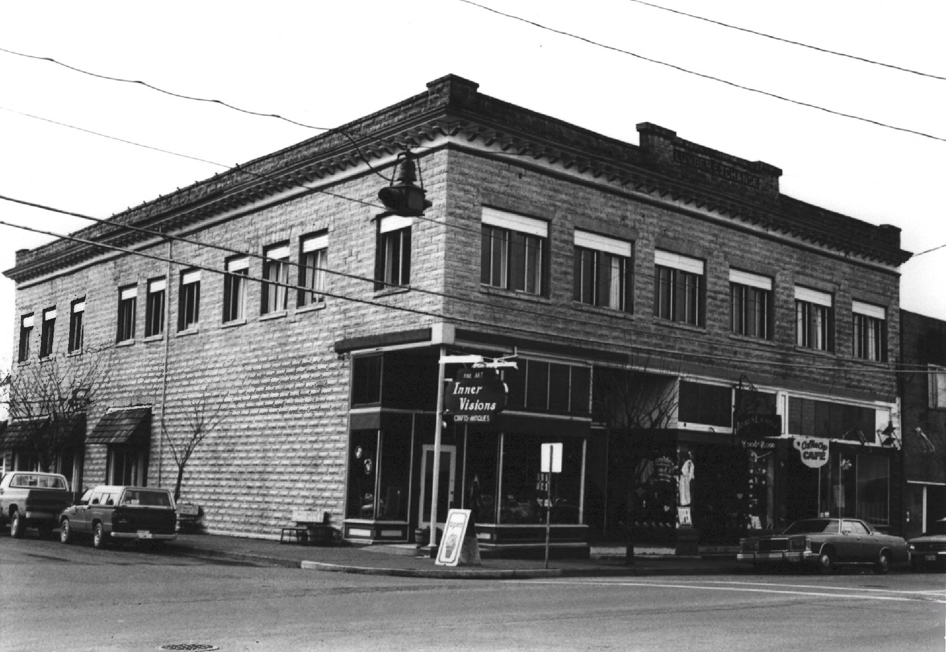
Lumber Exchange Building (South Bend, Washington)
The raiders came by steamboat. On February 5, 1893, a group of South Bend citizens boarded two vessels, sailed to the tiny hamlet of Oysterville, and physically seized the Pacific County records from the courthouse. They loaded the documents onto the boats and brought them back to South Bend, making it the county seat by force. That kind of brash confidence defined the town during its boom years, when sawmills produced a million board feet of lumber and a million shingles every day, when the population surged from 150 to 3,500 in half a decade, and when someone decided that this muddy waterfront settlement on Willapa Bay deserved a proper masonry building. In 1907, the Lumber Exchange Building rose on U.S. Route 101, the most substantial structure in a district of small wooden storefronts. It would stand for nearly a century before its facade fell onto the highway.
Built on Sawdust and Ambition
South Bend was founded in 1869 by the Riddell brothers, Valentine and John, who recognized an ideal spot for harvesting the abundant coastal forest and floating logs downriver to their sawmill. The town grew steadily but modestly until 1889, when the South Bend Land Company formed and speculators began arriving. By 1890, when South Bend incorporated, it had nearly 900 residents. Five years later, it had 3,500. The Northern Pacific Railroad reached the area in 1895, tapping the rich timberland surrounding the town and supercharging an economy already running hot on lumber and shingles. The Lumber Exchange Building, completed in 1907, was a two-story concrete block commercial structure that stood at a prominent intersection on South Bend's main waterfront thoroughfare, facing the Willapa River. In a district where nearly everything was built of wood - the very commodity that made the town wealthy - its masonry construction was a statement: South Bend intended to last.
The Bust That Lingered
Boom towns rarely age gracefully, and South Bend was no exception. The Panic of 1893 deflated the speculative bubble that had inflated the town's population and land prices. Many of the newcomers left as quickly as they had arrived. The lumber industry endured, and the county seat designation kept government jobs in town, but South Bend never recaptured its peak population or its peak ambitions. The Lumber Exchange Building persisted through the slow decades, its concrete block walls holding firm while the town's economy shifted beneath it. Lumber declined; oysters rose. South Bend began calling itself the Oyster Capital of the World, a title rooted in the extraordinary productivity of Willapa Bay, where roughly one in six oysters consumed in the United States is harvested. The building that had been a monument to timber found itself in a town that now smelled more of brine than sawdust.
A Place on the Register, Then the Ground
On May 19, 1988, the Lumber Exchange Building was added to the National Register of Historic Places, recognized as the most substantial masonry structure in South Bend's commercial district and a tangible link to the town's logging heyday. The Pacific County Historical Society had even used the building as temporary museum quarters in 1970. But recognition did not guarantee preservation. The building sat unoccupied for years, its granite footings and concrete block walls slowly deteriorating without maintenance. In February 2006, a real estate company called LANCO LLC announced plans to purchase the building as part of a development of two adjacent properties. The deal was contingent on a structural engineer confirming that the granite footings were still stable. That inspection never happened in time.
The Morning the Facade Fell
On May 7, 2006, part of the Lumber Exchange Building's facade collapsed onto U.S. Route 101. No one was injured - the building had been empty for years - but the highway that runs through downtown South Bend was suddenly blocked by a pile of century-old masonry. Three days later, on May 10, the rest of the building was razed. The site became a vacant lot on the town's main street, a gap in the row of buildings like a missing tooth. The demolition happened so quickly that there was little time for public debate about alternatives. Whatever the structural engineer might have found, whatever LANCO's development might have become, was rendered moot by gravity and neglect. South Bend lost one of its few remaining physical connections to the timber boom that built it. The Lumber Exchange Building, which had been built to prove that South Bend was more than a temporary camp, became instead a lesson in what happens when permanence is assumed rather than maintained.
From the Air
Located at 46.67°N, 123.81°W in South Bend, Washington, along the north shore of the Willapa River where it enters Willapa Bay. The building site sits directly on U.S. Route 101, which traces the waterfront through downtown South Bend. From altitude, South Bend is identifiable as the small town at the head of Willapa Bay where the river curves sharply. The Pacific County Courthouse, an ornate hilltop structure, is the town's most visible landmark from the air. Willapa Harbor Airport (2S9) is approximately 3 miles southwest. Astoria Regional Airport (KAST) lies about 40 miles south in Oregon. The building site itself is now a vacant lot and not distinguishable from the air, but the downtown waterfront strip along Route 101 is clearly visible.