Lut Desert
In 2005, NASA's Aqua satellite pointed its Moderate-Resolution Imaging Spectroradiometer at eastern Iran and recorded a land surface temperature of 70.7 degrees Celsius -- 159 degrees Fahrenheit. The instrument was measuring the Dasht-e Lut, a 51,800-square-kilometer expanse of salt, sand, and wind-sculpted rock that sprawls across the provinces of Kerman and Sistan-Baluchestan. By 2019, newer satellite data pushed the figure higher still, to 80.83 degrees Celsius. No other land surface on Earth has registered hotter. This is not a place that tolerates life casually. And yet people have been drawn to its edges for at least seven thousand years, leaving behind settlements, tools, and the trace of civilizations that rose and fell while the desert endured.
Anatomy of an Inferno
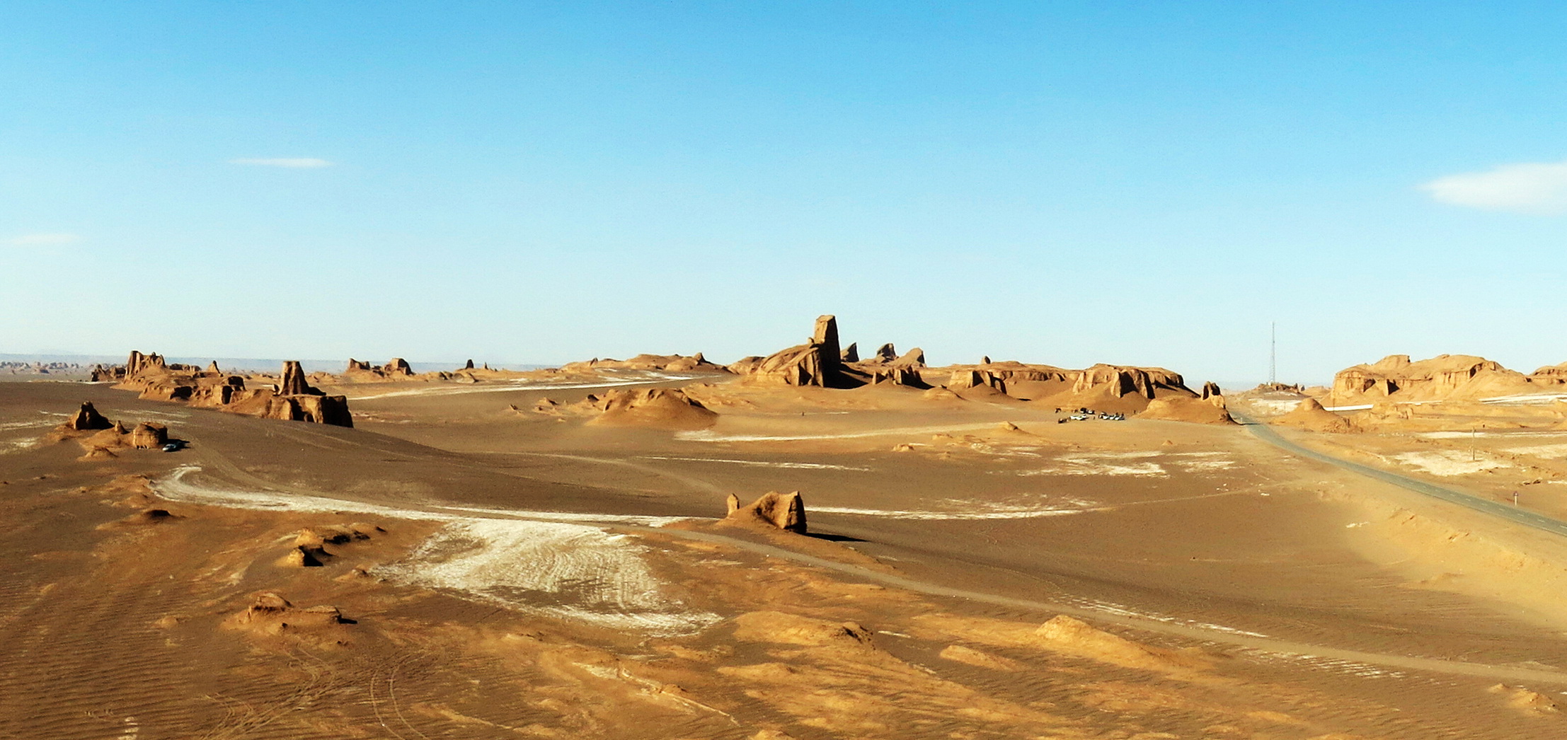
The Lut is Iran's second-largest desert, surpassed only by the Dasht-e Kavir to its north. Its geography is a study in extremes. The eastern portion is a low plateau of salt flats, some areas sinking to just 110 meters above sea level -- among the lowest elevations in Iran. The center of the desert is something else entirely: a vast field of parallel ridges and furrows called yardangs, sculpted by relentless wind erosion over millennia. These formations stretch more than 150 kilometers and rise up to 75 meters, their shapes so regular they look engineered. The distinction between air temperature and surface temperature matters here. While the satellite recorded a surface reading above 70 degrees Celsius, the air temperature at the same moment was likely between 30 and 50 degrees. But even that lower range is punishing. During the spring wet season, water descends briefly from the Kerman mountains to the west, only to evaporate almost immediately, leaving nothing behind but rock, sand, and crystallized salt.
Wind as Sculptor
The yardangs of the Lut Desert are among the largest and most dramatic on Earth. They form when prevailing winds, blowing consistently from a single direction, erode softer sedimentary rock while leaving harder ridges intact. Over thousands of years, the process carves the landscape into long, streamlined forms that align with the wind like the hull of a ship. From the air, the effect is striking: the central Lut looks like a plowed field on a planetary scale, each furrow a valley, each ridge a wall dozens of meters high. The wind does not stop at erosion. Sand, driven by the same persistent currents, accumulates into dune fields in the desert's western and southern reaches. The interplay between the yardangs, the salt flats, and the dunes creates a landscape of such geological variety that UNESCO cited it as a "superb example of ongoing geological processes" when inscribing the Lut on the World Heritage List on July 17, 2016.
Seven Thousand Years at the Edge
The Lut's extreme interior may be lifeless, but its fringes tell a different story. Archaeological surveys along the eastern flank of the Kerman range, near the desert's western margin, have identified eighty-seven ancient sites spanning from the fifth millennium BC to the late Islamic era. Twenty-three of these date to the Chalcolithic period and Bronze Age, when communities settled along seasonal water sources that drained from the mountains toward the desert basin. These were not nomadic camps but structured settlements, evidence that the Lut's margins supported sustained habitation for millennia. The people who lived there understood the desert's rhythms -- the brief spring flows, the seasonal winds, the brutal summers -- and built their lives around them. What drove them to the edge of one of the most hostile environments on the planet remains an open question, though the proximity of trade routes connecting the Iranian plateau to Central Asia and the Indus Valley likely played a role.
A Desert Seen from Space
From orbit, the Lut is unmistakable. Its yardang field appears as a dark, textured smear against the lighter tones of surrounding salt and sand. The salt flats gleam white, reflecting sunlight with an intensity that makes them visible even in low-resolution satellite imagery. NASA has returned to the Lut repeatedly since its initial temperature measurements, using it as a natural laboratory for studying extreme thermal environments and the limits of remote sensing. For pilots flying over eastern Iran, the Lut presents as a vast, empty canvas -- tan and white at lower altitudes, darkening to rust and shadow where the yardangs cast their long parallel lines. There are no settlements within the interior, no roads, no structures. It is one of the few places on Earth where the ground itself has been measured hotter than boiling water, a landscape that exists at the boundary of what instruments can record and what the human body can survive.
From the Air
Located at 30.26N, 59.24E in southeastern Iran, the Lut Desert covers approximately 51,800 square kilometers across Kerman and Sistan-Baluchestan provinces. From cruising altitude, the yardang field in the central desert is visible as a distinctive dark, ridged texture oriented with prevailing winds. Salt flats in the eastern section appear as bright white expanses, some as low as 110m above sea level. There are no airports within the desert interior. The nearest major airport is Kerman Airport (OIKK) to the west, approximately 200 km from the desert center. Zahedan International Airport (OIZH) lies to the southeast. Pilots should note extreme surface heating during summer months. The desert is bounded by the Kerman mountain range to the west and extends toward the Afghan border to the east.