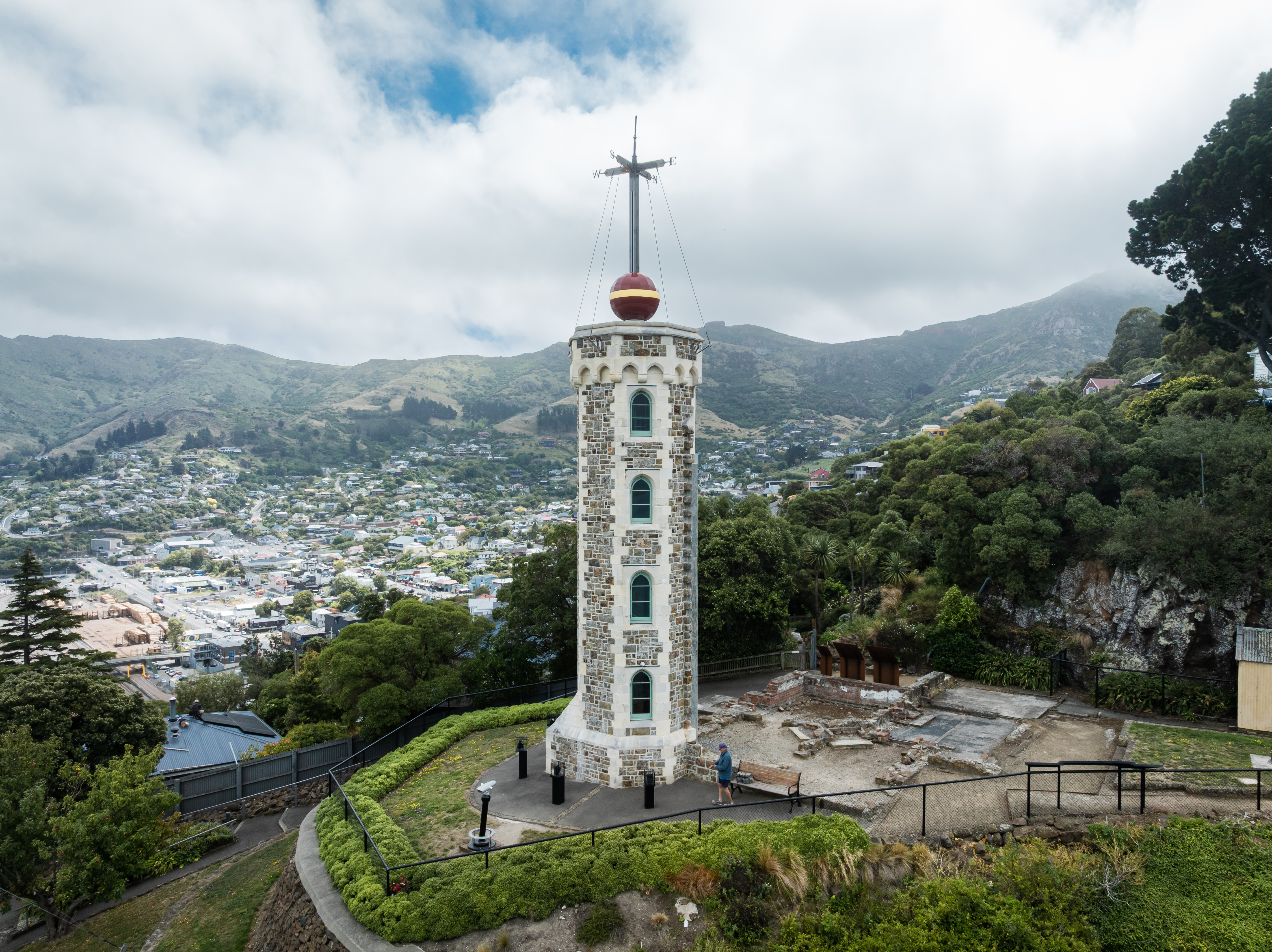
Lyttelton Timeball Station
Every day at one o'clock, a large painted ball dropped down a mast on the hillside above Lyttelton Harbour. Sailors offshore would see it fall and set their chronometers accordingly, because at sea, knowing the exact time was the difference between reaching port and missing a continent. An error of just four seconds translated to 6,000 feet of actual distance at the equator. The Lyttelton Timeball Station, built in 1876, was New Zealand's third such device after Wellington and Dunedin, and it performed this precise, unglamorous, essential function for nearly six decades. By the time it stopped operating on 31 December 1934, radio signals had made the time ball obsolete. But the station on the hill remained, a stubborn landmark that outlasted its purpose - until the earthquakes came.
Peacock's Persistence
The station owed its existence to John Thomas Peacock, a businessman who arrived in Lyttelton in 1844, six years before the Canterbury settlers' First Four Ships. Peacock built the port's first substantial wharf and became one of Lyttelton's most established figures. He first proposed a time ball station as a Member of the House of Representatives, but Parliament rejected the idea. Undeterred, he raised it again through the Canterbury Provincial Council in 1870, where it finally found support. Peacock understood something practical: Lyttelton was Canterbury's lifeline to the outside world, and the ships that used its harbour needed accurate timekeeping to navigate safely. The station was not a vanity project. It was infrastructure for an era when the sea was the only highway, and a clock that drifted by seconds could send a ship onto rocks.
Flags, Balls, and the March of Technology
The time ball was only part of the station's communication system. A flag signaling apparatus predated the ball and outlasted it, sending messages to ships in the harbour and relaying news of arrivals to the town. The flags continued operating until 1941, when the army took over the station during World War II. After the war, the Harbour Board used the building for a time, but by the 1960s it stood empty - a hilltop relic of a communication technology that had been superseded twice over, first by radio and then by electronics. Heritage New Zealand registered it as a Category I historic place in 1983, noting that Lyttelton's was one of only five time ball stations still in working order anywhere in the world, and the only one remaining in New Zealand. The building had become significant precisely because everything it represented had vanished elsewhere.
The Ground Shifts
The Canterbury earthquake sequence began on 4 September 2010 and continued for months. The Lyttelton Timeball Station sustained significant damage in the initial quakes and their aftershocks, its Victorian masonry unable to withstand the repeated shaking. On 13 June 2011, a magnitude 6.4 aftershock finished what the earlier tremors had started: the station collapsed. Heritage New Zealand arranged for a careful deconstruction under archaeological authority, recording and cataloguing every element as it was removed from the rubble. The time ball mechanism was salvaged. The foundations were exposed and documented. The heritage listing was subsequently withdrawn - the building it protected no longer existed. Lyttelton, a town defined by its historic character, had lost one of its most recognizable landmarks in a matter of seconds.
Rebuilt from Stubbornness
The collapse might have been the end of the story, but Lyttelton is a town that holds on to things. On 25 May 2013, a million-dollar donation kicked off a fundraising campaign to rebuild the tower and restore the time ball. Community support gathered momentum. The tower reconstruction took place between July 2017 and November 2018, and the rebuilt station reopened to the public in November 2018. It is not the original - that was reduced to rubble and catalogued fragments. But it stands on the same hill, looks over the same harbour, and drops its ball at the same appointed hour. The rebuilt station serves no navigational purpose whatsoever. Ships have GPS now. What it serves is something harder to quantify: a community's insistence that certain things should remain, that a skyline has a memory, and that rebuilding after destruction is itself a kind of timekeeping - marking the hours between what was and what comes next.
From the Air
Located at 43.61°S, 172.73°E on the hillside above Lyttelton Harbour, clearly visible as a tower on the slope above town. The rebuilt station is a recognizable visual landmark from the air. Lyttelton sits within the caldera of an extinct volcano on Banks Peninsula. Nearest major airport: Christchurch International (NZCH), approximately 12 km to the northwest via the road tunnel under the Port Hills. Best viewed at 1,500-3,000 ft for detail of the tower and harbour setting.