Madeira River
The Portuguese named it the Madeira -- the Wood River -- for the massive tree trunks that its current ripped from the banks and carried downstream like battering rams. Before them, the Topinambes people called it the Cuyari, and it was by this river that their nation passed into the Amazon. Today the Madeira remains the Amazon's largest tributary, delivering roughly 15 percent of the entire basin's water and draining a catchment area almost equal in size to France and Spain combined. Where the Beni and Mamore rivers merge near the Bolivian border, the Madeira is born at a volume that already rivals the Congo.
Born from the Andes, Bound for the Amazon
The Madeira's headwaters reach deep into South America. From the northeast slopes of the Andes between Santa Cruz de la Sierra and Cusco, through the southwestern plains of Mato Grosso, to the northern edge of the Chiquitos sierras, water gathers from half a dozen major rivers -- the Guapore, the Mamore, the Beni, the Madre de Dios -- each reinforced by dozens of lesser tributaries. All of these upper branches cross the Mojos and Beni plains, a vast lowland where 90,000 square kilometers flood to a depth of about one meter every wet season for three to four months. From the confluence that forms it, the Madeira flows northward along the Bolivia-Brazil border, then bends northeast through the Brazilian states of Rondonia and Amazonas before emptying into the Amazon. At its mouth lies the marshy archipelago of Ilha Tupinambaranas, where the river dissolves into a labyrinth of distributaries.
The Devil's Railroad
Waterfalls once blocked the Madeira between Guajara-Mirim and Porto Velho -- rapids with higher flow rates and greater drops than Africa's Boyoma Falls. For Bolivia's rubber exporters, these cascades were a commercial nightmare, cutting off their landlocked production from Atlantic markets. In the 1870s, the American colonel George Earl Church won concessions from Brazil and Bolivia to build a railroad around the falls, but malaria, accidents, and violence defeated two attempts. Construction finally succeeded between 1907 and 1912. The cost in human life was staggering: estimates of workers who died range from 6,000 to 10,000, earning the line its grim nickname -- the Devil's Railroad. The Madeira-Mamore Railroad was inaugurated on April 30, 1912, precisely as Asian rubber plantations were destroying the Amazonian monopoly. By 1972, when Brazil completed the BR-364 highway, the railroad was abandoned.
A Working River
The Madeira rises more than 15 meters during the rainy season, and ocean-going vessels can ascend it over 1,000 kilometers to the vicinity of Porto Velho. Today it is one of the Amazon basin's busiest commercial waterways. Close to four million tons of grain -- mainly soy and corn -- are loaded onto barges at Porto Velho, where Cargill and Amaggi operate loading facilities, then shipped downstream to the ports of Itacoatiara and Santarem for export to Europe and Asia aboard Panamax freighters. Fuel refined at the Petrobras REMAN refinery in Manaus travels upstream to supply the states of Acre, Rondonia, and parts of Mato Grosso. Because Manaus is effectively landlocked for ground logistics, the 1,225-kilometer barge route along the Rio Negro, Amazon, and Madeira is a critical supply line connecting the city's industrial district with the rest of Brazil.
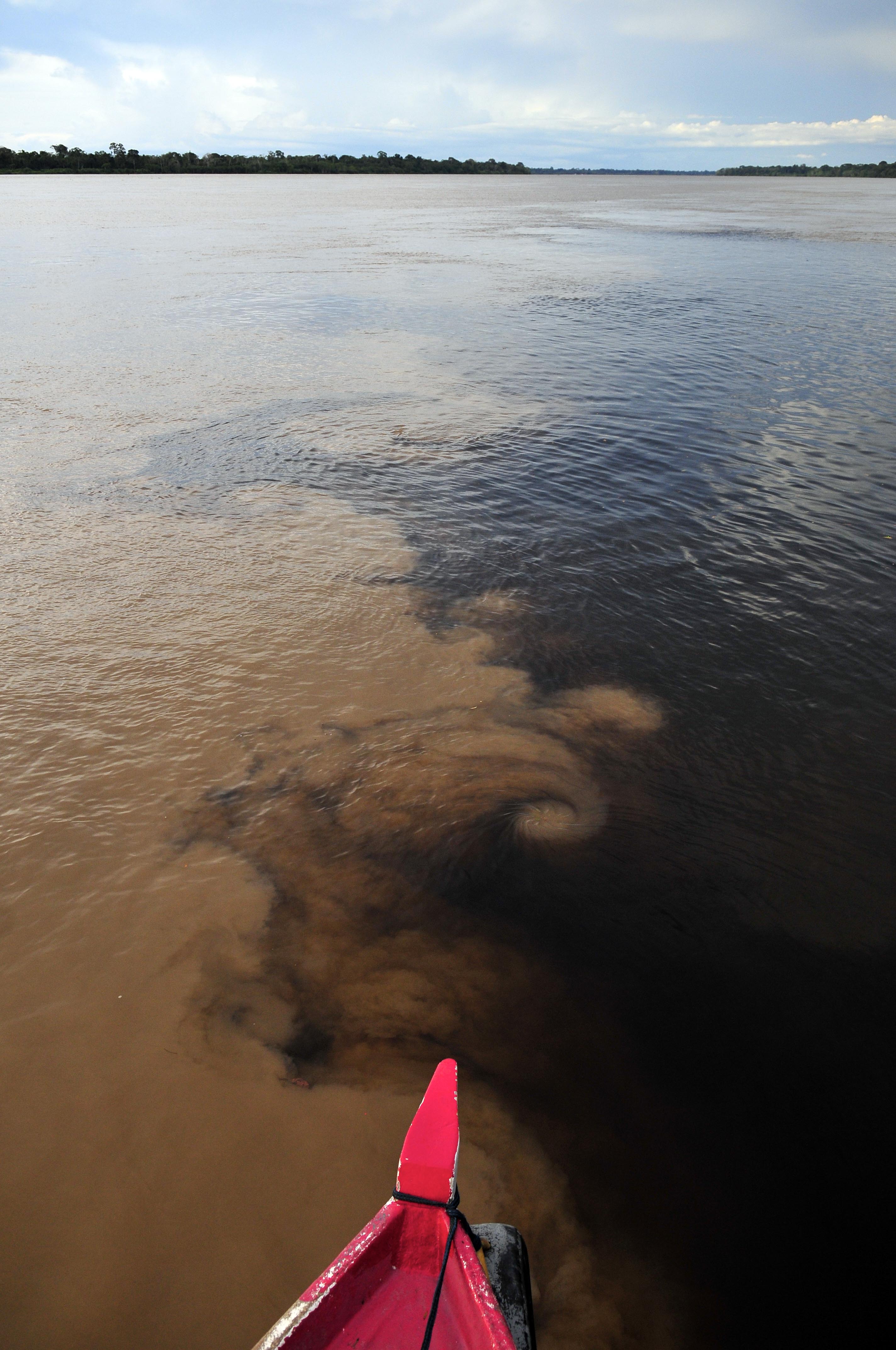
Turbid Waters, Extraordinary Life
Sediment washed from the Andes makes the Madeira a classic whitewater river -- turbid and tea-brown -- though some of its tributaries run as clearwater or blackwater streams. This murky current supports one of the richest freshwater ecosystems on Earth, with more than 900 documented fish species. The Bolivian river dolphin, either a subspecies of the Amazon river dolphin or a separate species depending on the taxonomist, lives exclusively in the upper Madeira system, isolated above the former rapids long enough for evolution to chart its own quiet course. The 283,117-hectare Rio Madeira Sustainable Development Reserve, created in 2006, extends along the north bank opposite the town of Novo Aripuana -- one of the Amazon's largest protected riverine areas.
Dammed and Diminished
Two major hydroelectric dams -- the Santo Antonio and the Jirau, both approved in 2007 -- now harness the river near Porto Velho. Their run-of-the-river designs avoid impounding massive reservoirs, and both include fish ladders intended as environmental remediation. But the Santo Antonio Dam's reservoir has already drowned the historic falls of Teotonio and San Antonio -- rapids that had defined the river's character for millennia, now silent beneath still water. If those fish ladders fail, several valuable migratory species face near-extinction. The tension is not subtle: a river that once defeated railroad builders with its power is now expected to submit to turbines, and the question of what is lost when a wild river is tamed has no easy answer.
From the Air
The Madeira River is visible as a wide, sediment-brown ribbon flowing northeast through the green canopy of Rondonia and Amazonas states. Coordinates near the Beni-Mamore confluence: 10.38S, 65.39W. Porto Velho (SBPV) sits along the river's upper course. Downstream, the river passes Novo Aripuana and joins the Amazon east of Manaus. Best viewed from 10,000-15,000 feet where the full width and sinuous meanders become apparent. The contrasting water colors at tributary confluences -- brown Madeira meeting dark blackwater or clear streams -- are striking from altitude.