Maeshowe
For a few days each December, the setting sun sends a beam of light down a 36-foot stone passage and into the heart of a 5,000-year-old chamber on Orkney's Mainland. The alignment is precise, deliberate, and deeply unsettling in what it implies about the people who built Maeshowe around 2800 BC. These were farmers and herders who used grooved ware pottery and raised cattle on a treeless plain. They also engineered a structure whose stone jointing, according to one scholar, "rivals that of the Great Pyramid." The mound sits in a flat landscape near the Loch of Harray, looking like nothing more than an unusually symmetrical grassy hill -- until you crawl inside.
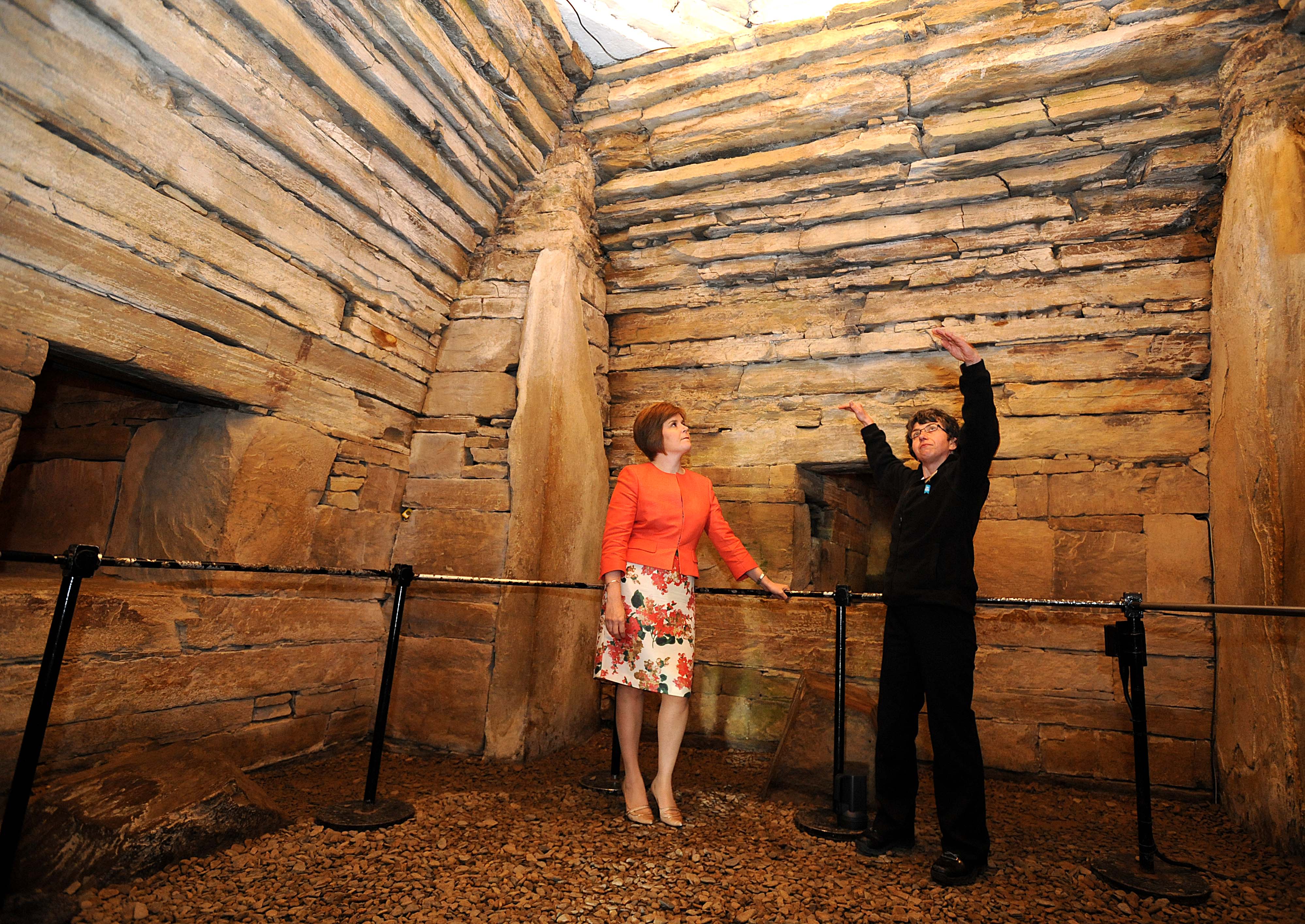
Engineering in Stone
The mound is 115 feet in diameter, encircled by a ditch, and hides a complex of passages and chambers built from carefully crafted flagstone slabs weighing up to 30 tons. The entrance passage runs 36 feet to a nearly square central chamber measuring roughly 15 feet on each side. Visitors must stoop or crawl to enter -- the passage is deliberately low. Inside, the chamber rises into a corbelled vault, the walls transitioning from flat slabs to overlapping stones that create a beehive shape. Massive angled buttresses occupy each corner, rising into the vaulting. The original roof may have reached 15 feet or higher. Archaeologist Colin Renfrew estimated that construction required at least 100,000 man-hours, though other estimates run lower. What remains unarguable is the sophistication: the builders positioned the entrance corridor so precisely that sunlight reaches the back cell only during the winter solstice, an effect shared with Newgrange in Ireland, suggesting deep connections between Neolithic cultures across the British Isles.
The Norse Broke In
Maeshowe sat undisturbed for millennia until Norse invaders reached Orkney in the 9th century. According to the Orkneyinga saga, Vikings including Earl Harald Maddadarson broke into the tomb around the 12th century. What they found -- or did not find -- remains debated. What they left behind is extraordinary: more than 30 runic inscriptions carved into the chamber walls, the largest single collection of such carvings in the world outside Scandinavia. The inscriptions range from the mundane ("Ingigerth is the most beautiful of all women," reads one, beside a carved figure) to boasts about treasure. Some archaeologists believe the Norse actually reused the tomb, pointing to evidence that the external wall was rebuilt in the 9th century. The "treasure" later looters reported finding may have been Norse offerings rather than Neolithic grave goods -- indeed, no human remains have ever been confirmed at Maeshowe, raising the possibility that this was never a tomb at all, but an observatory, a calendar, or a ceremonial space.
A Sacred Landscape
Maeshowe does not exist in isolation. It anchors one end of a Neolithic ritual landscape that stretches across the isthmus between the Lochs of Stenness and Harray, connecting to the Ring of Brodgar, the Standing Stones of Stenness, and the nearby Barnhouse Settlement. A Neolithic "low road" links these sites, and the entrance of one Barnhouse structure faces directly toward Maeshowe's mound. The so-called Barnhouse Stone, standing in a field 700 metres away, aligns perfectly with Maeshowe's entrance passage. This concentration of Neolithic monuments is rivalled in Britain only by the complexes around Stonehenge and Avebury, and in 1999 the entire group was designated a UNESCO World Heritage Site under the name "Heart of Neolithic Orkney." These were not isolated structures but components of a designed landscape, built by communities who invested enormous labor into marking their relationship with the sky, the seasons, and the dead.
Rediscovery and the Reckless Antiquarian
The modern opening of Maeshowe in July 1861 was the work of James Farrer, an antiquarian and Member of Parliament described by one historian as possessing "a rapacious appetite for excavation matched only by his crude techniques, lack of inspiration, and general inability to publish." Farrer broke through the roof of the entrance passage, found it choked with debris, then attacked the top of the mound. Over several days he emptied the main chamber entirely, discovering the runic inscriptions that proved Norse raiders had preceded him by centuries. His methods destroyed context that modern archaeology would have treasured, but the inscriptions he revealed transformed understanding of Viking activity in Orkney. Today, visitors depart from the Heart of Neolithic Orkney Visitor Centre in Stenness village, opened in 2017, taking a shuttle bus to the chambered cairn. Tours are limited to groups of 16, a concession to the fragility of a structure that has somehow endured five thousand years of Orkney weather and only one Victorian antiquarian.
From the Air
Located at 59.00N, 3.19W on Mainland Orkney, Scotland. The mound appears as a symmetrical grass-covered hill in flat farmland between the Loch of Harray and Loch of Stenness. The Ring of Brodgar stone circle is visible approximately 1 nm to the northwest. Nearest airport: Kirkwall (EGPA), approximately 8 nm to the east. Best viewed at 1,000-2,000 ft AGL to appreciate the landscape context.