Maiden Castle, Dorset
From the air, Maiden Castle looks like a green fingerprint pressed into the Dorset countryside. Its concentric rings of ramparts and ditches ripple outward across a hilltop southwest of Dorchester, enclosing an area of roughly 47 hectares. No photograph conveys the scale. This is the largest Iron Age hillfort in Europe, and standing inside its grass-covered walls, the modern world disappears entirely. The wind carries nothing but birdsong and the distant sound of sheep.
Deeper Than Iron
Human activity on this hilltop stretches back far beyond the Iron Age. A Neolithic causewayed enclosure was built here around 3500 BC, one of the earliest communal gathering places in southern England. Adjacent to it, a bank barrow nearly 550 metres long was constructed, one of the longest such monuments in Britain. Around 1800 BC, during the Bronze Age, the site was used for growing crops before being abandoned for centuries. When people returned around 600 BC, they built something different: a fortified settlement ringed by a single ditch and rampart, unremarkable by the standards of British hillforts. What happened next was not.
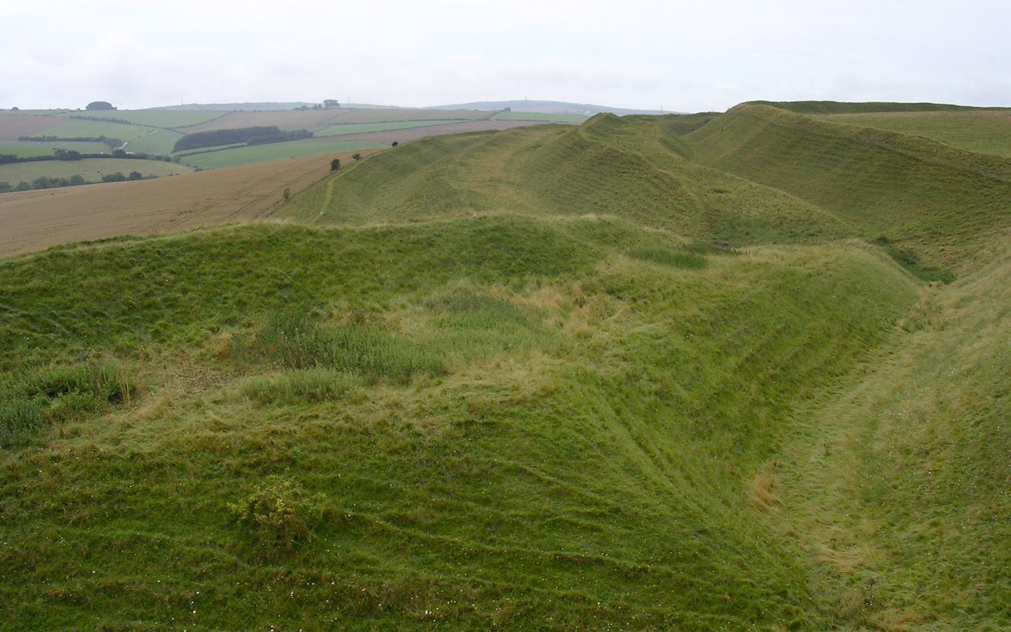
The Fortress Grows
Around 450 BC, the hillfort was dramatically expanded. The enclosed area roughly tripled, and the defences were elaborated into the extraordinary system visible today: multiple concentric ramparts rising to heights of six metres, separated by deep ditches, with elaborately twisted entrance corridors designed to slow and expose attackers. The Durotriges tribe occupied the fort, and archaeological evidence suggests a substantial settlement within, with streets, storage pits, and roundhouses. The scale of the defences speaks to an age of competition and conflict between tribal groups across southern Britain, each vying for control of territory and resources.
The Roman Hammer
In AD 43, the Roman legions arrived. The archaeologist Sir Mortimer Wheeler, who excavated Maiden Castle in the 1930s, described finding a "war cemetery" near the eastern entrance containing the remains of defenders who had fallen in what he interpreted as a dramatic Roman assault. One skeleton bore a Roman ballista bolt embedded in its spine. Wheeler painted a vivid picture of the Second Legion Augusta, likely under the future emperor Vespasian, storming the gates. Later archaeologists have questioned whether the assault was quite so cinematically violent, suggesting a more prolonged and less dramatic process of conquest. But the evidence of conflict is real, and the hillfort was abandoned as a settlement within a generation of the Roman arrival.
What the Romans Left Behind
The story does not end with conquest. In the late fourth century, when the Roman Empire was itself declining, a small Romano-Celtic temple was built within the old hillfort's walls, along with a two-roomed building that may have housed a priest or caretaker. The temple suggests that the ancient site retained spiritual significance even centuries after its abandonment as a fortress. After the Romans departed Britain, the hilltop returned to agriculture and silence. Today Maiden Castle is managed by English Heritage and remains open to anyone willing to climb the slopes. There are no turnstiles, no gift shops, no audio guides. Just the wind, the grass, and ramparts that have held their shape for two and a half thousand years.
From the Air
Located at 50.695N, 2.470W, roughly 2km southwest of Dorchester town centre. The concentric oval ramparts are dramatically visible from the air, appearing as nested green rings on the hilltop. Nearest airports: Bournemouth (EGHH) approximately 20nm east, Exeter (EGTE) approximately 40nm west. Best viewed from 1,500-3,000ft for the full pattern of ramparts and ditches to register.