Malakoff Diggins State Historic Park
They called the town Humbug at first, a name born from disappointment when prospectors followed a miner with a pocket full of nuggets only to find nothing. But the gold was there, locked in ancient riverbeds high on the San Juan Ridge. Extracting it would require washing away entire mountains with pressurized water cannons, creating the largest hydraulic mining site in California. Today, the massive artificial canyon at Malakoff Diggins stands as both monument to Gold Rush ingenuity and scar from an environmental disaster that triggered one of America's first environmental protection measures.
Water Against Mountains
By 1853, the easy gold had vanished from Sierra streams. Miners discovered that ancient river channels, now elevated hundreds of feet above modern waterways, contained vast deposits of gold-bearing gravel. The solution was hydraulic mining: building dams high in the mountains, channeling water through miles of wooden flumes, and blasting hillsides with pressurized jets called monitors. The force of these water cannons could toss a fifty-pound rock like a cannonball or kill a person instantly. At Malakoff Diggins, seven giant monitors worked around the clock by 1876, their jets carving a canyon that eventually stretched over 7,000 feet long, up to 3,000 feet wide, and nearly 600 feet deep in places. Over 300 Chinese workers labored alongside European immigrants to operate the massive enterprise.
Rise of North Bloomfield
The mining operation spawned a boomtown. By 1857, the settlement had grown to 500 residents who renamed it Bloomfield to escape the undignified original name. When California's postal service noted a conflict with another Bloomfield, the town became North Bloomfield. By 1876, the population swelled to around 2,000, with daily stagecoach service connecting residents to the outside world. In 1880, electric lights illuminated the mine, and the world's first long-distance telephone line was developed to service the operation, running from French Corral through North Bloomfield to Bowman Lake. For a brief moment, this remote mining camp sat at the cutting edge of technology.
Downstream Disaster
The hydraulic mining that built North Bloomfield was destroying communities downstream. The Yuba and Sacramento rivers ran thick with sediment. Marysville and Yuba City found themselves buried under feet of mud and debris. Sacramento flooded repeatedly. Thousands of acres of rich farmland disappeared under mining tailings. By 1883, San Francisco Bay was filling with silt at an estimated rate of one foot per year. Valley farmers fought back in court, and on January 7, 1884, federal judge Lorenzo Sawyer ruled against the North Bloomfield Mining and Gravel Company in Woodruff v. North Bloomfield, effectively ending large-scale hydraulic mining in California. The decision stands as one of America's first environmental protection measures.
Ghost Town to State Park
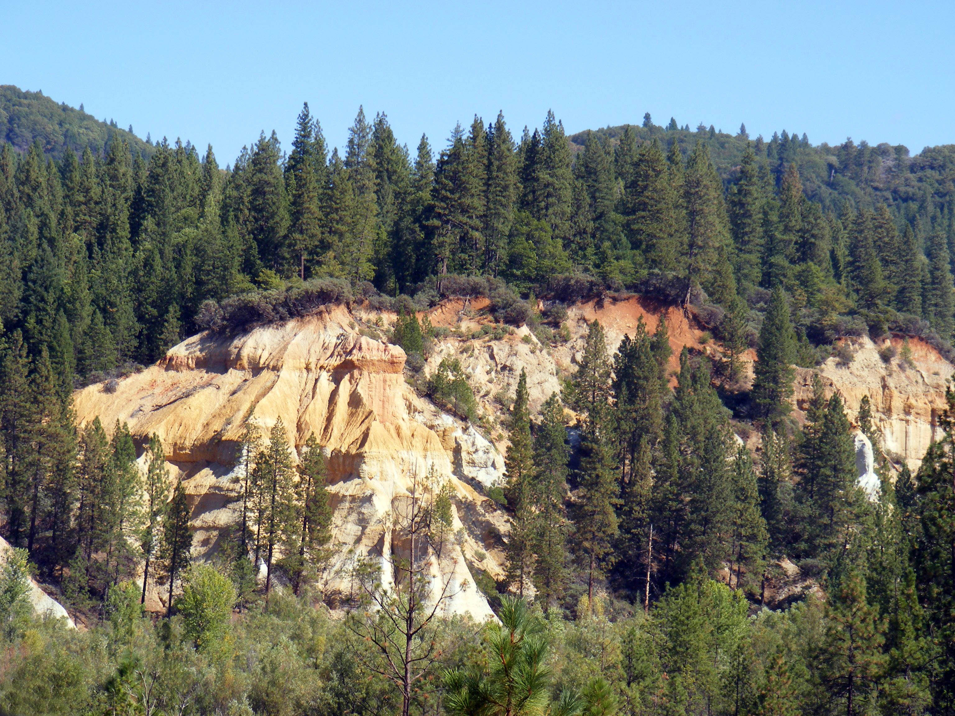
After the court ruling, North Bloomfield slowly emptied. The massive monitors fell silent, and the artificial canyon began its slow healing. Today, visitors can walk the streets of the preserved ghost town and peer into the Hiller Tunnel, through which water once roared on its way to blast the hillsides. The Rim Trail, Diggins Loop Trail, and other paths circle the enormous pit, where multicolored cliffs of red, yellow, and white sediment have weathered into strange formations. California established the park in 1965, preserving both the industrial archaeology and the cautionary tale of what happens when extraction proceeds without regard for consequence.
From the Air
Located at 39.363N, 120.924W in the Sierra Nevada foothills, northeast of Nevada City, California. The enormous hydraulic mining pit is visible from altitude as a distinctive scar in the otherwise forested landscape. The multicolored canyon walls contrast sharply with surrounding vegetation. Elevation approximately 3,400 feet. Nearest airports: Nevada County Air Park (O17) approximately 10nm southwest, Truckee Tahoe Airport (KTRK) approximately 25nm east. Weather can change rapidly in this mountain terrain.