Malibu Hydro
Somewhere on the steep forested slope across Jervis Inlet from the Malibu Club, a 12-inch steel pipe carries water down 1,250 vertical feet from an alpine lake to a powerhouse perched just above the beach. A Pelton wheel spins. A generator hums. Electricity travels through a submarine cable that runs two miles along the fjord bottom, surfaces on the other side, and lights up a camp that has no road, no grid connection, and no other reliable power source. The Malibu Hydro System is a small piece of engineering that solves a large problem: how do you electrify a place accessible only by boat or floatplane?
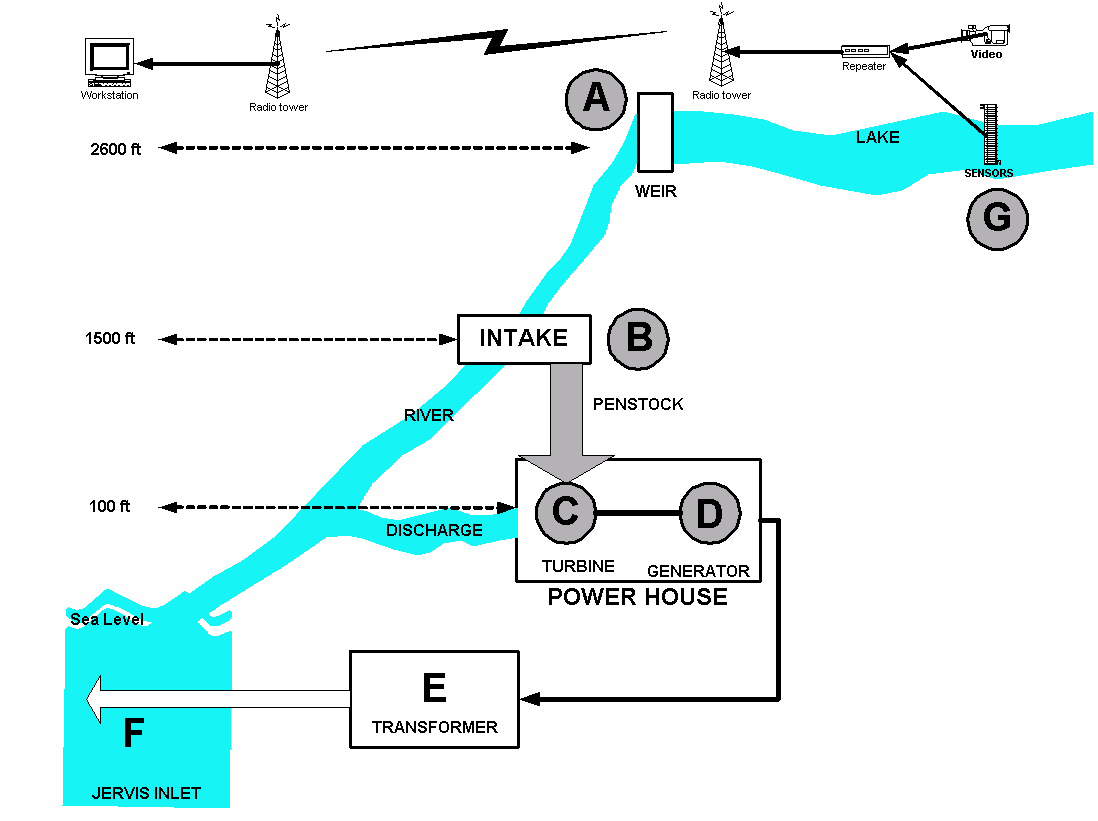
From Lake to Turbine
The system begins at McCannel Lake, a high alpine body of water sitting at 2,600 feet elevation directly across Jervis Inlet from the camp. At the lake's outlet, a small weir dam controls the discharge, maintaining lake levels while ensuring a minimum flow of 2 cubic feet per second continues down McCannel Creek to sustain the natural stream. From the lake, water flows down the creek to the 1,200-foot level, where a second weir creates a deep pool. Here the 12-inch penstock draws water at rates up to 7 cubic feet per second, channeling it into the steel pipe that drops steeply down to the powerhouse near shore level. The head -- the vertical distance the water falls -- provides the energy. Gravity does most of the work.
The Powerhouse and the Cable
Inside the powerhouse, the pressurized water strikes the buckets of a Pelton wheel, a type of impulse turbine designed for high-head, low-flow applications. The spinning wheel drives a generator that produces electricity at 600 volts. Transformers step that voltage up to 15,000 volts for transmission -- a necessary increase to reduce energy losses over the two-mile submarine crossing of Jervis Inlet. Three parallel underwater conductors carry the power across the fjord floor. On the Malibu side, another transformer steps the voltage back down to the 120 and 208 volts that light cabins, run kitchens, and charge devices at the camp. The entire chain, from alpine lake to kitchen outlet, runs on the pressure of falling water.
Powering a Place with No Road
The Malibu Club sits on the shore of Jervis Inlet at the entrance to Princess Louisa Inlet, one of the most remote and spectacular fjords on the BC coast. The nearest road is roughly 50 kilometers away. For decades after the camp was established, diesel generators provided electricity -- loud, expensive to fuel, and dependent on regular fuel deliveries by barge. Installation of the hydro system began in 2005, replacing fossil fuel with a year-round creek that runs on snowmelt and rain. The system produces clean power without the noise and logistics of diesel, a significant improvement for a camp that hosts young people who come partly for the experience of wilderness. McCannel Creek flows twelve months a year, giving the system reliability that seasonal creeks could not.
Small Scale, Smart Design
What makes the Malibu Hydro notable is not its size but its ingenuity. Every element of the design responds to the specific constraints of the site. The high alpine lake provides natural water storage, eliminating the need for a large reservoir. The steep terrain gives the system a massive head without requiring a long penstock. The submarine cable avoids the impossibility of running power lines through roadless, mountainous forest. Even the weir at the lake outlet is sized to preserve the creek's ecology while diverting enough water to generate useful power. It is the kind of infrastructure that disappears into its landscape -- no visible dam, no transmission towers, no roar of generators. Just clean power arriving quietly at the other end of a cable on the fjord floor.
From the Air
Located at 50.14°N, 123.88°W on the west shore of Jervis Inlet, directly across from the Malibu Club at the entrance to Princess Louisa Inlet. The powerhouse is near shore level; the source lake (McCannel Lake) is at 2,600 ft elevation on the steep slope above. The submarine cable runs roughly 2 miles (3 km) across Jervis Inlet. Best viewed at 3,000-5,000 ft. Nearest airport is Sechelt-Gibsons (CAP3), approximately 40 nm south. The Malibu Club dock and buildings are visible on the east shore of Jervis Inlet at the narrow entrance to Princess Louisa Inlet.