Mambilla Plateau
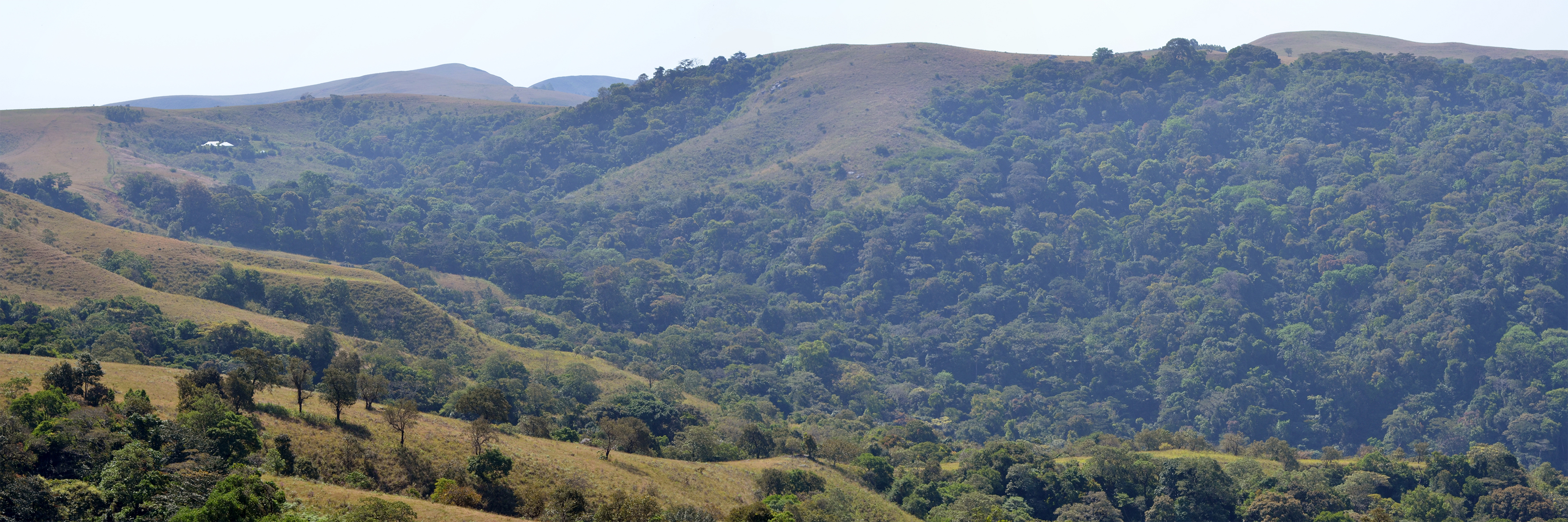
Daytime temperatures on the Mambilla Plateau hardly ever exceed 25 degrees Celsius. In a country where heat is the default condition, that single fact has shaped everything -- the tea farms, the cattle herds, the colonial ambitions, the ethnic tensions, and the improbable coolness of a place that feels nothing like Nigeria. Rising to an average of 1,600 metres above sea level in Taraba State, the Mambilla is the highest plateau in the country. Its peaks go higher still. Chappal Waddi, at 2,419 metres, is the tallest mountain in Nigeria and in all of West Africa. The plateau stretches 96 kilometres along its curved length, 40 kilometres wide, bounded by escarpments that drop 900 metres in places -- a highland world perched above the lowland heat.
The Roof of West Africa
The geography of the Mambilla Plateau is dramatic even by highland standards. Deep gorges cut through hilly terrain, and travellers pass from one panoramic view to the next with a regularity that would be exhausting anywhere less beautiful. The Donga River and the Taraba River both have their sources here, flowing outward from the plateau like arteries from a heart. Gembu, the largest town, serves as the administrative centre of Sardauna local government area. The plateau's southern and eastern escarpments stand along the Cameroonian border, while the northern escarpment and western slope face inward toward Nigeria. Granite surfaces only occasionally through a blanket of soil that covers the entire plateau -- a geological quirk that gives the landscape its soft, rolling character and made it irresistible to anyone who wanted to grow things.
German Trees and Nigerian Tea
Trees are conspicuously absent from much of the Mambilla Plateau -- except where humans planted them. Between 1906 and 1915, during the period of German administration of the Cameroons, colonial foresters introduced eucalyptus, which adapted readily to the altitude and cool climate. Nigerian government programs continued the planting. The result is a landscape of low, velvet-textured grass -- known locally as gwur grass, a ritual emblem of the Mambilla traditional religion -- punctuated by stands of foreign trees. The cool temperatures that keep the plateau treeless also make it the only region in Nigeria capable of growing tea on a commercial scale. Several plantations operate here, though the sector remains underdeveloped. Adjacent to the plateau lies the Ngel Nyaki Forest Reserve, a fragment of rare montane forest sheltering plant and animal species found nowhere else in West Africa. Gashaka Gumti National Park, Nigeria's largest protected area, borders the plateau to the north of Chappal Waddi.
The Bantu Who Stayed Home
Linguists and anthropologists have identified the 60,000-square-kilometre Mambilla region -- straddling the Nigeria-Cameroon borderlands -- as containing remnants of what researchers call "the Bantu who stayed home." When the great Bantu expansion carried languages and peoples southward across the African continent thousands of years ago, the Mambilla people remained. Their language, also called Mambilla, is still the first language for the vast majority of the plateau's residents. Fulfulde, the language of the Fulani herders who arrived during British rule, serves as a trade language. English is official. Since British occupation, waves of immigration have brought Yamba, Igbo, Hausa, and Banso communities to the plateau, mostly as traders and professionals. Only the Yamba established ancestral settlements; the rest maintain no claim to the land itself. Christianity and Islam gradually displaced the Mambilla traditional religion based on the Suu system, particularly after the 1960s, though gwur grass retains its ritual significance.
Cattle, Conflict, and an Unbuilt Dam
The abundance of lush green grass that makes the Mambilla Plateau beautiful also made it a magnet for cattle. Fulani herders brought their livestock during British rule, and the relationship between pastoralists and the indigenous Mambilla has been fraught ever since. Overgrazing has driven widespread erosion across the plateau, scarring the soft soil that gives the landscape its character. The tensions are not abstract -- they are disputes over land, livelihood, and whose claim runs deeper. Meanwhile, engineers have drawn plans for the Mambilla Hydroelectric Power Station near the Nigeria-Cameroon border for more than four decades. With an anticipated completion date that keeps receding, the project has been on the drawing boards since the 1980s. If built, it would be one of West Africa's largest hydroelectric installations. For now, it remains a promise unfulfilled -- fitting for a plateau where potential and neglect exist in roughly equal measure, where cool air and green grass mask real struggles over who controls the roof of Nigeria.
From the Air
Located at 7.33N, 11.72E in Taraba State, southeastern Nigeria. The plateau is unmistakable from altitude: a vast elevated tableland averaging 1,600 metres, bounded by steep escarpments dropping 900 metres to the surrounding lowlands. Chappal Waddi (2,419m), Nigeria's highest peak, is visible at the plateau's southern edge along the Cameroon border. Tea plantations and eucalyptus groves create distinctive patches of green. Nearest airport is Yola (DNYO), roughly 7 hours by road. The plateau's southern escarpment marks the Nigeria-Cameroon border. Gashaka Gumti National Park is visible to the north.