Manche Ch'ol
By 1710, the population of Manche Ch'ol living in the highland village of Belen had fallen to four. Everyone else -- the thousands who had once inhabited the rainforest settlements along the Cancuen and Sarstoon rivers, the traders who carried cacao and vanilla to Itza markets, the families whose children had died in the epidemic of 1678 -- was gone. Disease, hunger, and what the colonial records called "melancholy" had consumed them. The Manche Ch'ol were a Maya people who lived in the tropical lowlands of what is now southeastern Peten and northern Izabal in Guatemala, extending into southern Belize. Their story is not one of a single dramatic conquest but of a slow, two-century erasure accomplished by missionaries, slavers, disease, and finally forced relocation to a climate that killed those who survived everything else.
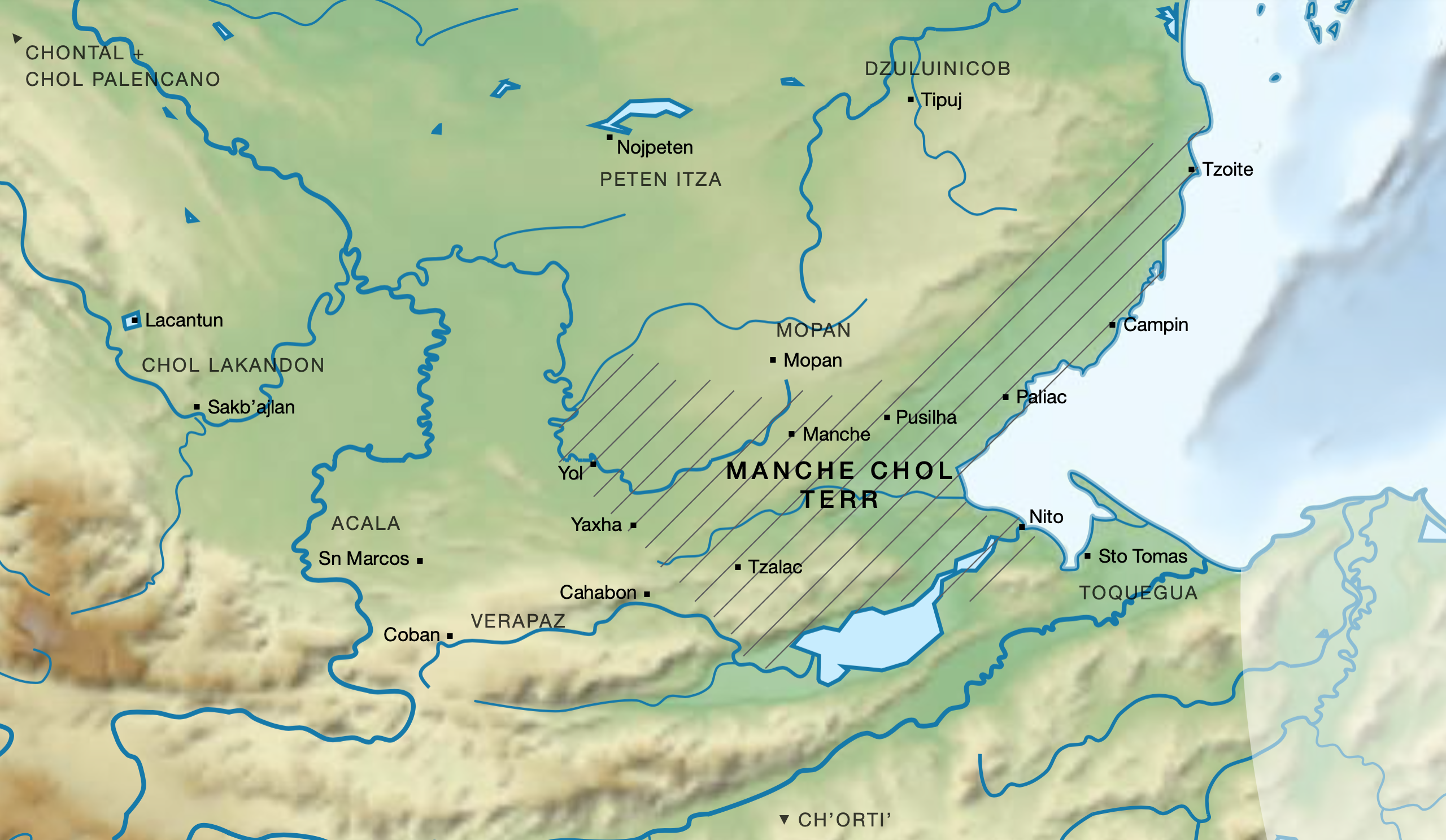
The Forest Between Empires
The Manche Ch'ol territory sat in a crescent stretching from the Cancuen River down to the Rio Dulce and up to the Sittee River, encompassing what is now southern Peten, northeastern Alta Verapaz, northern Izabal, and parts of Belize's Toledo and Stann Creek districts. Heavy tropical rainforest covered the land, criss-crossed by fast-flowing rivers and pockmarked by savannahs and swamps. Small farming settlements dotted the riverbanks, the largest being the eponymous Manche, estimated at around one hundred multigenerational households. Their neighbors included the Mopan Maya to the north, the fiercely independent Itza of central Peten to the northwest, and various Ch'olan and Yucatecan-speaking peoples on all sides. This placed the Manche at the intersection of multiple spheres of influence -- a borderland where trade, diplomacy, and violence overlapped constantly. They are believed to be descendants of Classic period Maya who built cities like Nim Li Punit, Copan, and Quirigua between roughly 250 and 900 AD.
Missionaries and the Uncaged Birds
Hernan Cortes crossed Manche Ch'ol territory in 1525 and described it as sparsely populated. For decades afterward, the Spanish largely left them alone. Dominican friars made first contact in 1603, beginning the long project of gathering scattered inhabitants into mission towns. By 1628, the Dominicans were tending to 6,000 Maya in the areas they had penetrated, and estimates of the total Manche Ch'ol population ranged from 10,000 to 30,000. But the mission towns attracted the attention of the Itza, who attacked them and fomented rebellion among the Manche. In the early 1630s, Itza and Mopan forces drove the Dominicans out for decades. When the friars returned in the 1670s, they found a people unwilling to stay converted. Friar Francisco Gallegos captured the frustration perfectly: trying to concentrate the Manche in mission towns, he wrote, was "like keeping birds in the forest without a cage." The Manche Ch'ol adopted Christianity quickly and abandoned it equally fast, retreating into the forest whenever Spanish demands became unbearable.
Squeezed from Every Side
By the 1670s the Manche Ch'ol were trapped between two kinds of exploitation. The Itza controlled the only local salt supply and enforced their trade monopoly through threats of armed reprisal, demanding cacao, annatto, and vanilla at prices they set unilaterally. From the other direction, Spanish colonial officials imposed compulsory trade at extortionate rates. In the late 1670s, Sebastian de Olivera, governor of Verapaz, forced one Manche town to purchase 70 machetes at two and a half times the market price, payable in cacao. Those who could not pay had their goods, clothing, poultry, and metal tools seized. Meanwhile, the Christianized Maya of Cahabon were fleeing Spanish control to live as apostates among the Manche -- a flow of refugees that alarmed colonial authorities and hardened their resolve to bring the territory to heel. In 1684, three Franciscan friars were killed during an expedition to Paliac that was likely driven more by cacao collection than evangelization. The friars were probably sacrificed by having their hearts cut out.
The Cold That Finished Them
In 1678, disease swept through the Manche Ch'ol settlements around San Lucas Tzalac, killing every child under six and nearly all those under ten. Over 400 people died in that area alone, and the survivors abandoned the mission towns for the forest. A rebellion in 1689 prompted the Spanish to begin forcibly relocating Manche Ch'ol to the Urran Valley in the Guatemalan highlands. The relocation was completed in 1697, shortly after the Spanish finally conquered the neighboring Itza. The surviving Manche were resettled in the villages of El Chol and Belen, near Rabinal -- a world away from the tropical lowlands they had inhabited for centuries. The abrupt shift from humid jungle to cold highlands proved devastating. The Spanish often failed to provide adequate clothing, and many died. By 1770, the Manche Ch'ol were effectively extinct, their abandoned territory reverting to wilderness. The few survivors -- perhaps 300 across the entire Urran Valley -- were gradually absorbed into the surrounding Q'eqchi' Maya population. In the early nineteenth century, a handful of people in Coban were still recorded as speaking Ch'ol. Then even that trace fell silent.
From the Air
The former Manche Ch'ol territory centered around 15.91N, 89.07W, spanning the lowland jungle between Lake Izabal and the Maya Mountains in eastern Guatemala and southern Belize. From 8,000-10,000 feet AGL, the area appears as dense, unbroken tropical forest cut by winding rivers -- the Cancuen, Sarstoon, and Rio Dulce prominent among them. Lake Izabal is visible to the north, and the Maya Mountains rise to the east along the Belize border. The nearest airports are Puerto Barrios (PBR) to the northeast and Flores (FRS) to the northwest. Expect heavy tropical vegetation, afternoon thunderstorms, and limited visual landmarks in the forest interior.