Mangla Dam
In 1960, India and Pakistan signed the Indus Waters Treaty, carving up the subcontinent's lifeblood by river. Pakistan gained the Jhelum, the Chenab, and the Indus itself, but gaining rights to water meant nothing without the infrastructure to hold it. The monsoon delivered billions of gallons each summer, then the rivers shrank to a fraction of their capacity during the growing season when farmers needed them most. Pakistan's entire irrigation system ran on the unregulated pulse of the Indus and its tributaries, and the agricultural yield suffered accordingly. The answer was concrete, clay, and earth on a colossal scale: the Mangla Dam, rising where the Jhelum carves through the hills of Azad Kashmir, 67 miles southeast of Islamabad.
An Engineering Colossus
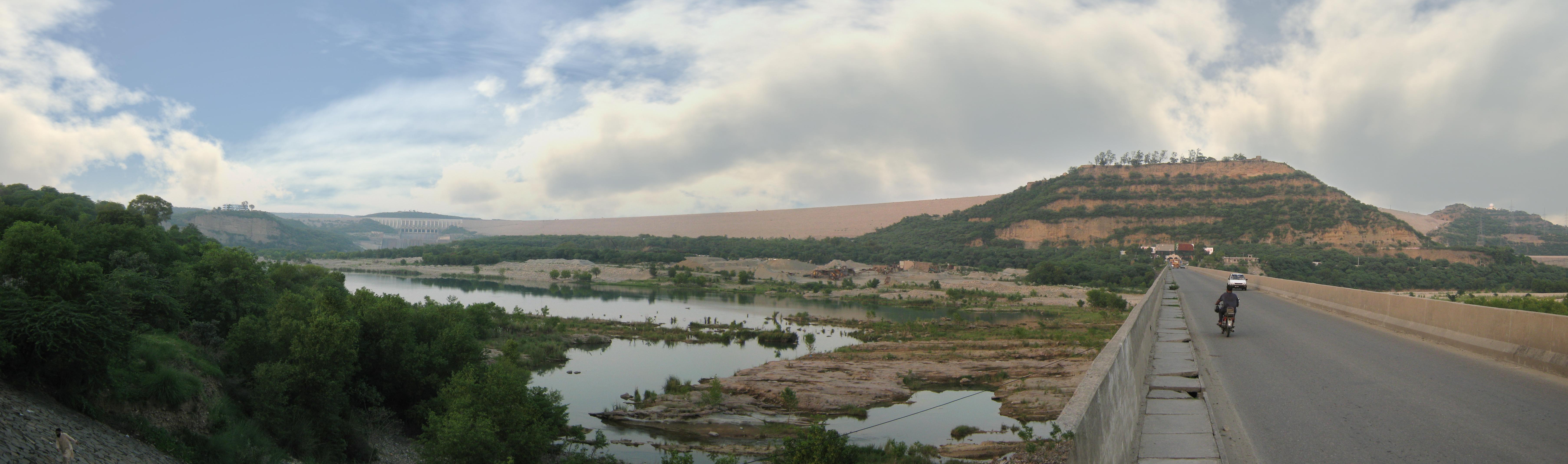
Construction began in 1961, with British firm Binnie & Partners leading the design under Geoffrey Binnie and a consortium of eight American companies, sponsored by the Guy F. Atkinson Company of South San Francisco, handling the build. By 1965, the main structure was complete: an earthfill embankment 454 feet high and 8,400 feet long, with a clay core braced by gravel and sandstone shoulders. The numbers beggar belief. Workers excavated 120 million cubic yards of material and filled 142 million cubic yards back in. The main spillway, a submerged orifice design with nine radial gates, can discharge 1.1 million cubic feet per second. Five steel-and-concrete-lined tunnels, each over 1,500 feet long, feed water to the powerhouse. Beyond the main dam, engineers built the Sukian dyke at 17,000 feet in length, and the Jari Dam, 274 feet high, to block a nearby drainage channel. The World Bank and Asian Development Bank provided funding for what became the first major dam of the Indus Basin Project, with the Tarbela Dam on the Indus following later.
Turbines from Four Continents
The powerhouse tells a story of Cold War-era industrial diplomacy. Ten vertical Francis turbines sit at the base of the intake embankment, each rated at 138,000 brake horsepower with a 295-foot head of water. The first four came from Mitsubishi Electric in Japan, installed in 1969. Turbines five and six arrived from CKD Blansko in Czechoslovakia in 1974. Belgium's ACEC supplied numbers seven and eight in 1981, and Skoda of the Czech Republic completed the set in 1994. By 2009, the station had generated over 183 billion units of hydroelectric energy since commissioning, sharing a peak load of 1,150 megawatts. The powerhouse tailrace empties into the New Bong Canal, a 25,000-foot channel that carries water downstream to an automatic gate control headworks, threading the dam's output back into the broader irrigation network that was the project's primary purpose.
The Mirpuri Diaspora
What the engineering accounts rarely mention is what the reservoir swallowed. Villages in the Mirpur District vanished beneath the rising water, displacing tens of thousands. The Government of Pakistan arranged work permits for Britain as partial compensation, and the displaced families of Mirpur boarded ships and planes for a country they had never seen. Today, an estimated 747,000 Mirpuris live in the United Kingdom, forming roughly 70 percent of Britain's Pakistani community. In Bradford, three-quarters of the South Asian population traces its roots to Mirpur. Birmingham hosts another sizeable community. These families arrived to work textile mills and steel plants, often accepting wages below what English workers earned, building new lives in industrial towns while their old ones lay submerged beneath the reservoir. A single dam project in the hills of Kashmir reshaped the demographics of northern England in ways that no urban planner ever anticipated.
Rising Higher
Sedimentation is the slow enemy of every reservoir. By 2005, silt had reduced Mangla's original storage capacity of 5.88 million acre-feet to 4.67 million. The Mangla Dam Raising Project, launched in 2004 and completed in 2009 at a cost of 101 billion Pakistani rupees, added 30 feet to the dam's height, pushing it to 482 feet and raising the maximum conservation level from 1,202 feet to 1,242 feet. The additional height was expected to boost annual power generation by 12 percent, increasing installed capacity from 1,000 to 1,120 megawatts. But the rising water displaced another 40,000 people. The government spent 70 billion rupees on compensation and resettlement, building New Mirpur City and four satellite towns -- Islamgarh, Chakswari, Dadyal, and Siakh -- along with new bridges and a bypass road. In 2012, the United States announced a $150 million grant toward further expanding the powerhouse, part of a $400 million effort to push capacity to 1,310 megawatts. By May 2022, WAPDA had commissioned two refurbished generating units, raising their output from 200 to 270 megawatts.
From the Air
Located at 33.13°N, 73.65°E in the hills of Azad Kashmir, roughly 67 miles southeast of Islamabad. The reservoir is clearly visible from cruising altitude as a large, branching body of water in a hilly green landscape. The dam embankment runs roughly east-west. Nearest major airport is Islamabad International (OPIS). Recommended viewing altitude: 8,000-12,000 feet AGL for the full reservoir extent. The fort of Mangla sits near the dam's mouth.