Manicore
In 1637, Portuguese explorer Pedro Teixeira led an expedition up the Amazon and into the vast interior that would eventually become the state of Amazonas. Nearly four centuries later, the town that traces its origins to that journey still depends on the river for almost everything. Manicore sits on the banks of the Madeira River, about three kilometers downstream from where the Manicore River merges into its larger neighbor. The municipality it governs covers 48,282 square kilometers, an area larger than Denmark, stretching from the river's edge into deep forest where some of Brazil's newest protected areas now stand. The temperature has dropped as low as 9.4 degrees Celsius here, recorded on May 17, 1968, and climbed as high as 39.8 degrees on three separate occasions. Between those extremes, a community of farmers, loggers, merchants, and river people has built a life at the junction of water and forest.
A Colonial Crossroads on the Madeira
The authorities of Grao-Para sent an escort to the Madeira River in 1716, commanded by Joao de Barros e Guerra, an experienced captain charged with establishing a presence along this critical waterway. By 1797, the village of Crato had been founded under orders from the Governor of Grao-Para, positioned to facilitate commercial transactions between the provinces of Para, Mato Grosso, and Goias. The Madeira River was the link. It carried goods between the interior and the Atlantic-facing ports, and whoever controlled its banks controlled the trade. In 1802, the village was relocated to a site between the Baetas and Arraias rivers, settling into the position that would become modern Manicore. The town's purpose has never really changed. It remains a waypoint on the Madeira, a place where river traffic pauses and commerce happens.
Weather at the Edge of the World
Manicore's climate is the climate of the deep Amazon: hot, wet, and occasionally capable of surprises. According to data from Brazil's National Institute of Meteorology covering the period from 1967 to 1990 and from 1993 onward, the highest single-day rainfall ever recorded here was 168 millimeters, measured on November 11, 1968. February 1989 was the wettest month on record, with 814.2 millimeters of precipitation, enough to turn every unpaved road into a canal. The heat is more constant. That record high of 39.8 degrees Celsius first occurred on November 11, 1983, then repeated twice in 1989, on August 14 and September 14. The record low of 9.4 degrees, cold enough to shock in a town accustomed to equatorial heat, arrived on May 17, 1968, a reminder that even the Amazon has its anomalies.
Bananas, Flour, and Sawmills
The economy of Manicore runs on what the land and the river provide. Agricultural production centers on bananas, watermelon, and the production of farinha, the cassava flour that is a staple across the Amazon. Commerce and government jobs supply the rest. Beyond the town proper, the economy becomes rougher. Santo Antonio de Matupi, the boomtown at Km 180 on the Trans-Amazonian Highway, is a major center of logging in the Manicore municipality, feeding an industry that has made the region one of the highest tax-generating areas in Amazonas state. Local industries include bakeries, potteries, sawmills, carpentry and joinery shops, an ice factory, metalworks, a rock crusher, and an asphalt company. The list reads like an inventory of a frontier economy in the process of building itself, one sawmill and one bakery at a time.
Gateway to a Conservation Fortress
Manicore Airport provides the town's link to the rest of Brazil, though the Madeira River remains the more traditional route in and out. In recent years, the municipality has become significant for a different reason. Several of Brazil's newest and largest conservation units fall within Manicore's borders: the Manicore Biological Reserve, the Campos de Manicore Environmental Protection Area, and a portion of the Aripuana National Forest, all created in May 2016 as part of a conservation shield across the southern Amazon. The town that was founded to facilitate trade along the Madeira now finds itself at the doorstep of some of the most heavily protected rainforest on Earth. It is a tension that defines communities across the Amazon: the same rivers that bring commerce also sustain ecosystems that the world has decided must be preserved, and the people who live between those competing demands navigate both every day.
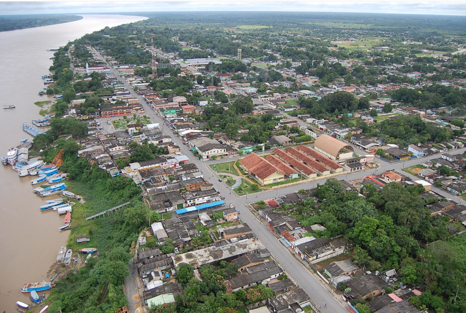
From the Air
Manicore (5.81S, 61.30W) sits at the confluence of the Manicore and Madeira rivers in southeastern Amazonas state. From altitude, look for the distinctive Y-shaped junction where the smaller Manicore River empties into the broad Madeira, with the town clustered on the Madeira's western bank about 3 kilometers downstream. Manicore Airport (SWMU) serves the town and provides a clear visual reference. The Madeira River is one of the Amazon's largest tributaries and serves as a reliable navigation corridor running roughly north-south. Expect tropical weather with frequent cloud buildup, particularly in the wet season from November to April. The Trans-Amazonian Highway (BR-230) passes through the southern reaches of the municipality.