Mariposa Grove: Where Lincoln Drew the Line
Abraham Lincoln was fighting a civil war when the Mariposa Grove petition reached his desk in June 1864. The Union Army had just suffered catastrophic losses at Cold Harbor. Sherman was grinding toward Atlanta. And yet Lincoln paused to sign an act ceding a grove of giant trees and a mountain valley to the state of California, to be held "for public use, resort, and recreation" - forever. No government anywhere had done this before. The idea that wilderness had value simply because it existed, that it deserved legal protection not for its timber or minerals but for its beauty, was born in part because of 427 giant sequoias standing on a Sierra Nevada hillside. Mariposa Grove did not just benefit from the conservation movement. It helped create it.
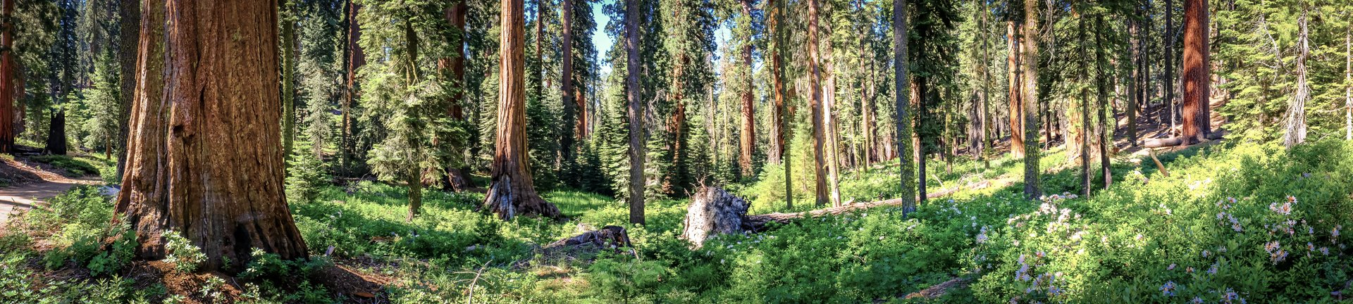
A Hunter's Rumor, a Guardian's Obsession
In 1856, Galen Clark heard a hunter mention three massive trees somewhere in the mountains above Wawona - trees like the ones recently discovered at Calaveras Grove, farther north. Clark spent a year searching. What he found in 1857 was not three trees but 427 mature giant sequoias, spread across upper and lower groves on the western Sierra slope. He named the place after Mariposa County, built a cabin among the trees, and appointed himself their unofficial guardian, guiding tourists and sleeping under trunks that had been growing since before the Roman Republic. Clark's devotion was total and lifelong. He became the first official guardian of the Yosemite Grant, serving until politics removed him, then was reappointed and served again until his death in 1910 at age 96. He is buried in the Yosemite Cemetery, as close to his trees as the grave could get.
The Trees You Could Drive Through
The grove's most famous spectacle was a feat of vandalism disguised as tourism. In 1881, the Yosemite Stage and Turnpike Company carved a tunnel through the Wawona Tree - seven feet wide, nine feet high, and 26 feet long, large enough for stagecoaches to pass through. The tunnel tree became the grove's defining image, reproduced on postcards and in newspapers worldwide. A second tunnel was cut through the California Tunnel Tree in 1895, this one sized for pedestrians. President Theodore Roosevelt was photographed driving through the Wawona tunnel in 1903, his carriage dwarfed by the opening. The Wawona Tree, weakened by the tunnel and by the weight of a heavy snow season, toppled in 1969. The California Tunnel Tree survives - the only living tunnel tree in the grove, and a reminder of an era when loving nature and mutilating it were considered the same thing.
The Century of Cars
When Yosemite lifted its automobile ban in 1913, everything about the park changed. Highway 41, completed in 1933, funneled visitors directly to the southern entrance near Mariposa Grove. The Yosemite National Park Company opened Camp in the Big Trees in 1919, offering cabins among the sequoias and eliminating the 18-mile round trip from the Wawona Hotel. The Big Trees Lodge followed in 1932, with 12 guest rooms and a photo darkroom. By 1969, traffic congestion had grown severe enough that officials introduced 50-passenger trams and banned private vehicles from the upper grove. Asphalt roads threaded between root systems. Gift shops operated in the shadow of 2,000-year-old trunks. The grove was being loved toward destruction - a pattern that would eventually force the most ambitious restoration project in the park's history.
Fire as Medicine
Giant sequoias need fire the way other species need rain. Their cones open in heat. Their seeds germinate only in mineral soil cleared by flame. Natural fires swept through Sierra Nevada groves every one to fifteen years for millennia, clearing undergrowth and cycling nutrients. After Anglo-American settlement, fire suppression became policy, and the consequences accumulated invisibly. Shade-tolerant white firs filled the understory, creating ladder fuels that could carry flames into the crowns of trees whose thick bark had evolved to survive ground fires. Controlled burns were reintroduced in 1968, and their value was proven dramatically during the 2022 Washburn Fire, when areas that had received prescribed burns survived while untreated zones burned intensely. But climate change is compounding the pressure. Between the 1930s and 1990s, large-diameter trees in Yosemite declined by 24 percent due to water stress, and the 2012-2017 drought killed several sequoias outright.
The Grove Restored
On July 6, 2015 - one year after the 150th anniversary groundbreaking of the Yosemite Grant - Mariposa Grove closed for what would become a three-year restoration project, the largest in the park's history. Workers removed asphalt roads, restored natural water flows that pavement had diverted from root systems, realigned trails, eliminated the tram service and gift shops, and built a welcome plaza near the south entrance with free shuttle service. When the grove reopened on June 15, 2018, private cars were no longer allowed. Visitors ride a shuttle two miles to the trailhead and walk among the trees on foot. The experience is quieter, slower, and closer to what Galen Clark knew in 1857 - minus the cabin, plus a million annual visitors who arrive by bus instead of stagecoach. The grove still holds two of the 30 largest giant sequoias on Earth. It still attracts the curious, the reverent, and the simply overwhelmed. Lincoln's gamble - that wilderness protected is wilderness preserved - continues to pay off, 160 years and counting.
From the Air
Located at 37.51°N, 119.60°W in the southernmost section of Yosemite National Park, on the western slope of the Sierra Nevada. From altitude, the grove appears as an unusually dense cluster of massive conifers distinct from the surrounding mixed-conifer forest. Highway 41 (Wawona Road) passes near the south entrance. Nearest airport: Mariposa-Yosemite Airport (MPI), approximately 30 nm northwest. Fresno Yosemite International (KFAT) lies about 50 nm south-southwest. Recommended viewing altitude: 5,000-8,000 ft AGL for grove context. Terrain is mountainous with ridgelines rising to 7,000+ ft; expect afternoon convective turbulence in summer.