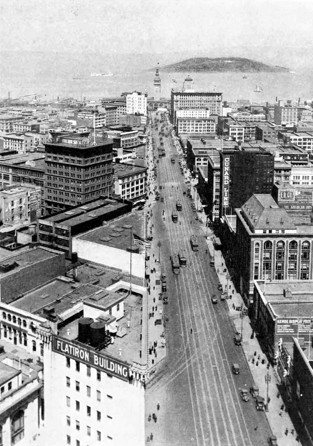
Market Street (San Francisco)
In 1847, a 26-year-old Irish civil engineer named Jasper O'Farrell laid out a street 120 feet wide, aimed like an arrow at the twin peaks the Spanish had called Los Pechos de la Chola, the Breasts of the Maiden. Property owners thought the street was absurdly, offensively wide. They held an indignation meeting that turned into a mob, and O'Farrell fled on horseback to North Beach, caught a boat to Sausalito, and galloped on relay horses to his retreat in Sonoma. He found it discreet to remain in the country for some time. The street he nearly died for is Market Street, and it has been the most important three miles in San Francisco ever since.
The Seam Between Two Grids
Market Street is not just a road. It is the boundary between two street grids that do not agree with each other. Streets to the northwest follow a grid nine degrees off from the cardinal directions, laid out by Jean Jacques Vioget in 1839 for the Mexican trading post of Yerba Buena. Streets to the southeast run parallel or perpendicular to Market itself, drawn on a larger block pattern aligned with Mission Street. O'Farrell designed Market to stitch these competing grids together, and the result is a diagonal slash through the city that has shaped San Francisco's geography, commerce, and class structure ever since. South of Market was historically working class and industrial. North of Market was where the money lived. The street between them carried all the traffic in both directions.
Sand Dunes, Steam Shovels, and Four Tracks
When O'Farrell drew his line, Market Street existed only on paper. A sixty-foot sand dune stood where the Palace Hotel would later rise. A hundred yards further west, a second dune reached ninety feet. David Hewes, nicknamed Steam Paddy for the steam shovel he used, spent years leveling them, using the sand to fill Yerba Buena Cove and build a railroad bed. By 1918, the street carried four parallel rail tracks, two for the Municipal Railway and two for the United Railroads of San Francisco, an arrangement known as the roar of the four. Horse-drawn streetcars gave way to cable cars, then electric streetcars, then trolleybuses. Today, Muni buses, heritage streetcars on the F Market line, and underground Muni Metro and BART trains all share the corridor, making Market Street one of the most transit-dense thoroughfares in America.
Destruction and the Path of Gold
On April 18, 1906, the earthquake and fire left Market Street in ruins. Buildings were dynamited to stop the flames. The burned area stretched from Dolores east to the waterfront. Within days, business owners announced plans to rebuild. Track repairs were underway by April 22. Out of the reconstruction came the Path of Gold streetlamps, designed by Willis Polk in 1908 with sculptural tops by Leo Lentelli and bases by Arthur Putnam featuring covered wagons, mountain lions, and alternating prospectors and Native Americans. The ornamental poles were the city's price for permitting the overhead trolley wires that businesses despised. They still line Market Street today, gold-topped sentinels marking a road that has been destroyed and rebuilt so many times that reinvention is part of its character.
The Parade Route
Market Street has always been where San Francisco performs itself. The Panama-Pacific International Exposition paraded down it in 1915. The Preparedness Day Bombing struck it in 1916. Influenza-masked revelers marched on the first Armistice Day. The 1934 general strike paralyzed it. After World War II, Anthony Eden and Vyacheslav Molotov waved from open cars during the United Nations conferences. On Christmas Eve 1910, Luisa Tetrazzini sang to a crowd estimated at 250,000 after being barred from a theater stage. On New Year's Eve 1999, 1.2 million people packed the street for the millennium celebration. The San Francisco Pride parade fills it every June. Victory parades for the Giants' World Series titles took it over in 2010, 2012, and 2014. In January 2020, private cars were banned from most of Market Street, completing a transformation from the widest road in a frontier town to a transit and pedestrian corridor. O'Farrell, who nearly lost his life for making the street too generous, would be pleased.
From the Air
Market Street runs diagonally from 37.79°N, 122.39°W (The Embarcadero/Ferry Building) southwest to Twin Peaks at 37.75°N, 122.45°W. The street is clearly visible from altitude as a prominent diagonal line cutting through San Francisco's grid. Nearest airports: SFO (KSFO, 10 nm south), Oakland (KOAK, 10 nm east). The Ferry Building clock tower marks the street's northeastern terminus.