Masaya Volcano
The Spanish friars who first peered into the Santiago crater of Masaya saw the devil looking back. They planted a cross at the rim — La Cruz de Bobadilla — to ward off what they believed was a gateway to Hell. Five centuries later, visitors still drive to the crater's edge after dark to watch the orange glow of lava pulsing in the pit below. Masaya is not a single volcano but a nested complex of calderas and craters, the product of 2,500 years of eruptions that have built, collapsed, and rebuilt the landscape south of Managua. Its Nawat name, Popogatepe, predates the Spanish by centuries, and its reputation for menace has never dimmed.
A Caldera Within a Caldera
The structure of Masaya is like a set of Russian nesting dolls made of basalt. The outermost layer is the Las Sierras shield volcano and its caldera. Within that sits Masaya caldera, formed 2,500 years ago by a massive basaltic ignimbrite eruption that expelled eight cubic kilometers of material. Inside this caldera, new eruptions along a semi-circular set of vents built the Masaya and Nindiri cones, which in turn host four pit craters: Masaya, Santiago, Nindiri, and San Pedro. Santiago is the active one. It continuously vents sulfur dioxide in quantities large enough to generate acid rain downwind, and volcanologists use these gas emissions as a window into the volcano's behavior. The caldera floor is covered in rough, poorly vegetated aa lava, evidence that the surface has been resurfaced within the last thousand years.
Lava Lakes and Quiet Centuries
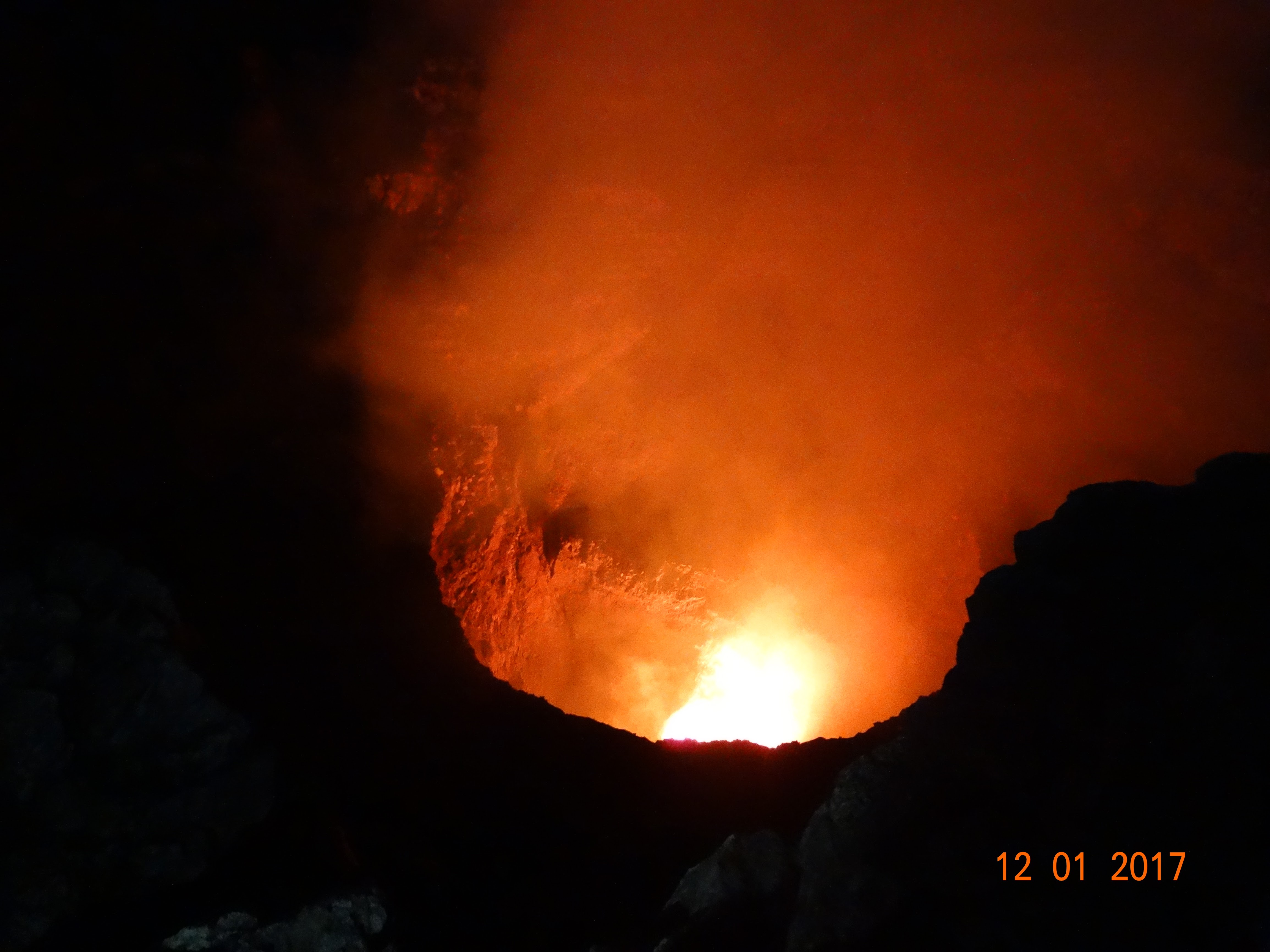
For all its fearsome reputation, Masaya has been relatively restrained in recent centuries. Only two lava flows have reached the surface since the 1500s. The first, in 1670, overflowed from Nindiri crater, which at the time contained a lava lake roughly one kilometer wide. The second, in 1772, issued from a fissure on the flank of the Masaya cone. Since then, lava has appeared only inside the Santiago pit crater and possibly within Nindiri in 1852. A lake occupies the far eastern end of the caldera, a calm counterpoint to the sulfurous venting at Santiago. The recent activity has been dominated by persistent degassing from an occasionally lava-filled pit, punctuated by discrete explosive events over the past 50 years. Masaya is one of 18 volcanic centers along the Nicaraguan portion of the Central American Volcanic Belt, formed by the subduction of the Cocos Plate beneath the Caribbean Plate along the Mesoamerican Trench.
Nicaragua's First National Park
In 1979, the same year the Sandinista Revolution transformed the country, Masaya became Nicaragua's first national park. Parque Nacional Volcan Masaya covers 54 square kilometers and encompasses two volcanoes and five craters, with elevations ranging from 100 to 630 meters above sea level. A paved road leads directly to the rim of Santiago crater — one of the few places on Earth where you can drive to the edge of an active volcanic vent. Inside the park, a lava tube formed by ancient flows shelters colonies of bats. At night, the glow from Santiago draws visitors who stand at the guardrail and watch the crater breathe, smoke rising against the stars. The park lies just 20 kilometers south of Managua, making it one of the most accessible active volcanic sites anywhere.
Walking the Wire
On March 4, 2020, the tightrope artist Nik Wallenda walked across a steel cable suspended over the Masaya caldera, with sulfurous gases rising around him and lava glowing below. The stunt, broadcast live on television, captured something essential about this volcano: it exists at the intersection of genuine danger and irresistible spectacle. The sulfur dioxide plume that Wallenda walked through is the same one that volcanologists study for signs of changing magma behavior, the same one that generates acid rain affecting downwind communities, the same one that the Spanish friars took for the breath of Satan. Masaya has always been a place where people cannot resist getting close to something they probably should not.
The Restless Neighbor
Twenty kilometers is not a comfortable distance between a capital city and an active volcanic complex. Managua, with its population of over a million, sits within range of Masaya's ash clouds, gas plumes, and the seismic tremors that accompany volcanic activity. The volcano is monitored by INETER, Nicaragua's territorial studies institute, which tracks seismic signatures, gas output, and deformation. From the air, the caldera is unmistakable: a dark, roughly circular depression broken by craters and lava fields, with the white plume from Santiago crater drifting southeast on the prevailing wind. The contrast between the barren caldera floor and the green farmland surrounding it marks the boundary between geological violence and everyday life in western Nicaragua.
From the Air
Masaya Volcano sits at 11.983°N, 86.162°W, approximately 20 km south of Managua. From 5,000–8,000 feet AGL, the caldera complex is clearly visible as a dark, barren depression against green agricultural land. The active Santiago crater often produces a visible sulfur dioxide plume drifting southeast. Augusto C. Sandino International Airport (MNMG) in Managua is the nearest major airfield. Beware of volcanic gas emissions at lower altitudes and check NOTAMs for volcanic activity. The caldera floor, lava fields, and crater lakes are all distinguishable from altitude.