Maseru
If you have ever bought a t-shirt from Old Navy or Gap, there is a reasonable chance it was stitched together two kilometers south of Maseru's city center, in the industrial district of Thetsane. The factories there churn out garments for American chain stores, their sewing machines humming in a rhythm that contrasts sharply with the slow pace of life everywhere else in Lesotho. It is an odd introduction to a capital city, but Maseru has always been a place of contrasts: African and European, mountain and plain, ancient kingdom and modern nation. The name means 'place of the red sandstones' in Sesotho, and the reddish earth of the Caledon River valley gives the city its literal foundation.
A Kingdom's Refuge
Lesotho exists because of a mountain. In the 1820s, during the upheaval known as the Difaqane, a chief named Moshoeshoe I led his followers to the flat-topped mountain fortress of Thaba Bosiu, about 30 kilometers east of modern Maseru. From that summit, he repelled attackers, united disparate clans, and built the Basotho nation. When Boer settlers from the Orange Free State began encroaching on Basotho lands in the 1850s and 1860s, Moshoeshoe made a pragmatic decision: he requested British protection. In 1868, Basutoland became a British protectorate, and in 1869, Maseru was established as a police camp on the bank of the Caledon River, just inside the border with South Africa. That border location was strategic. Maseru sits within sight of South Africa, separated from the Free State town of Ladybrand by little more than a river crossing. The Mountain Kingdom's capital is also its front door.
The Mokorotlo and the Factories
Maseru's skyline is modest, but one building stands out. The Mokorotlo, shaped like the traditional Basotho straw hat that appears on the national flag, is a cultural center built in modern architectural style. Inside, it functions as a museum of Basotho traditions, displaying the crafts, textiles, and oral histories of a people whose identity was forged in highland isolation. A few blocks away on Kingsway, the Basotho Hat craft shop sells handmade copper and ceramic jewelry, dresses, and the wire push toys that are a signature Lesotho craft, all housed in a building whose architecture echoes the hat's conical form. The Lesotho National Museum holds traditional sculptures and historical artifacts. But Maseru is less a destination than a staging ground. Most travelers pass through on their way to pony trekking in the highlands at Semonkong or Malealea, or to the alpine passes that climb above 3,000 meters into some of the most dramatic mountain scenery in southern Africa.
Cave Dwellers and Rocky Hills
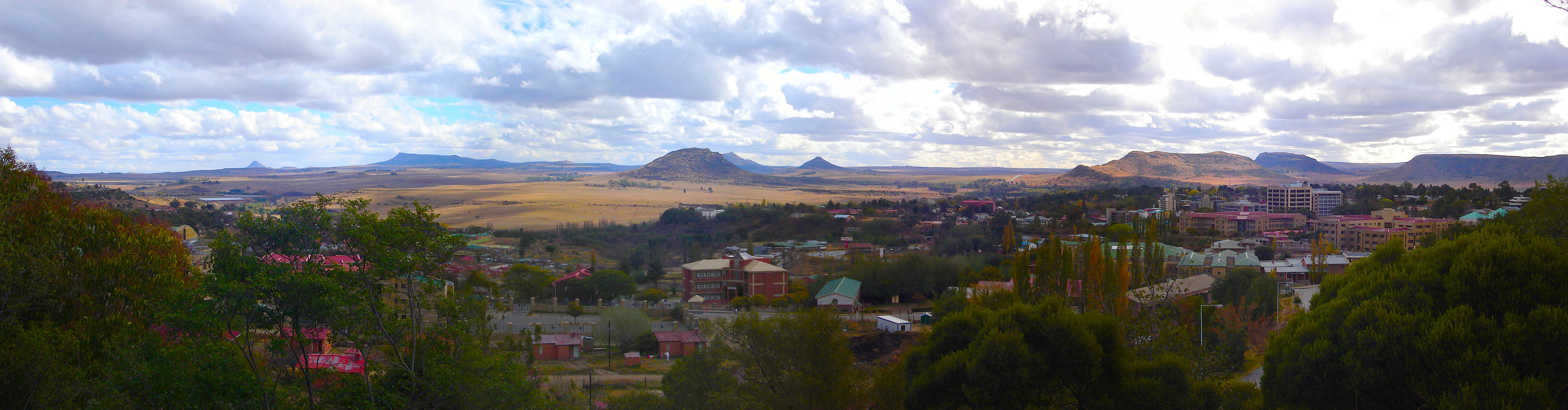
The Kome Cave Dwellings, accessible from Maseru by a rough road that demands a four-wheel-drive vehicle, offer a glimpse into Lesotho's pre-colonial history. Built in the early 19th century by Chief Teleka of the Basia clan, the dwellings were carved into a sandstone overhang as a hideout during the droughts and conflicts of the late 18th century. People still live in some of them. Back in Maseru, the rocky hill behind the Avani hotel rewards a 30-minute climb with panoramic views of the city and the Caledon River valley. The Chinese-built parliament building sits partway up the slope, a product of Lesotho's diplomatic support for the One China policy. From the summit at sunset, the landscape reveals why Lesotho earned its nickname: over 80 percent of the country lies above 1,800 meters, making it the only independent nation in the world where every point of land exceeds 1,000 meters in elevation. The mountains that sheltered Moshoeshoe's people still define the country's character.
Border Town Rhythms
Maseru lives in South Africa's shadow, and it knows it. The nearest cinema is across the border in Bloemfontein, 137 kilometers away. Many residents cross into Ladybrand when they want what locals call 'Western-ness,' a word that encompasses shopping malls, fast food chains, and the general bustle of a South African town. But Maseru has its own rhythms. On Kingsway, lunchtime brings the White Box Food vendors, who serve chicken, pork, rice, and papa from portable stalls to a crowd of office workers for 12 to 15 maloti a box. The Peace Restaurant, tucked behind a Chinese grocery shop on Moeshoeshoe Road, offers authentic Chinese food with karaoke on weekend nights. The Good Times Cafe, perched above a Vodacom shop, is the city's only real nightspot, quiet on weeknights but electric after payday at month's end, when live music draws Lesotho's young professionals. Moeshoeshoe Day in early March fills the streets with colorful processions. In a capital that serves primarily as a gateway, these small rituals of daily life are what make Maseru more than a place to pass through.
From the Air
Coordinates: 29.31S, 27.48E. Maseru sits on the western border of Lesotho, along the Caledon River that forms the boundary with South Africa's Free State Province. The city is at approximately 1,600 m (5,250 ft) elevation, with the Lesotho highlands rising dramatically to the east. Moshoeshoe I International Airport (FXMM) is 18 km south of the city center. The Maseru Bridge border crossing into South Africa is clearly visible from the air. To the east, the terrain rises rapidly into the Maluti Mountains, with peaks exceeding 3,000 m. Thaba Bosiu, the historic flat-topped mountain fortress, is visible approximately 30 km to the east. Bloemfontein (FABL) is 137 km to the west. Expect turbulence near the mountain escarpment. Recommended viewing altitude: 5,000-8,000 ft AGL.