Matiu / Somes Island Lighthouse
Three colours of light reach across Wellington Harbour from the southern tip of Matiu / Somes Island: white down the centre of the navigation channel, ruby to one side, green to the other. Stray from the white beam and you know immediately that your vessel has drifted. This is a sector light, one of the simplest and most elegant solutions in maritime navigation, and it has been operating here in one form or another since 1866 - making the Matiu / Somes Island lighthouse the first inner harbour lighthouse in all of New Zealand.
Eight Lights for a Young Colony
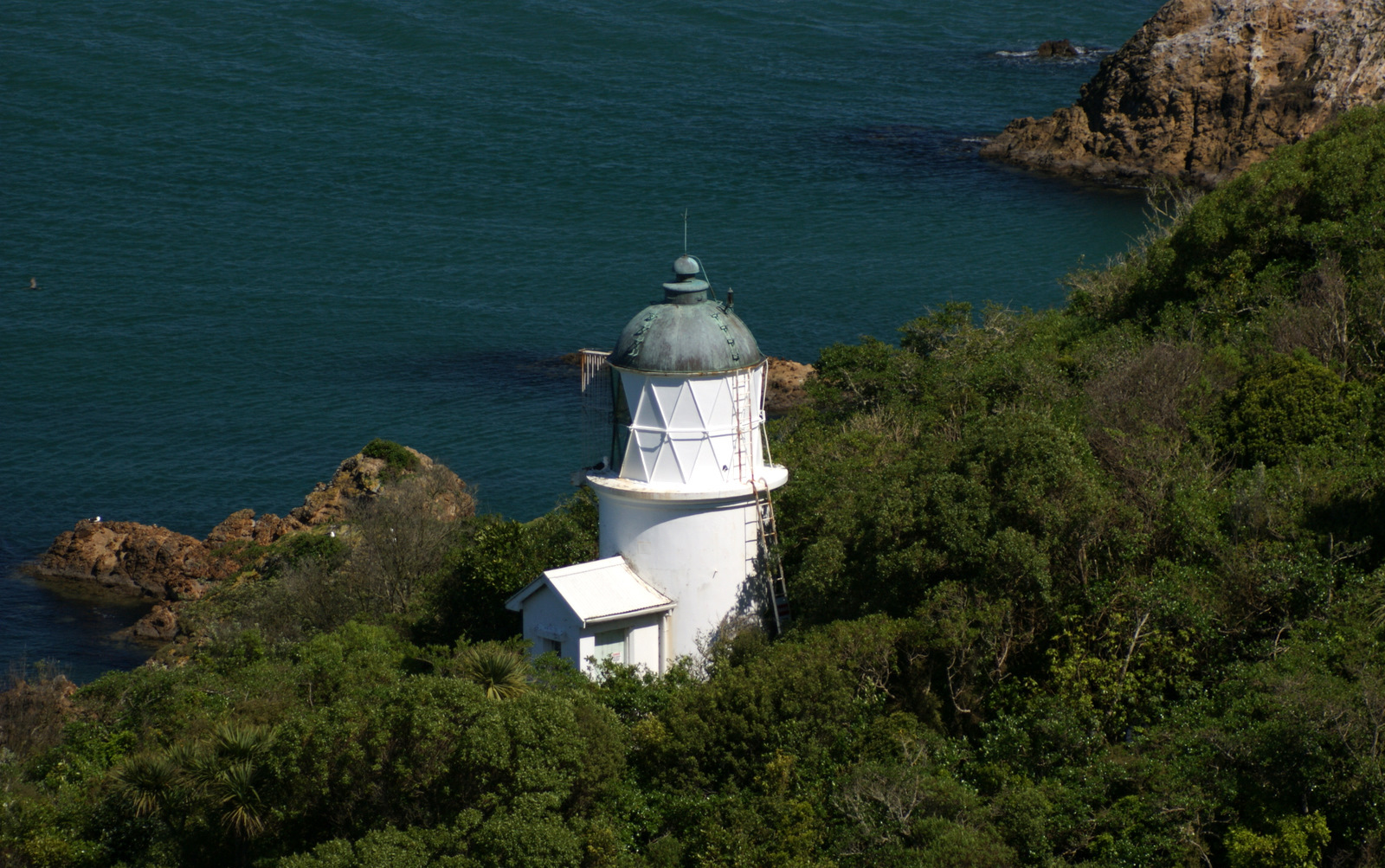
When the first lighthouse was established on Somes Island in 1866, New Zealand had only eight lighthouses in the entire country. A signal station had been operating on the island since around 1840, but navigating Wellington Harbour at night remained dangerous without a proper light to mark the channel. The lighthouse that went up was modest: an octagonal cast-iron tower just ten feet high, bolted to a brick foundation. Inside sat a fourth-order Fresnel lens with a 270-degree illumination angle. Ruby and green glass screens flanked a white beam aimed straight down the harbour channel. The lamp burned colza oil - a rapeseed derivative common in nineteenth-century lighthouses - until a conversion to kerosene in 1878. For three decades, this small light was the sole guide for vessels entering one of the most important harbours in the southern hemisphere.
A Light Found Wanting
By 1895, the complaints had grown loud enough to reach the Marine Department. Ship masters reported that the Somes Island light was inadequate - too dim, too small for a harbour handling increasing traffic. The department decided to upgrade from a fourth-order to a second-order Fresnel lens, a significant jump in light-gathering power. A replacement apparatus was ordered in 1898, and the new lighthouse was commissioned on 21 February 1900. The old lens found a second life at Tuhawaiki Point in Timaru, where it was reinstalled rather than scrapped. The new light served with human keepers for nearly a quarter century before being automated on 1 April 1924. After 1945, the conversion to electricity retired the last of the oil and kerosene that had fueled the light through two world wars. The lamp that once required a keeper's constant attention now ran itself.
Island and Sanctuary
Matiu / Somes Island sits in the middle of Wellington Harbour like a green sentinel. The island's history runs far deeper than its lighthouse: it served as a quarantine station, an internment camp during both world wars, and a military installation. Today it is a scientific reserve managed by the Department of Conservation, home to native species including tuatara, weta, and seabirds that have been reintroduced as part of predator-free restoration efforts. The original lighthouse reserve has been folded into this protected landscape. Visitors can reach the island by ferry from Wellington's waterfront and walk the trails that wind past the lighthouse, the old quarantine buildings, and regenerating native bush. The lighthouse itself, now operated and maintained by the Greater Wellington Regional Council, continues to function as an active navigation aid - still casting its three-coloured beam across the harbour, still sorting the safe passage from the dangerous.
A Beam That Persists
What makes the Matiu / Somes Island lighthouse remarkable is not its size or its drama - it is neither tall nor particularly photogenic compared to New Zealand's coastal lights. Its significance lies in persistence. The same basic function it served in 1866, marking the safe channel through Wellington Harbour with coloured light, it serves today. The technology has changed from colza oil to kerosene to electricity, from a fourth-order lens to a second-order, from human keeper to automation. But the principle remains identical: a fixed point of light that tells navigators where they are relative to where they need to be. In a harbour ringed by hills and exposed to the fierce northerlies and southerlies that funnel through Cook Strait, that simple service has been saving lives for more than a century and a half.
From the Air
Located at 41.26S, 174.86E on the southern end of Matiu / Somes Island, sitting prominently in the middle of Wellington Harbour. The island is clearly visible from any altitude as a dark green landmass roughly 25 hectares in size within the enclosed waters of the harbour. The lighthouse sits on the island's southern tip, oriented to guide vessels approaching from the harbour entrance to the south. Nearest airport: Wellington International (NZWN), approximately 5 km to the southeast on the Miramar peninsula. The harbour entrance, between Point Dorset and Pencarrow Head, is visible to the south. Viewing altitude: 2,000-5,000 ft for excellent perspective on the island's position within the harbour channel.