Mayombe
In 1950, the forests of Mayombe covered an estimated 500,000 hectares. By the time anyone measured again, that figure had dropped to 80,000. The loss is extraordinary, but so is what remains. Mayombe -- sometimes spelled Mayumbe -- is a chain of low mountains running along the western coast of Central Africa, from the mouth of the Congo River northward to the Kouilou-Niari River. The range crosses four countries: the Democratic Republic of the Congo, Angola's Cabinda Province, the Republic of the Congo, and Gabon. It is not high -- Mount Foungouti, the tallest peak, reaches only 930 meters -- but the terrain is steep, the rivers swift, and the forest ancient enough to have attracted archaeologists studying Iron Age metallurgy dating back over 2,000 years.
Where Four Countries Share a Forest
Mayombe sits on the right bank of the Congo River -- the world's second-largest by discharge -- just before it empties into the Atlantic at Banana. The range extends from the city of Boma northward through the Angolan enclave of Cabinda and into the Republic of the Congo and Gabon. Rivers cut through the hills with swift currents: the Shiloango and its tributaries, the Lukula and the Lubuzi, drain the region's steep terrain. The peaks are modest but numerous. Below Foungouti's 930 meters, Mount Bamba reaches 810, the Kinoumbou Mountains 784, and Ngouedi 780. In the Democratic Republic of the Congo, Mayombe encompasses the towns of Lukula, Seke Banza, Kangu, and Tshela in the northwestern province of Kongo Central. Political borders divide the forest, but the forest itself does not recognize them -- the same canopy, the same rainfall, the same species extend across all four nations.
Humidity, Limba, and the Vanishing Canopy
South of the equator but within the equatorial zone, Mayombe has an oceanic-influenced climate that divides into two seasons. The long dry season from June to September is milder here than in the rest of the Lower Congo -- altitude and forest cover moderate the heat, with temperatures ranging from 17 to 22 degrees Celsius and dropping to 8 at night. The rainy season, October through May, brings temperatures of 28 to 33 degrees and humidity approaching 100 percent. Trade winds condense against the coastal range's cliffs, adding to the perpetual sense of dampness. The flora ranges from dense forest to savanna dotted with forest trees. Among the most valuable species is the Limba, a tall hardwood that accounts for over 40 percent of the remaining forest cover. Palm trees are abundant and form one of the region's most important resources for local communities. But the numbers tell a stark story: what was once half a million hectares of forest has shrunk to roughly 80,000, a decline driven by logging, agriculture, and the pressures of growing populations in four countries simultaneously.
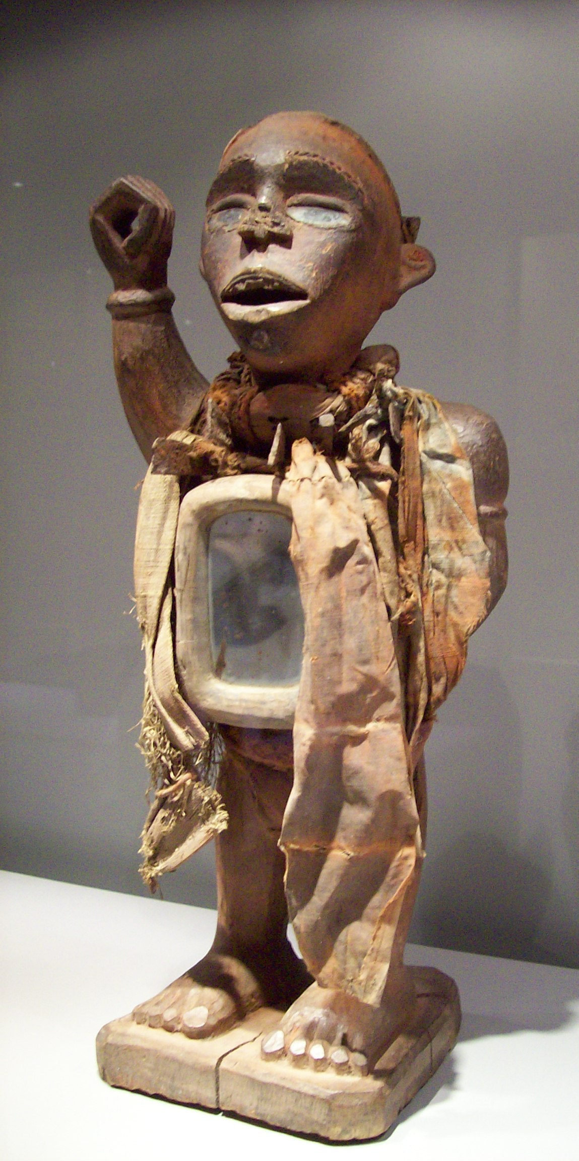
The Yombe and the Art of Mayombe
The dominant ethnic group in the Mayombe region is the Yombe, a subset of the Kongo people. Their artistic traditions -- particularly carved figures with mirrors, power objects, and elaborate ceremonial pieces -- have drawn the attention of ethnographers and collectors since the late nineteenth century. Leo Bittremieux published studies of Mayombe folk art in 1924 and documented the secret society of the Bakhimba in 1936. Archaeological work has revealed Iron Age smelting sites dating to 2,110 years before present, and a more recent iron-working site at Ganda-Kimpesse dated to around 300 years ago shows that metalworking persisted in the region across two millennia. The Yombe's cultural continuity in these mountains is remarkable, sustained through periods of colonial extraction, political upheaval, and environmental destruction that transformed the landscape around them.
A Railway Dismantled, a Forest Divided
The Mayombe Railway once linked Boma to Tshela in the DRC, with a planned extension to the Republic of the Congo that was never completed. Under President Mobutu Sese Seko, the railway was dismantled entirely -- its tracks pulled up and reused near Gbadolite, 1,200 kilometers to the northeast, where Mobutu built an extravagant palace complex in his home village. The decision captured something about the Mobutu era: infrastructure serving actual populations sacrificed for personal vanity projects. On the Congolese side of the mountains, the Congo-Ocean Railway -- built during the colonial period at enormous human cost -- still serves the Mayombe corridor, connecting Pointe-Noire on the coast to Brazzaville. The contrast between the two railway stories mirrors the region's broader challenge: shared geography, shared ecology, shared peoples, but fragmented governance and competing national priorities that make coordinated conservation or development nearly impossible.
From the Air
Located at approximately 4.25S, 13.50E, the Mayombe mountain range extends along the Atlantic coast of Central Africa across parts of the DRC, Angola (Cabinda), Republic of the Congo, and Gabon. From altitude, look for the low but distinct mountain ridge running roughly north-south parallel to the coast, with dense forest cover contrasting against surrounding savanna. The Congo River's mouth is visible to the south. Mount Foungouti (930 m) is the highest point. Nearest airports: Boma Airport in the DRC; Pointe-Noire Airport (FCPP) in the Republic of the Congo. The Congo-Ocean Railway is visible as a linear feature cutting through the forested terrain.