Meili Snow Mountains
No one has ever stood on top of Kawagarbo. At 6,740 meters, the highest peak of the Meili Snow Mountains is not the tallest unclimbed mountain in the world, but it may be the most fiercely defended -- by weather, by terrain, and by the people who consider it sacred. In January 1991, a joint Sino-Japanese expedition reached 6,470 meters before an avalanche buried all 17 members. Their bodies were not recovered for years. For the Tibetan Buddhists who live in the valleys below, the disaster confirmed what they had always known: the mountain does not welcome those who try to conquer it. After weighing the local cultural perspective and the mountain's lethal conditions, the government of Deqin County banned all climbing on Meili Snow Mountains. The peaks remain inviolate.
The Mountains of Herbs
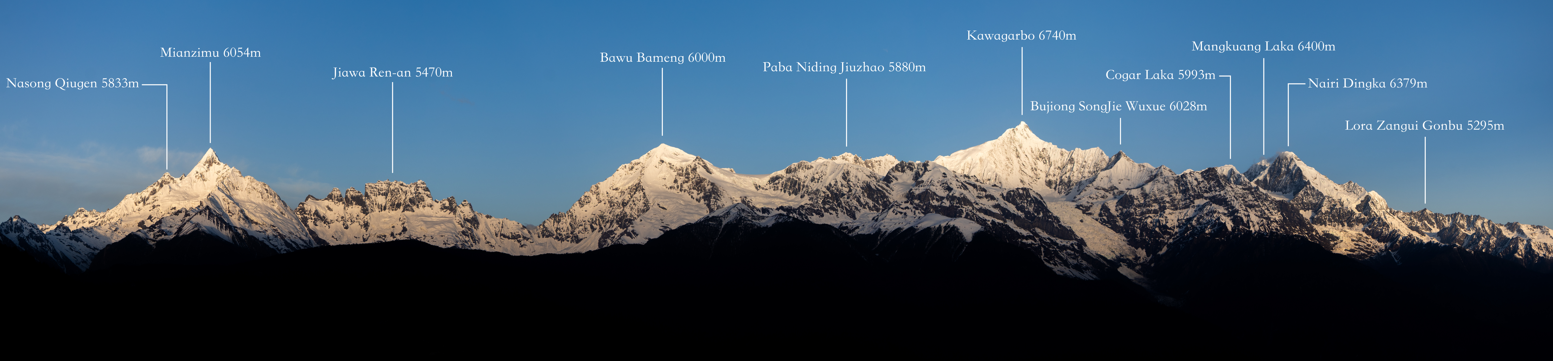
In Tibetan, "Meili" -- more accurately rendered as "Mainri" -- means mountains of herbs, a name earned by the medicinal plants that grow on the lower slopes. The range rises in northwestern Yunnan Province near the border with Tibet, bounded by the Nujiang (Salween) to the west and the Lancang (Mekong) to the east. It forms a subrange of the Nu Mountains within the larger Hengduan group, a chain of parallel ranges where Asia's great rivers have carved some of the deepest gorges on Earth. The crest exceeds 6,000 meters across multiple peaks, while the river valleys on either side sit between 1,500 and 1,900 meters -- a vertical relief of over four kilometers that makes Meili one of the most dramatically prominent mountain ranges anywhere. Kawagarbo dominates the skyline, flanked by Mianzimu at 6,054 meters, known locally as the God Daughter Peak, and a constellation of lesser summits whose Tibetan names -- Five Buddha Peak, Son Peak -- reflect the mythology draped across this landscape.
The Mountain That Refuses
Mountaineers have tried and failed since at least 1987, when the Joetsu Alpine Club of Japan abandoned their attempt on Kawagarbo at 5,100 meters after continuous avalanches on the Mingyong Glacier route. The 1990-91 expedition was the most ambitious and the most tragic. The joint Chinese-Japanese team chose the Mingyong Glacier route and climbed to within 270 meters of the summit before the mountain killed them all. The avalanche that struck their high camp on January 3, 1991, was so massive that some remains did not emerge from the glacier until years later. For the Tibetan communities of Deqin, the deaths were not a mountaineering accident but a consequence of blasphemy. Ascending Kawagarbo violates the sacredness that Tibetan Buddhists ascribe to the peak -- it is one of the most important pilgrimage mountains in the Tibetan world, and pilgrims circumambulate it rather than climb it. The climbing ban, enacted by local government, stands as a rare instance where Indigenous spiritual values formally overrode the ambitions of international alpinism.
Thirteen Peaks, Thirteen Stories
Kawagarbo is the monarch, but the Meili range contains at least thirteen named peaks above 5,000 meters, each carrying its own identity in Tibetan tradition. Mianzimu, the Queen Peak, rises to 6,054 meters just south of Kawagarbo. Zhandui Wuxue reaches 6,400 meters. Nairi Dingka and Mabing Zhala Wangdui both exceed 6,300 meters. None have been climbed. The lower peak Lora Zangui Gonbu, at 5,229 meters, is considered the geographic main peak of the range, though Kawagarbo towers above it by more than 1,500 meters. Glaciers feed down from these summits into valleys where the microclimate shifts dramatically with elevation: subtropical forest in the river bottoms, alpine meadow on the shoulders, permanent ice above. The Mingyong Glacier, one of the lowest-latitude glaciers in the Northern Hemisphere, descends to around 2,700 meters -- close enough that tourists from the nearby town of Deqin can approach it on foot.
Vanishing Ice, Shifting Rains
The monsoon drives Meili's weather, delivering roughly 67 percent of annual precipitation between June and September. But the pattern is changing. Observations since 1990 show spring precipitation declining by 10 percent across the range. Temperatures are rising. The relationship between rainfall and altitude creates an unusual asymmetry: on the west side, precipitation decreases at lower elevations during monsoon season, while on the east side below 3,700 meters, rainfall increases dramatically. The practical consequence is that glacial water resources are shrinking. Meili's glaciers are retreating, their meltwater feeding rivers that communities in the valleys depend on for irrigation and drinking water. The environmental stakes are high for a range that sits at the intersection of the Tibetan Plateau and the subtropics, supporting a biome of exceptional diversity. Protecting this water tower has become, in the language of the climate scientists studying the range, "decisive to its biome system" -- a dry way of saying that if the glaciers vanish, so does much of what makes these mountains extraordinary.
From the Air
Located at 28.44N, 98.68E in northwestern Yunnan Province, China. The Meili Snow Mountains are unmistakable from altitude -- a wall of glaciated peaks running north-south between two deep river gorges (Nujiang/Salween to the west, Lancang/Mekong to the east). Kawagarbo at 6,740 meters is the dominant summit. The range sits within the Three Parallel Rivers UNESCO World Heritage area. Nearest airport is Shangri-La Diqing Airport (ZPDQ), approximately 150 km to the southeast. Expect severe mountain weather, strong winds, and rapid cloud formation especially during monsoon season (June-September). Terrain rises from valley floors at 1,500 meters to peaks above 6,700 meters within a few horizontal kilometers.