Mercer Island
Mercer Island occupies the most convenient piece of real estate in the Seattle region - an island in Lake Washington directly between Seattle and Bellevue, straddled by Interstate 90. For decades it was called 'East Seattle,' a humble name for what has become one of the most expensive zip codes in Washington. The island's 25,000 residents enjoy water views in every direction, parks that would make larger cities envious, and a commute that drops them into either downtown Seattle or the Eastside tech campuses within minutes. There are no hotels, no significant commercial areas, almost nothing to draw visitors. That's rather the point.
The I-90 Corridor
Interstate 90 doesn't just pass by Mercer Island - it cuts straight through, connecting the floating bridges that span Lake Washington on either side. The Homer M. Hadley Memorial Bridge links to Seattle; the Lacey V. Murrow Memorial Bridge (rebuilt after the original sank in 1990) continues to Bellevue. These are among the longest floating bridges in the world, concrete pontoons riding the lake surface because the water is too deep for conventional pilings. For Mercer Island residents, the bridges represent both connection and isolation - easy access to everywhere, yet surrounded by water that keeps the outside world at arm's length.
Island Geometry
The island is roughly five miles long and two miles wide, its topography a series of gentle hills that provide the water views everyone came for. Island Crest Way runs down the spine; scenic Mercer Way wraps around the perimeter, offering drivers (and cyclists, when they're brave) a loop past waterfront homes that range from merely expensive to genuinely palatial. Parks dot the shoreline - small beach accesses, viewpoints, the occasional community gathering space. The north end holds the commercial district such as it is; the south end is pure residential, streets winding through forests that screen houses from each other and preserve the illusion of privacy.
Lid Park Paradox
When I-90 was rebuilt in the 1980s and 1990s, the state capped part of the freeway with a lid - a concrete cover that supports parkland while traffic rumbles beneath. Lid Park represents the peculiar bargain Mercer Island struck with progress: accept the highway through your heart, but demand something in return. The western edge of the park offers views across the lake to Seattle's skyline, the very view the freeway's construction opened up by clearing structures. It's an odd kind of beauty, built atop infrastructure, the sound of trucks muffled by the same concrete that creates the park. Mercer Island has always been about managing contradictions.
Bedroom Community Refined
Mercer Island has no pretensions to being anything other than what it is: a wealthy residential community with good schools, low crime, and easy access to jobs elsewhere. The few restaurants serve the local market. The parks exist for residents. The absence of hotels reflects a community that doesn't particularly want visitors - or need them. It's suburban aspiration purified to its essence, stripped of the commercial sprawl that defines most American suburbs. The light rail extension, opening in 2026, will connect Mercer Island to Seattle and Bellevue by train, potentially changing the character that decades of bridge-only access preserved. Change comes slowly to islands, even ones bisected by freeways.
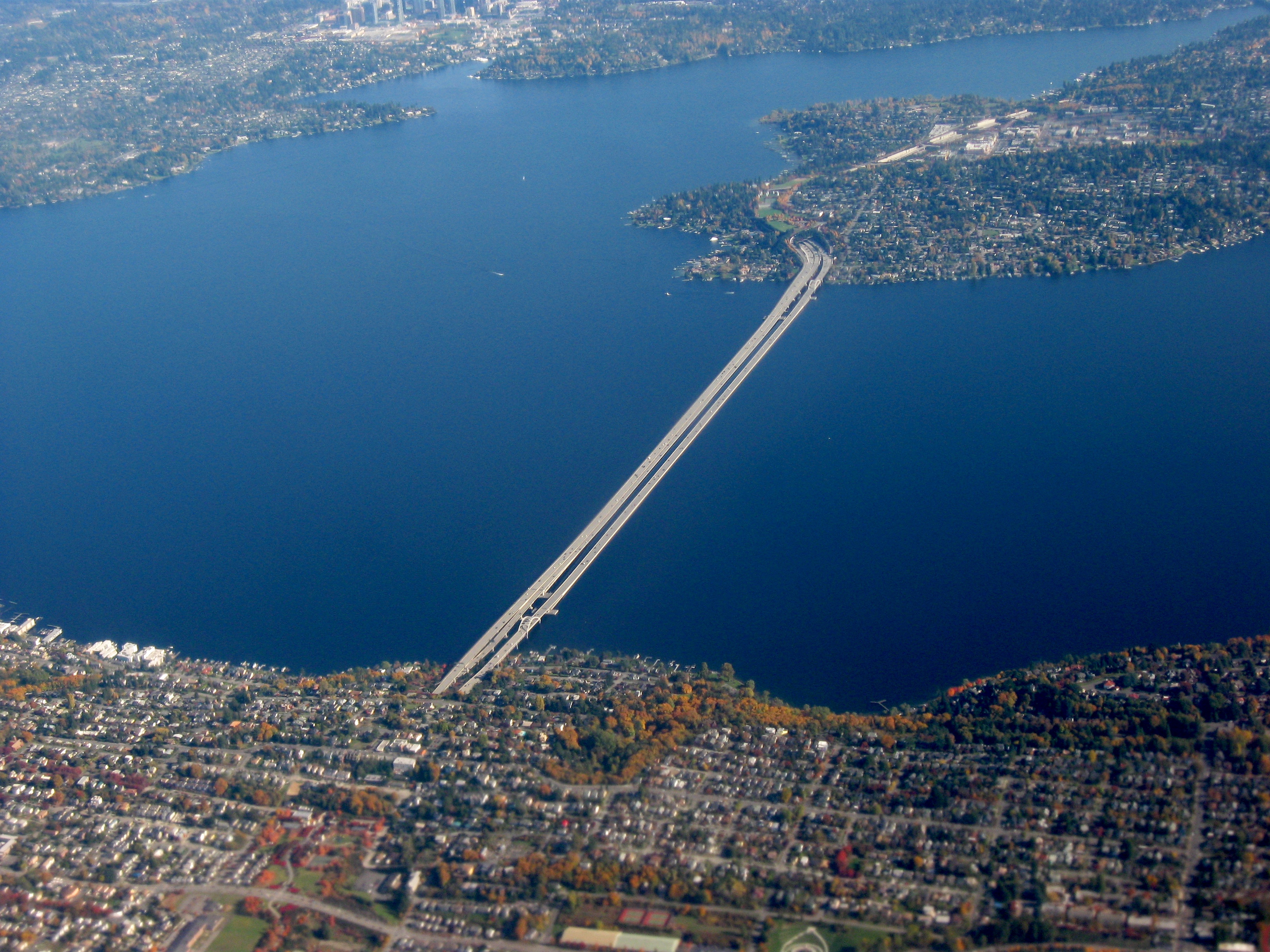
From the Air
Located at 47.57°N, 122.23°W in Lake Washington between Seattle and Bellevue. The island is unmistakable from altitude - a 5-mile-long landmass split by the I-90 floating bridges visible as thin lines across the water. The northern end shows commercial development around the freeway exits; the rest is residential forest. Lake Washington surrounds the island, with Seattle to the west and the Eastside cities to the east. Boeing Field (KBFI) is 5nm southwest; Seattle-Tacoma International (KSEA) is 12nm south. The island's position between Seattle and Bellevue makes it a useful visual reference for approaches from the east.