Metropolitan Area Outer Underground Discharge Channel
Fifty-nine concrete pillars rise from the floor of a chamber so vast that visitors instinctively lower their voices, as though they have wandered into an underground cathedral. But no congregation gathers here. This is the Metropolitan Area Outer Underground Discharge Channel, known colloquially as G-Cans, and its congregation is floodwater -- millions of tons of it, diverted from Tokyo's swollen rivers during the ferocious typhoon seasons that threaten the capital every year. Completed in 2006 after fourteen years of construction, it is the largest underground flood diversion facility on Earth, a monument to Japan's determination to engineer its way past the forces of nature.
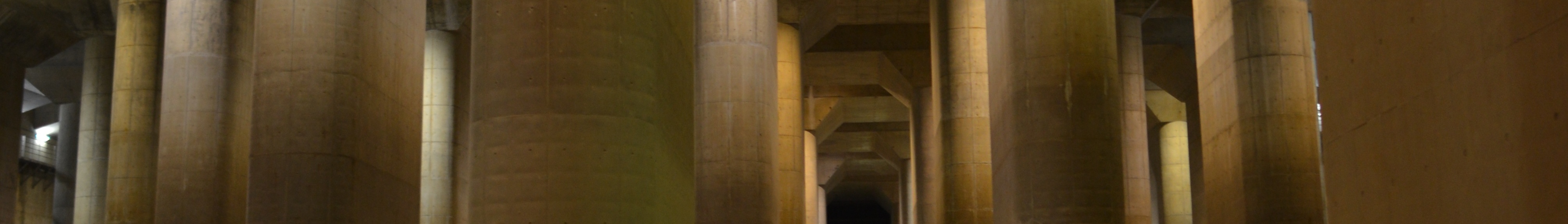
A Cathedral Built for Water
The numbers defy easy comprehension. Five concrete containment silos, each 65 meters tall and 32 meters in diameter, stand buried beneath the suburbs of Kasukabe in Saitama Prefecture, connected by 6.4 kilometers of tunnels bored 50 meters below the surface. But the true spectacle is the pressure-adjusting water tank at the system's heart: 177 meters long, 78 meters wide, and 25.4 meters high, its fifty-nine pillars marching into the distance like the columns of some subterranean basilica. Each pillar weighs approximately 500 tons. Seventy-eight pumps, powered by turbines equivalent to those in a Boeing 737 jet engine, can move 200 tons of water per second from the collection silos into the Edo River. The scale of this engineering is deliberately excessive -- it was built to handle the kind of storm that strikes once in decades.
Taming the Floodplain
The Greater Tokyo Area sprawls across a low-lying alluvial plain where rivers have always been both lifeline and threat. The Nakagawa, Ayase, and other waterways that thread through Saitama's northern suburbs are prone to rapid, dangerous flooding during the June-to-October typhoon season. Before G-Cans, the area around Kasukabe experienced chronic inundation -- homes flooded, roads submerged, lives disrupted year after year. Construction began in 1992, and the system became partially operational in 2002 even before its full completion in 2006. The concept is elegant in its directness: when river levels spike, water pours into the five vertical shafts, rushes through the connecting tunnels, collects in the massive tank, and is pumped out to the broader, deeper Edo River, which can handle the volume without flooding downstream communities.
The Underground Temple
Photographs of the pressure-adjusting tank went viral long before the term existed. The soaring pillars and dramatic lighting earned the facility the nickname 'Underground Temple,' and the images have appeared in science fiction films, video games, and architectural journals worldwide. The resemblance to a flooded cathedral is uncanny and deliberate in how lighting tours are staged. Visitors can book guided tours of the facility, descending 116 steps into the tank itself when it is not in active flood-control mode. Walking between those towering pillars, with footsteps echoing off the concrete walls, the sheer ambition of the project becomes visceral rather than abstract. The central control room, bristling with monitors tracking river levels across the region, underscores that this is no museum -- it is a living system, activated roughly seven times per year.
Engineering as Philosophy
Japan sits at the intersection of tectonic plates, typhoon corridors, and monsoon belts. The country has turned disaster preparedness into something approaching an art form, and G-Cans is perhaps its most dramatic expression. The civic group that lent the facility its popular name -- the 'G-CANS PROJECT' -- envisions the surrounding area as a cultural hub, proof that infrastructure can inspire as well as protect. The facility has become a symbol of a broader national philosophy: that catastrophic natural events are not problems to endure but engineering challenges to solve. Compared to flood barriers in other megacities, G-Cans stands apart in its ambition and its success, having significantly reduced flood damage in the surrounding communities since becoming operational.
From the Air
Located at 36.00N, 139.81E in Kasukabe, Saitama Prefecture. The facility is entirely underground and not visible from the air, but the Kasukabe area sits in the flat Kanto Plain north of central Tokyo, identifiable by the dense suburban grid and the winding Nakagawa River. The Edo River runs to the east. Nearest major airports: Tokyo Haneda (RJTT, ~55 km south), Narita International (RJAA, ~50 km east). Recommended altitude 3,000-5,000 ft to observe the flat floodplain geography that made this project necessary.