Mgahinga Gorilla National Park
Stand on the jagged summit of Mount Sabyinyo and you are in three countries at once. The tooth-like ridges -- Sabyinyo means "old man's teeth" in Kinyarwanda -- mark the precise point where Uganda, Rwanda, and the Democratic Republic of Congo converge, 3,669 meters above sea level. Below, the bamboo forests of Mgahinga Gorilla National Park descend through mist into terraced farmland. Uganda's smallest national park, at just 33.7 square kilometers, guards a fragment of the Virunga volcanic chain that is wildly disproportionate to its size: mountain gorillas, golden monkeys, three climbable volcanoes, and the displaced homeland of one of Africa's oldest peoples.
The Batwa's Lost Forest
For thousands of years before Mgahinga had a name on any map, the Batwa people lived in these forests. They were hunter-gatherers who knew every trail, every cave, every medicinal plant beneath the canopy. The Garama Cave, deep within the park, was a shelter, a meeting place, and a site of spiritual significance. When the Ugandan government gazetted the area as a national park in 1991 to protect the mountain gorillas, the Batwa were forced out of the forest without compensation. Their displacement remains one of the most painful legacies of conservation in East Africa. Today, Batwa guides lead visitors along the Cultural Trail, sharing knowledge of the forest their community can no longer inhabit -- demonstrating fire-making, plant identification, and traditional hunting techniques. Revenue-sharing programs and community craft stalls near the Ntebeko Gate offer some economic return, but the Batwa's relationship to this landscape is one of profound loss as much as cultural pride.
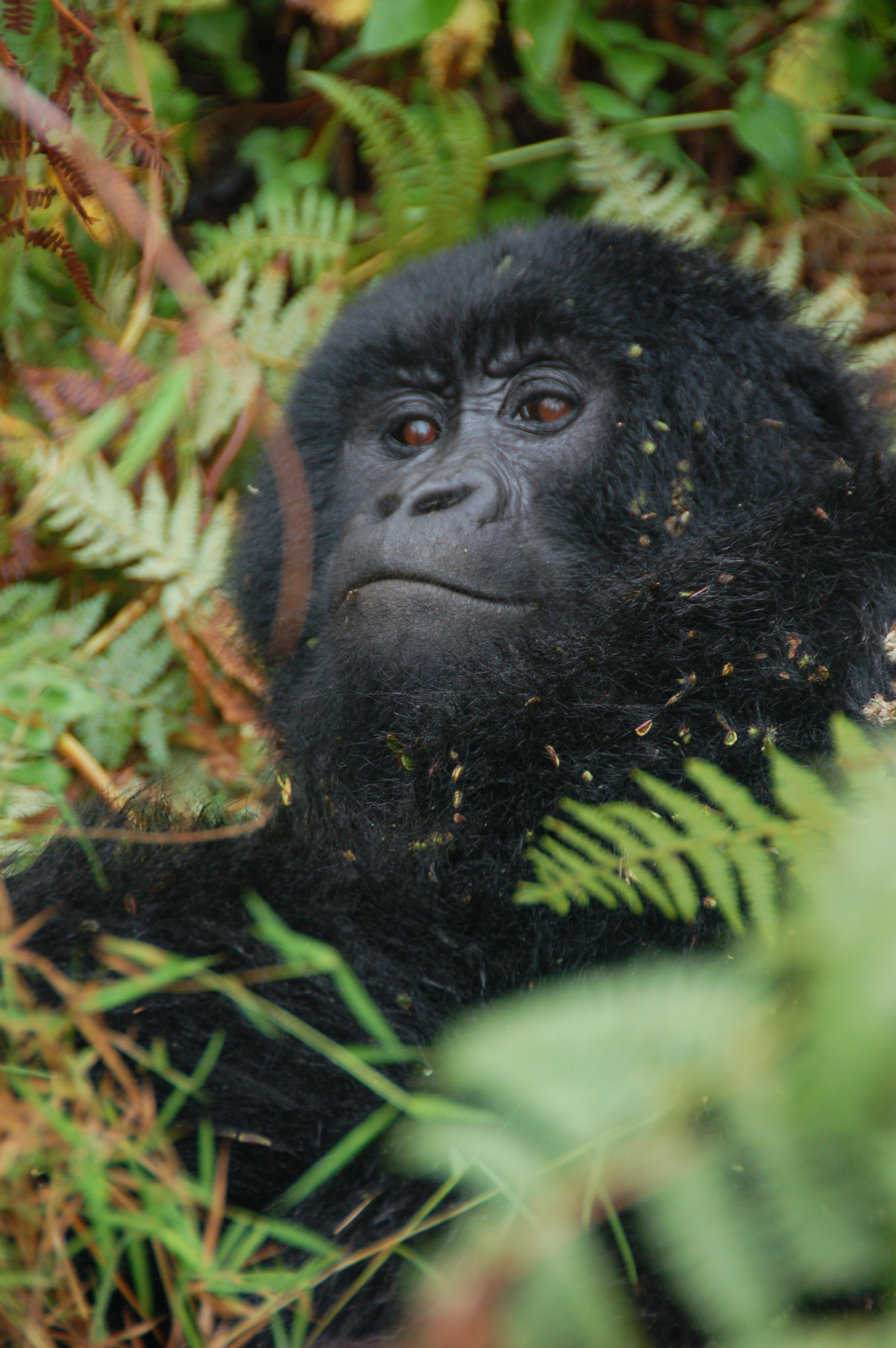
One Family of Gorillas
Mgahinga's gorilla trekking is intimate by design. The park is home to the Nyakagezi family, a single habituated group whose movements sometimes carry them across the border into Rwanda or Congo and back. When they are in Uganda, a small number of trekking permits are issued daily. The experience is quieter and less crowded than at Bwindi Impenetrable Forest, Uganda's other gorilla park -- fewer tourists on the trails, a more solitary feeling in the bamboo. Silverbacks in the Nyakagezi group are known for their relatively calm demeanor around humans, and encounters tend to be close and unhurried. The gorilla permit is significantly less expensive than in neighboring Rwanda, though still substantial. For visitors who value solitude over certainty -- the gorillas do occasionally wander across the border -- Mgahinga offers something the larger parks cannot.
Golden Flashes in the Bamboo
Below the gorilla habitat, in the dense bamboo zone between 2,300 and 2,800 meters, a different primate steals the show. Golden monkeys exist only in the Virunga Mountains, and Mgahinga is one of the best places on Earth to see them. Their orange-gold fur stands out against green bamboo like a signal fire. They move in groups that can exceed a hundred individuals, leaping between stalks, foraging, playing -- kinetic and photogenic in a way that gorillas, with their deliberate stillness, are not. Golden monkey tracking permits cost a fraction of a gorilla permit, and the treks are shorter, making them accessible to visitors with limited time or mobility. Beyond the primates, the park's forests shelter over 180 bird species, including several Albertine Rift endemics -- the Rwenzori turaco, Kivu ground thrush, and handsome francolin among them.
Three Volcanoes, Three Climbs
Each of Mgahinga's three volcanoes offers a different day on the mountain. Gahinga, the gentlest at 3,474 meters, leads through bamboo to a swampy crater at the summit -- not dramatic, but atmospheric, with cloud forest pressing in on all sides. Sabyinyo is the most technical: a scramble up muddy ridges and wooden ladders to a narrow summit where the three-country border converges at a simple concrete marker. Muhabura, the tallest at 4,127 meters, is a long, steep grind rewarded by panoramic views stretching across Rwanda, the Congo, and on clear days, the distant shimmer of Lake Edward. All three climbs take six to eight hours and require a guide and armed ranger. Conditions change rapidly: a sunny departure can turn to freezing rain within an hour. The volcanic soil, already steep, becomes treacherous when wet. Porters are available and recommended -- both for the practical help and because their employment supports anti-poaching efforts in surrounding communities.
Small Park, Big Borders
Mgahinga does not exist in isolation. It is Uganda's piece of the Great Virunga Conservation Area, a transboundary protected zone shared with Volcanoes National Park in Rwanda and Virunga National Park in the DR Congo. The gorillas do not recognize borders. Neither do the golden monkeys, the forest elephants, or the buffaloes that occasionally cross between countries. This cross-border reality shapes everything about the park: its wildlife populations fluctuate depending on which side of the mountains the animals are ranging, and conservation efforts require coordination among three governments with very different security situations. The nearest town, Kisoro, is reachable by a bone-rattling dirt road or daily flights from Entebbe. The park feels remote because it is remote -- perched on the volcanic edge of three nations, wrapped in cloud, guarded by bamboo.
From the Air
Located at 1.37S, 29.63E in the extreme southwest corner of Uganda, where the borders of Uganda, Rwanda, and the DRC converge. The three Virunga volcanoes -- Muhabura (4,127 m), Sabyinyo (3,669 m), and Gahinga (3,474 m) -- are clearly visible from altitude as conical peaks rising above surrounding farmland. The park is immediately south of the town of Kisoro, accessible via Kisoro Airstrip. Nearest international airport: Entebbe International Airport (HUEN), approximately 480 km northeast. Kigali International Airport (HRYR) in Rwanda is closer overland. The Virunga volcanic chain extends northwest into the DRC.