Michigan Territory
The mail from Vincennes to Detroit once had to route through Warren, Ohio -- a detour of hundreds of miles through wilderness and hostile territory. That absurd postal route tells you everything about the Michigan Territory: a vast, contested wilderness that four nations claimed, none fully controlled, and the young United States could barely govern. From 1805 to 1837, the Territory of Michigan was one of America's most improbable political experiments -- a jurisdiction that at its greatest extent stretched from the Great Lakes to the Dakotas, encompassing lands that would become six future states. Its capital, Detroit, had already been French, British, and briefly Canadian before the American flag ever flew above it.
The Fur Trade Frontier
European interest in Michigan was never about the land itself -- it was about the beaver. The first Jesuit mission arrived at Sault Sainte Marie in 1668, and by 1671 another had been established at St. Ignace. Detroit followed in 1701, founded by Antoine de La Mothe Cadillac with the garrison from Fort de Buade. These were not settlements in any conventional sense. They were outposts of a continental fur trade, governed by military commanders who reported to Quebec and existed to supply trappers and discourage anything that might distract from the business of pelts. The Ottawa, Potawatomi, Ojibwa, and Wyandot peoples who actually inhabited these lands had ceded nothing. The French simply established a military presence and began trading.
A Territory Nobody Could Hold
Michigan changed hands with dizzying frequency. France surrendered Montreal in 1760, and British troops under Robert Rogers occupied Detroit. Three years later, Pontiac's Rebellion saw Fort Michilimackinac fall to northern tribes and Fort Detroit endure a lengthy siege. The 1783 Treaty of Paris gave America a paper claim to Michigan, but Britain refused to leave. When Baron von Steuben was sent to negotiate, the Governor of Quebec would not even issue him a passport. The British administered Michigan as part of Upper Canada until Jay's Treaty and the Battle of Fallen Timbers in 1794 finally loosened their grip. On July 11, 1796, Britain evacuated Detroit, and the United States at last had a foothold in its own territory.
The Impossible Geography of Governance
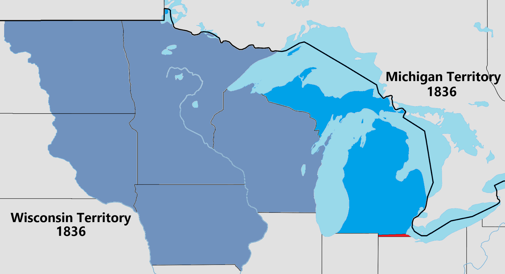
Once established as a territory in 1805, Michigan proved nearly ungovernable. Its first governor, William Hull, abolished the existing county structure and created new districts that proved unworkable. Lewis Cass replaced him in 1813 and reversed everything. During the War of 1812, General Isaac Brock captured Detroit on August 16, 1812, and Michigan became nominally part of Upper Canada again -- Colonel Henry Proctor proclaimed himself governor, then suspended civil government entirely and imposed martial law. When peace returned, the territory kept growing. As Indiana and Illinois achieved statehood in 1816 and 1818, their leftover lands were attached to Michigan. By 1834, the territory had absorbed everything east of the Missouri River that nobody else wanted, including the future states of Wisconsin, Iowa, Minnesota, and much of the Dakotas.
The Toledo War and Statehood
Michigan's path to statehood was blocked by a boundary dispute with Ohio over a narrow strip of land around Toledo. The Toledo War of 1835 produced no casualties but plenty of political drama. Congress ultimately sided with Ohio, giving it the Toledo Strip. Michigan received the western Upper Peninsula as compensation -- a deal that seemed lopsided at the time but delivered vast copper and iron deposits that would fuel Michigan's industrial future. On January 26, 1837, Michigan entered the Union as the 26th state with a population of roughly 200,000, well above the 60,000 minimum required by the Northwest Ordinance. Slavery had been forbidden in the territory since its creation. Detroit served as capital until 1847, when Lansing replaced it.
Shadows on the Land
The Michigan Territory's expansion came at the direct expense of its original inhabitants. The Ottawa, Potawatomi, Ojibwa, and Wyandot peoples signed treaties between 1795 and 1842 -- from the Treaty of Greenville to the Treaty of La Pointe -- ceding lands they had occupied for centuries. Governor Hull's treaty of 1808, the Treaty of Saginaw in 1819, and the Treaties of Chicago in 1821 and 1833 steadily stripped away Native territory. These treaties were often coerced, and the census that counted Michigan's growing population explicitly excluded "Indians not taxed." The territory that became a great American state was built on lands taken from the peoples who gave it its name -- Michigan, from the Ojibwe word mishigamaa, meaning "large water" or "large lake."
From the Air
The Michigan Territory's geographic marker sits at 46.10N, 85.40W, near the northernmost point of Lake Michigan in the Upper Peninsula. From altitude, the Straits of Mackinac are clearly visible, connecting Lake Michigan and Lake Huron -- the strategic chokepoint that made this territory worth fighting over. The Mackinac Bridge spans the straits below. Pellston Regional Airport (PLN) lies 15 miles south. Chippewa County International Airport (CIU) at Sault Ste. Marie serves the eastern UP. Detroit Metropolitan Wayne County Airport (DTW) anchors the territory's old capital region to the south.