Mile End, Montreal
In 1815, an American-born tavern keeper named Stanley Bagg placed a classified ad in the Montreal Gazette. Someone had stolen a bay horse from his pasture at the Mile End Tavern, about two miles from town. He offered ten dollars for its return. Two centuries later, the crossroads where Bagg poured drinks has become one of the most celebrated creative neighborhoods on the continent -- a place where wood-fired bagel ovens burn through the night, post-rock orchestras rehearse in converted garment factories, and the local brewpub offers a beer called "Mild End" in knowing tribute. Mile End's story is a Montreal story in miniature: successive waves of immigrants, each one layering new culture atop the last, until the accumulated weight of all that creativity turned a few blocks of the Plateau-Mont-Royal borough into an international byword for cool.
A Crossroads Becomes a Village
The name Mile End marks a distance that is both literal and approximate. The crossroads at Saint-Laurent Road and what is now Mont-Royal Avenue sits about a mile north of Sherbrooke Street, which in the early 19th century defined the boundary between urban Montreal and open countryside. The name likely borrowed from the East London neighborhood of the same name. By the 1840s, a tollgate at the old city limits funneled traffic past Mile End on its way to the tanneries and limestone quarries that supplied much of Montreal's building stone. The village of Cote Saint-Louis sprang up near those quarries in 1846, and a chapel of the Infant Jesus followed in 1848. When the Quebec, Montreal, Ottawa and Occidental Railway cut through in 1876, Mile End got its first station, its first growth spurt, and a distinct identity apart from the surrounding countryside. The village of Saint-Louis-du-Mile-End was incorporated in 1878 with a population of 1,319.
Rails, Trams, and Explosive Growth
The railway transformed Mile End from a rural crossroads into a proper town. The Canadian Pacific bought the line in 1882, and by 1886, transcontinental trains to Port Moody and Vancouver were departing from the Mile End station on Saint-Laurent Road near Bernard Street. A second boom arrived with electric tramway service in 1893, making Mile End a textbook streetcar suburb. The village became a town in 1895, renamed itself simply Saint-Louis, and built a magnificent town hall in 1905 on the corner of Saint-Laurent and Laurier Avenue -- a building that still serves as a fire hall and firefighters' museum. Population growth was explosive: from 3,537 residents in 1891 to roughly 37,000 by 1911, the year after Montreal annexed the town. The garment industry moved in, drawn by rail access, and for decades Mile End served as the heart of Montreal's clothing manufacturing district.
Immigrant Tapestry
Mile End's ethnic character shifted with every generation. The neighborhood was Montreal's principal Jewish area until the 1950s, a world later made famous by Mordecai Richler, who grew up on Saint Urbain Street in the 1930s and 40s and wrote about it in novels including The Apprenticeship of Duddy Kravitz. Wilensky's Light Lunch, still operating on Fairmount at Clark, features memorably in both the book and the film. Greek and Portuguese communities followed the Jewish migration outward, and the Hassidic community maintained a visible presence in Mile End and neighboring Outremont. William Shatner grew up in the neighborhood before moving to Notre-Dame-de-Grace for high school. North of the railway, early 20th-century Italian immigrants created Montreal's Little Italy, anchored by Jean Talon Market, which opened in 1933 and remains the city's largest public market.
Sound, Ink, and Dough
The creative explosion began in the 1980s and accelerated through the 1990s. Drawn and Quarterly, the independent comics publisher, was founded here in 1989 and opened a flagship bookstore on Bernard in 2007. Discreet Logic renovated a former clothing factory in 1993, and by 1997 the space had become Ubisoft's Montreal studios. Then came the music. Arcade Fire, Godspeed You! Black Emperor, Wolf Parade, Grimes, and Mac DeMarco all called Mile End home. Spin and Pitchfork declared it the heart of Montreal's indie scene in 2005. Venues like Casa del Popolo and La Sala Rossa, along with recording studios like hotel2tango and labels like Constellation Records and Arbutus Records, made the neighborhood a self-sustaining musical ecosystem. Through it all, two rival bagel bakeries -- Fairmount Bagel and St. Viateur Bagel -- kept their wood-fired ovens burning around the clock, fueling a debate that Montrealers treat with the gravity of theology.
The Price of Cool
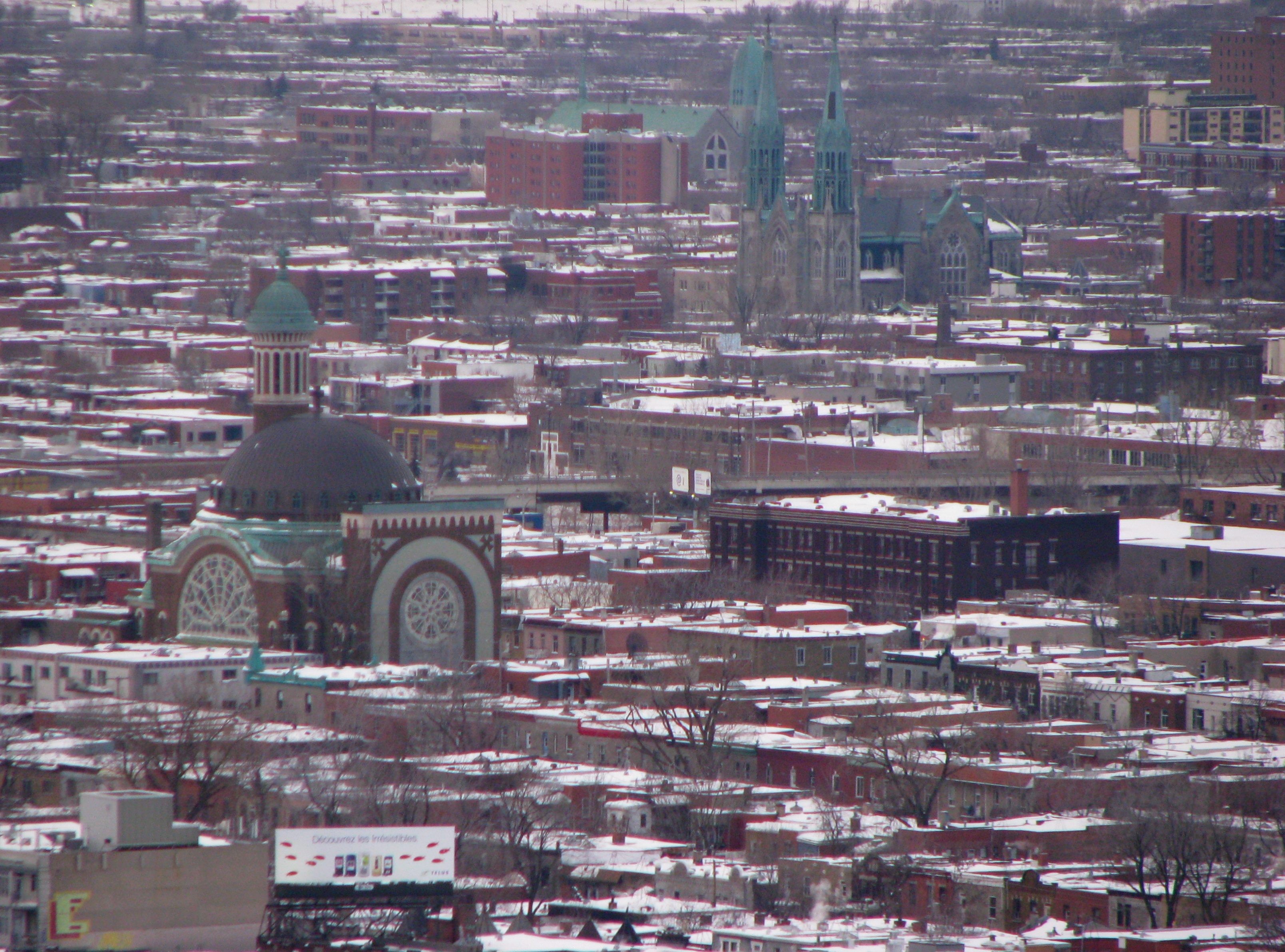
Mile End's reputation became its burden. Gentrification accelerated through the 1990s and 2000s, pushing rents upward and small businesses out. The beloved S.W. Welch bookstore on Saint Viateur Avenue drew hundreds of supporters to a protest read-in in March 2021 but closed its doors in July 2023 anyway. Artists and lower-income residents migrated to Park Extension and other adjacent neighborhoods. The district became so convincingly urban that American film crews used it as a stand-in for New York City on productions including Quantico and Brooklyn, prompting the borough to impose restrictions on new shoots in 2016. Perhaps the most recognizable architectural symbol of the old Mile End is the Church of St. Michael the Archangel, built in 1914-15 for an Irish Catholic congregation. Designed by Aristide Beaugrand-Champagne in a Byzantine style with shamrock motifs and a tower resembling a minaret, it captures the neighborhood's essential character: layers of identity, stacked and fused into something entirely original.
From the Air
Mile End sits at 45.525N, 73.583W in the Plateau-Mont-Royal borough of Montreal, bounded roughly by Mount Royal Avenue to the south, Van Horne Avenue to the north, Hutchison Street to the west, and Saint Denis Street to the east. From the air, the neighborhood is identifiable by its dense residential grid of two- and three-story walk-ups with distinctive exterior staircases, punctuated by the Byzantine dome of the Church of St. Michael the Archangel. The Canadian Pacific railway corridor cuts an east-west line through the northern portion. Best viewed from 2,000-4,000 feet AGL. Montreal/Pierre Elliott Trudeau International Airport (CYUL) is 11 nm to the west. Montreal/Saint-Hubert Airport (CYHU) is 10 nm to the southeast. Mount Royal provides the primary visual landmark to the southwest.